Bois-Bernard
Bois-Bernard is a commune in the Pas-de-Calais department in the Hauts-de-France region in northern France.
Bois-Bernard | |
|---|---|
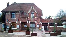 The town hall of Bois Bernard | |
 Coat of arms | |
Location of Bois-Bernard 
| |
 Bois-Bernard  Bois-Bernard | |
| Coordinates: 50°23′39″N 2°54′44″E | |
| Country | France |
| Region | Hauts-de-France |
| Department | Pas-de-Calais |
| Arrondissement | Lens |
| Canton | Harnes |
| Intercommunality | CA Hénin-Carvin |
| Government | |
| • Mayor (2001–2008) | Christine Toutain |
| Area 1 | 3.97 km2 (1.53 sq mi) |
| Population (2017-01-01)[1] | 827 |
| • Density | 210/km2 (540/sq mi) |
| Time zone | UTC+01:00 (CET) |
| • Summer (DST) | UTC+02:00 (CEST) |
| INSEE/Postal code | 62148 /62320 |
| Elevation | 41–70 m (135–230 ft) (avg. 65 m or 213 ft) |
| 1 French Land Register data, which excludes lakes, ponds, glaciers > 1 km2 (0.386 sq mi or 247 acres) and river estuaries. | |
Geography
The village is mainly a farming village located 10 miles (16 km) northeast of Arras on the D919 and D46 roads. It is located on the edge of first world war battlefields and munitions are regularly uncovered by farmers.
History
The village has had various names over the centuries:
- 1162 : Nemus Bernardi,
- 1221 : Boscus Bernardi,
- 1289 : Le Bos Biernart,
- 1362 : Bosbernart,
- 1452 : Boz-Bernard
- 1720 : Le Bois-Bernard.
During World War I, the village was destroyed. It was awarded the Croix de guerre on the 25 September 1920.
Population
| Historical population | ||
|---|---|---|
| Year | Pop. | ±% |
| 1962 | 559 | — |
| 1968 | 609 | +8.9% |
| 1975 | 614 | +0.8% |
| 1982 | 672 | +9.4% |
| 1990 | 816 | +21.4% |
| 1999 | 840 | +2.9% |
| 2009 | 809 | −3.7% |
Sights
- The church of Notre-Dame, rebuilt after the destruction of the village during World War I.
- The ruins of a 13th-century castle.
Twinning
The village is twinned with the village of Grendon in Northamptonshire England.
- "Populations légales 2017". INSEE. Retrieved 6 January 2020.
External links
| Wikimedia Commons has media related to Bois-Bernard. |
- Official website (in French)
| Authority control |
|
|---|
This article is issued from Wikipedia. The text is licensed under Creative Commons - Attribution - Sharealike. Additional terms may apply for the media files.