La Capelle-lès-Boulogne
La Capelle-lès-Boulogne is a commune in the Pas-de-Calais department in the Hauts-de-France region of France.
La Capelle-lès-Boulogne | |
|---|---|
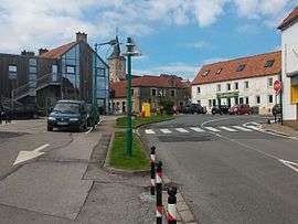 The centre of La Capelle-lès-Boulogne | |
 Coat of arms | |
Location of La Capelle-lès-Boulogne 
| |
 La Capelle-lès-Boulogne  La Capelle-lès-Boulogne | |
| Coordinates: 50°43′55″N 1°42′28″E | |
| Country | France |
| Region | Hauts-de-France |
| Department | Pas-de-Calais |
| Arrondissement | Boulogne-sur-Mer |
| Canton | Boulogne-sur-Mer-1 |
| Intercommunality | Communauté d'agglomération du Boulonnais |
| Government | |
| • Mayor (2008–2014) | Bernard Grare |
| Area 1 | 6.5 km2 (2.5 sq mi) |
| Population (2017-01-01)[1] | 1,629 |
| • Density | 250/km2 (650/sq mi) |
| Time zone | UTC+01:00 (CET) |
| • Summer (DST) | UTC+02:00 (CEST) |
| INSEE/Postal code | 62908 /62360 |
| Elevation | 39–108 m (128–354 ft) (avg. 104 m or 341 ft) |
| 1 French Land Register data, which excludes lakes, ponds, glaciers > 1 km2 (0.386 sq mi or 247 acres) and river estuaries. | |
Geography
A forestry and farming village situated some 4 miles (6.4 km) east of Boulogne, at the junction of the N42 with the D234 and D237.
Main sights
- The church of St.Jean-Baptiste, dating from the 19th century.
- The 18th-century chateau de Conteval.
References
- "Populations légales 2017". INSEE. Retrieved 6 January 2020.
| Wikimedia Commons has media related to La Capelle-lès-Boulogne. |
| Authority control |
|
|---|
This article is issued from Wikipedia. The text is licensed under Creative Commons - Attribution - Sharealike. Additional terms may apply for the media files.