Fontaine-lès-Croisilles
Fontaine-lès-Croisilles is a commune in the Pas-de-Calais department in the Hauts-de-France region of France.
Fontaine-lès-Croisilles | |
|---|---|
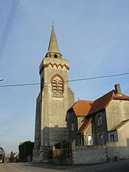 The church of Fontaine-lès-Croisilles | |
 Coat of arms | |
Location of Fontaine-lès-Croisilles 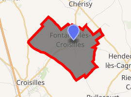
| |
 Fontaine-lès-Croisilles  Fontaine-lès-Croisilles | |
| Coordinates: 50°13′10″N 2°54′34″E | |
| Country | France |
| Region | Hauts-de-France |
| Department | Pas-de-Calais |
| Arrondissement | Arras |
| Canton | Bapaume |
| Intercommunality | CC Sud-Artois |
| Government | |
| • Mayor (2008–2014) | Danièle Tabary |
| Area 1 | 6.26 km2 (2.42 sq mi) |
| Population (2017-01-01)[1] | 278 |
| • Density | 44/km2 (120/sq mi) |
| Time zone | UTC+01:00 (CET) |
| • Summer (DST) | UTC+02:00 (CEST) |
| INSEE/Postal code | 62343 /62128 |
| Elevation | 57–98 m (187–322 ft) (avg. 63 m or 207 ft) |
| 1 French Land Register data, which excludes lakes, ponds, glaciers > 1 km2 (0.386 sq mi or 247 acres) and river estuaries. | |
Geography
A farming village situated 9 miles (14.5 km) southeast of Arras, at the junction of the D9 and the C2 road.
Population
| Year | 1962 | 1968 | 1975 | 1982 | 1990 | 1999 |
|---|---|---|---|---|---|---|
| Population | 215 | 235 | 222 | 228 | 238 | 257 |
| From the year 1962 on: No double counting—residents of multiple communes (e.g. students and military personnel) are counted only once. | ||||||
Places of interest
- The church of St.Maurice, rebuilt, as was all the village, after World War I.
References
- "Populations légales 2017". INSEE. Retrieved 6 January 2020.
| Wikimedia Commons has media related to Fontaine-lès-Croisilles. |
| Authority control |
|
|---|
This article is issued from Wikipedia. The text is licensed under Creative Commons - Attribution - Sharealike. Additional terms may apply for the media files.