Caucourt
Caucourt is a commune in the Pas-de-Calais department in the Hauts-de-France region of France.
Caucourt | |
|---|---|
 The church of Caucourt | |
 Coat of arms | |
Location of Caucourt 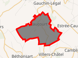
| |
 Caucourt  Caucourt | |
| Coordinates: 50°23′58″N 2°34′20″E | |
| Country | France |
| Region | Hauts-de-France |
| Department | Pas-de-Calais |
| Arrondissement | Béthune |
| Canton | Bruay-la-Buissière |
| Intercommunality | CA Béthune-Bruay, Artois-Lys Romane |
| Government | |
| • Mayor (2008–2014) | Alfred Reschke |
| Area 1 | 5.51 km2 (2.13 sq mi) |
| Population (2017-01-01)[1] | 346 |
| • Density | 63/km2 (160/sq mi) |
| Time zone | UTC+01:00 (CET) |
| • Summer (DST) | UTC+02:00 (CEST) |
| INSEE/Postal code | 62218 /62150 |
| Elevation | 94–157 m (308–515 ft) (avg. 112 m or 367 ft) |
| 1 French Land Register data, which excludes lakes, ponds, glaciers > 1 km2 (0.386 sq mi or 247 acres) and river estuaries. | |
Geography
Caucourt is a farming village some 10 miles (16.1 km) northwest of Arras, at the junction of the D73 and the D73E roads. The "Blanche" stream rises here, forming the source of the Lawe river.
Population
| Year | 1962 | 1968 | 1975 | 1982 | 1990 | 1999 |
|---|---|---|---|---|---|---|
| Population | 282 | 283 | 268 | 275 | 270 | 277 |
| From the year 1962 on: No double counting—residents of multiple communes (e.g. students and military personnel) are counted only once. | ||||||
Places of interest
- The church of St.Pierre, dating from the sixteenth century.
- The war memorial.
- An old watermill.
External links
| Wikimedia Commons has media related to Caucourt. |
- Official municipality website (in French)
- A website about the Commune (in French)
| Authority control |
|
|---|
This article is issued from Wikipedia. The text is licensed under Creative Commons - Attribution - Sharealike. Additional terms may apply for the media files.