Aix-en-Issart
Aix-en-Issart (French pronunciation: [ɛks ɑ̃n‿isaʁ]) is a commune in the Pas-de-Calais department in northern France. A place named in Ascio is mentioned as early as 800 AD while during the Middle Ages the place used to be called Rodenaken by Flemish speaking people.[2]
Aix-en-Issart | |
|---|---|
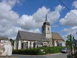 The church of Aix-en-Issart | |
 Coat of arms | |
Location of Aix-en-Issart 
| |
 Aix-en-Issart  Aix-en-Issart | |
| Coordinates: 50°28′39″N 1°51′34″E | |
| Country | France |
| Region | Hauts-de-France |
| Department | Pas-de-Calais |
| Arrondissement | Montreuil |
| Canton | Auxi-le-Château |
| Intercommunality | Sept Vallées |
| Government | |
| • Mayor (2014-2020) | Pierre Lafonte |
| Area 1 | 10.1 km2 (3.9 sq mi) |
| Population (2017-01-01)[1] | 263 |
| • Density | 26/km2 (67/sq mi) |
| Time zone | UTC+01:00 (CET) |
| • Summer (DST) | UTC+02:00 (CEST) |
| INSEE/Postal code | 62018 /62170 |
| Elevation | 15–125 m (49–410 ft) (avg. 22 m or 72 ft) |
| 1 French Land Register data, which excludes lakes, ponds, glaciers > 1 km2 (0.386 sq mi or 247 acres) and river estuaries. | |
Geography
A small village situated some 5 miles(7 km) east of Montreuil-sur-Mer, at the D149 and D129 crossroads, by the banks of the small river Bras de Brosne, a tributary of the Canche.

Map of the commune and adjacent places

Chateau
Population
| Historical population | ||
|---|---|---|
| Year | Pop. | ±% |
| 2006 | 259 | — |
| 2007 | 266 | +2.7% |
| 2008 | 273 | +2.6% |
| 2009 | 281 | +2.9% |
| 2010 | 274 | −2.5% |
| 2011 | 267 | −2.6% |
| 2012 | 260 | −2.6% |
| 2013 | 268 | +3.1% |
| 2014 | 267 | −0.4% |
| 2015 | 266 | −0.4% |
| 2016 | 264 | −0.8% |
References
- "Populations légales 2017". INSEE. Retrieved 6 January 2020.
- Aix-en-Issart/Rodenaken: proussel.voila.net Archived 2015-07-05 at the Wayback Machine
| Wikimedia Commons has media related to Aix-en-Issart. |
| Authority control |
|
|---|
This article is issued from Wikipedia. The text is licensed under Creative Commons - Attribution - Sharealike. Additional terms may apply for the media files.