Saint-Venant
Saint-Venant is a commune in the Pas-de-Calais department (administrative division) in the Hauts-de-France region of France.
Saint-Venant | |
|---|---|
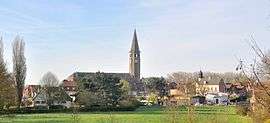 A general view of Saint-Venant | |
 Coat of arms | |
Location of Saint-Venant 
| |
 Saint-Venant  Saint-Venant | |
| Coordinates: 50°37′24″N 2°32′43″E | |
| Country | France |
| Region | Hauts-de-France |
| Department | Pas-de-Calais |
| Arrondissement | Béthune |
| Canton | Lillers |
| Intercommunality | CA Béthune-Bruay, Artois-Lys Romane |
| Government | |
| • Mayor (2008–2014) | André Flajolet |
| Area 1 | 14.24 km2 (5.50 sq mi) |
| Population (2017-01-01)[1] | 3,027 |
| • Density | 210/km2 (550/sq mi) |
| Time zone | UTC+01:00 (CET) |
| • Summer (DST) | UTC+02:00 (CEST) |
| INSEE/Postal code | 62770 /62350 |
| 1 French Land Register data, which excludes lakes, ponds, glaciers > 1 km2 (0.386 sq mi or 247 acres) and river estuaries. | |
Geography
Saint-Venant is situated some 9 miles (14.5 km) northwest of Béthune and 26 miles (41.8 km) west of Lille, at the junction of the D186 and D916 roads and by the banks of the Lys River.
Population
| 1962 | 1968 | 1975 | 1982 | 1990 | 1999 | 2006 |
|---|---|---|---|---|---|---|
| 4029 | 4328 | 3988 | 4127 | 3887 | 3208 | 3367 |
| Census count starting from 1962: Population without duplicates | ||||||
Places of interest
- The church of St. Venant, rebuilt along with much of the village after the First World War.
- The Hotel de Ville (Town Hall), dating from the eighteenth century.
- The civilian cemetery, incorporating a Commonwealth War Graves Commission cemetery and the grave of Edward Gordon Williams.
- The town's war memorial.
- A memorial to the Royal Welch Fusiliers.[2]
- Gardens of the Manoir de La Peylouse, incorporating an exhibition on First World War poetry.[3]
References
- "Populations légales 2017". INSEE. Retrieved 6 January 2020.
- Michael Glover & Jonathan Riley, 'That Astonishing Infantry': The History of The Royal Welch Fusiliers 1689-2006, p299
- Comite des Parcs et Jardins de France website/ Accessed 15 September 2014
External links
| Wikimedia Commons has media related to Saint-Venant. |
| Authority control |
|
|---|
This article is issued from Wikipedia. The text is licensed under Creative Commons - Attribution - Sharealike. Additional terms may apply for the media files.