Les Attaques
Les Attaques is a commune in the Pas-de-Calais department in the Hauts-de-France region of France.
Les Attaques | |
|---|---|
 The church of Les Attaques | |
 Coat of arms | |
Location of Les Attaques 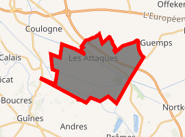
| |
 Les Attaques  Les Attaques | |
| Coordinates: 50°54′28″N 1°56′05″E | |
| Country | France |
| Region | Hauts-de-France |
| Department | Pas-de-Calais |
| Arrondissement | Calais |
| Canton | Calais-2 |
| Intercommunality | CA Grand Calais Terres et Mers |
| Government | |
| • Mayor (2014-2020) | Jacques Rivenet |
| Area 1 | 20.81 km2 (8.03 sq mi) |
| Population (2017-01-01)[1] | 1,978 |
| • Density | 95/km2 (250/sq mi) |
| Time zone | UTC+01:00 (CET) |
| • Summer (DST) | UTC+02:00 (CEST) |
| INSEE/Postal code | 62043 /62730 |
| Elevation | 0–6 m (0–20 ft) (avg. 3 m or 9.8 ft) |
| 1 French Land Register data, which excludes lakes, ponds, glaciers > 1 km2 (0.386 sq mi or 247 acres) and river estuaries. | |
Geography
A large farming and light industrial village located 4 miles (6 km) southeast of Calais, at the junction of the N43 and D248 roads. Both the A26 ‘autoroute des Anglaises’ and the Calais-St. Omer canal pass through the commune.
Population
| Historical population | ||
|---|---|---|
| Year | Pop. | ±% |
| 1962 | 1,773 | — |
| 1968 | 1,790 | +1.0% |
| 1975 | 1,775 | −0.8% |
| 1982 | 1,878 | +5.8% |
| 1990 | 1,887 | +0.5% |
| 1999 | 1,821 | −3.5% |
| 2006 | 1,961 | +7.7% |
| 2009 | 2,000 | +2.0% |
| 2011 | 1,958 | −2.1% |
| 2015 | 1,945 | −0.7% |
Sights
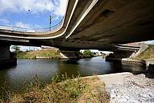
Underside of Les Attaques' four-way bridge
- The church of St. Pierre, dating from the nineteenth century.
- The nineteenth-century chateau Brûlé.
- Vestiges of a Capuchin abbey.
- A rare four-branch bridge
External links
| Wikimedia Commons has media related to Les Attaques. |
- Les Attaques official website (in French)
- Website of the football club of Les Attaques (in French)
| Authority control |
|
|---|
This article is issued from Wikipedia. The text is licensed under Creative Commons - Attribution - Sharealike. Additional terms may apply for the media files.