Hautecloque, Pas-de-Calais
Hautecloque (French pronunciation: [otklɔk]) is a commune in the Pas-de-Calais department in the Hauts-de-France region of France.
Hautecloque | |
|---|---|
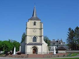 The church of Hautecloque | |
 Coat of arms | |
Location of Hautecloque 
| |
 Hautecloque  Hautecloque | |
| Coordinates: 50°20′22″N 2°18′24″E | |
| Country | France |
| Region | Hauts-de-France |
| Department | Pas-de-Calais |
| Arrondissement | Arras |
| Canton | Saint-Pol-sur-Ternoise |
| Intercommunality | CC Ternois |
| Government | |
| • Mayor (2008–2014) | Marc Bridoux |
| Area 1 | 6.84 km2 (2.64 sq mi) |
| Population (2017-01-01)[1] | 218 |
| • Density | 32/km2 (83/sq mi) |
| Time zone | UTC+01:00 (CET) |
| • Summer (DST) | UTC+02:00 (CEST) |
| INSEE/Postal code | 62416 /62130 |
| Elevation | 108–152 m (354–499 ft) (avg. 150 m or 490 ft) |
| 1 French Land Register data, which excludes lakes, ponds, glaciers > 1 km2 (0.386 sq mi or 247 acres) and river estuaries. | |
Geography
A farming village situated 23 miles (37 km) west of Arras, at the junction of the D102 and the D102E roads.
Population
| Year | 1962 | 1968 | 1975 | 1982 | 1990 | 1999 |
|---|---|---|---|---|---|---|
| Population | 165 | 198 | 194 | 202 | 179 | 186 |
| From the year 1962 on: No double counting—residents of multiple communes (e.g. students and military personnel) are counted only once. | ||||||
Places of interest
- The nineteenth-century chateau of Hautecloque.
- The eighteenth-century chateau of Sains.
- The church of St. Leger, dating from the sixteenth century.
- Traces of an old castle.
References
- "Populations légales 2017". INSEE. Retrieved 6 January 2020.
| Wikimedia Commons has media related to Hautecloque. |
| Authority control |
|
|---|
This article is issued from Wikipedia. The text is licensed under Creative Commons - Attribution - Sharealike. Additional terms may apply for the media files.