Roëllecourt
Roëllecourt is a commune in the Pas-de-Calais department in the Hauts-de-France region of France.
Roëllecourt | |
|---|---|
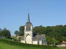 The church of Roëllecourt | |
 Coat of arms | |
Location of Roëllecourt 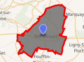
| |
 Roëllecourt  Roëllecourt | |
| Coordinates: 50°22′06″N 2°23′13″E | |
| Country | France |
| Region | Hauts-de-France |
| Department | Pas-de-Calais |
| Arrondissement | Arras |
| Canton | Saint-Pol-sur-Ternoise |
| Intercommunality | CC Ternois |
| Government | |
| • Mayor (2008–2014) | Jean-Michel Lefebvre |
| Area 1 | 9.42 km2 (3.64 sq mi) |
| Population (2017-01-01)[1] | 538 |
| • Density | 57/km2 (150/sq mi) |
| Time zone | UTC+01:00 (CET) |
| • Summer (DST) | UTC+02:00 (CEST) |
| INSEE/Postal code | 62717 /62130 |
| Elevation | 95–150 m (312–492 ft) (avg. 115 m or 377 ft) |
| 1 French Land Register data, which excludes lakes, ponds, glaciers > 1 km2 (0.386 sq mi or 247 acres) and river estuaries. | |
Geography
Roëllecourt lies just outside Saint-Pol, some 19 miles (31 km) west of Arras, at the junction of the D8 and N39 roads.
Population
| 1962 | 1968 | 1975 | 1982 | 1990 | 1999 | 2006 |
|---|---|---|---|---|---|---|
| 323 | 354 | 366 | 462 | 541 | 595 | 512 |
| Census count starting from 1962: Population without duplicates | ||||||
Places of interest
- The sixteenth-century church of St.Omer.
- An eighteenth-century manor house
- A chapel.
- Traces of an old castle.
External links
| Wikimedia Commons has media related to Roëllecourt. |
- Roëllecourt on the Quid website (in French)
| Authority control |
|
|---|
This article is issued from Wikipedia. The text is licensed under Creative Commons - Attribution - Sharealike. Additional terms may apply for the media files.