Mencas
Mencas is a commune in the Pas-de-Calais department in the Hauts-de-France region of France.
Mencas | |
|---|---|
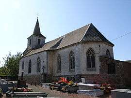 The church of Mencas | |
 Coat of arms | |
Location of Mencas 
| |
 Mencas  Mencas | |
| Coordinates: 50°33′37″N 2°08′23″E | |
| Country | France |
| Region | Hauts-de-France |
| Department | Pas-de-Calais |
| Arrondissement | Montreuil |
| Canton | Fruges |
| Intercommunality | CC Haut Pays du Montreuillois |
| Government | |
| • Mayor | Serge Dulot |
| Area 1 | 2.02 km2 (0.78 sq mi) |
| Population (2017-01-01)[1] | 77 |
| • Density | 38/km2 (99/sq mi) |
| Time zone | UTC+01:00 (CET) |
| • Summer (DST) | UTC+02:00 (CEST) |
| INSEE/Postal code | 62565 /62310 |
| Elevation | 62–108 m (203–354 ft) (avg. 73 m or 240 ft) |
| 1 French Land Register data, which excludes lakes, ponds, glaciers > 1 km2 (0.386 sq mi or 247 acres) and river estuaries. | |
Geography
Mencas is situated in the valley of the Lys river, 20 miles (32 km) northeast of Montreuil-sur-Mer, on the D133 road.
Population
| 1962 | 1968 | 1975 | 1982 | 1990 | 1999 | 2006 |
|---|---|---|---|---|---|---|
| 97 | 98 | 90 | 92 | 90 | 81 | 96 |
| Census count starting from 1962: Population without duplicates | ||||||
Places of interest
- The church of the Visitation.
References
- "Populations légales 2017". INSEE. Retrieved 6 January 2020.
| Wikimedia Commons has media related to Mencas. |
| Authority control |
|
|---|
This article is issued from Wikipedia. The text is licensed under Creative Commons - Attribution - Sharealike. Additional terms may apply for the media files.