Fresnicourt-le-Dolmen
Fresnicourt-le-Dolmen is a commune in the Pas-de-Calais department in the Hauts-de-France region of France.
Fresnicourt-le-Dolmen | |
|---|---|
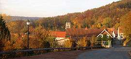 A general view of Fresnicourt-le-Dolmen | |
 Coat of arms | |
Location of Fresnicourt-le-Dolmen 
| |
 Fresnicourt-le-Dolmen  Fresnicourt-le-Dolmen | |
| Coordinates: 50°25′08″N 2°36′02″E | |
| Country | France |
| Region | Hauts-de-France |
| Department | Pas-de-Calais |
| Arrondissement | Béthune |
| Canton | Bruay-la-Buissière |
| Intercommunality | CA Béthune-Bruay, Artois-Lys Romane |
| Government | |
| • Mayor (2008–2014) | Michel Fréville |
| Area 1 | 7.95 km2 (3.07 sq mi) |
| Population (2017-01-01)[1] | 772 |
| • Density | 97/km2 (250/sq mi) |
| Time zone | UTC+01:00 (CET) |
| • Summer (DST) | UTC+02:00 (CEST) |
| INSEE/Postal code | 62356 /62150 |
| Elevation | 77–186 m (253–610 ft) (avg. 188 m or 617 ft) |
| 1 French Land Register data, which excludes lakes, ponds, glaciers > 1 km2 (0.386 sq mi or 247 acres) and river estuaries. | |
Geography
Fresnicourt-le-Dolmen is a farming village situated some 10 miles (16.1 km) south of Béthune and 20 miles (32.2 km) southwest of Lille, on the D57 road.
Population
| Year | 1962 | 1968 | 1975 | 1982 | 1990 | 1999 |
|---|---|---|---|---|---|---|
| Population | 997 | 1078 | 1014 | 974 | 907 | 880 |
| From the year 1962 on: No double counting—residents of multiple communes (e.g. students and military personnel) are counted only once. | ||||||
Places of interest
- The church of Notre-Dame, rebuilt on old foundations during the 19th century.
- A group of dolmen, known as the Table des Fées (The Fairies' Table).
- The fifteenth century Château d'Olhain.
- The Arboretum d'Olhain
 The Table des fées
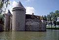 The Château d'Olhain
External links
| Wikimedia Commons has media related to Fresnicourt-le-Dolmen. |
| Authority control |
|
|---|
This article is issued from Wikipedia. The text is licensed under Creative Commons - Attribution - Sharealike. Additional terms may apply for the media files.