Marles-les-Mines
Marles-les-Mines is a commune in the Pas-de-Calais department in the Hauts-de-France region of France.
Marles-les-Mines | |
|---|---|
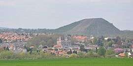 A general view of Marles les Mines | |
 Coat of arms | |
Location of Marles-les-Mines 
| |
 Marles-les-Mines  Marles-les-Mines | |
| Coordinates: 50°30′10″N 2°30′11″E | |
| Country | France |
| Region | Hauts-de-France |
| Department | Pas-de-Calais |
| Arrondissement | Béthune |
| Canton | Auchel |
| Intercommunality | CA Béthune-Bruay, Artois-Lys Romane |
| Government | |
| • Mayor (2008–2014) | Marcel Coffre |
| Area 1 | 4.55 km2 (1.76 sq mi) |
| Population (2017-01-01)[1] | 5,579 |
| • Density | 1,200/km2 (3,200/sq mi) |
| Time zone | UTC+01:00 (CET) |
| • Summer (DST) | UTC+02:00 (CEST) |
| INSEE/Postal code | 62555 /62540 |
| Elevation | 37–99 m (121–325 ft) (avg. 40 m or 130 ft) |
| 1 French Land Register data, which excludes lakes, ponds, glaciers > 1 km2 (0.386 sq mi or 247 acres) and river estuaries. | |
Geography
As the name suggests, an ex-coalmining town, which now relies on light industry and farming. It is situated some 5 miles (8.0 km) southwest of Béthune and 36 miles (57.9 km) southwest of Lille, at the junction of the D70 and D188 roads. The Clarence River flows through the commune.
Population
| 1962 | 1968 | 1975 | 1982 | 1990 | 1999 | 2006 |
|---|---|---|---|---|---|---|
| 8765 | 9942 | 7938 | 7327 | 6790 | 6088 | 5869 |
| Census count starting from 1962: Population without duplicates | ||||||
Places of interest
- The church of St. Vaast, dating from the sixteenth century.
- Some remains of the coal industry – pit head machinery and buildings.
References
- "Populations légales 2017". INSEE. Retrieved 6 January 2020.
| Wikimedia Commons has media related to Marles-les-Mines. |
| Authority control |
|
|---|
This article is issued from Wikipedia. The text is licensed under Creative Commons - Attribution - Sharealike. Additional terms may apply for the media files.