Étaing
Étaing is a commune in the Pas-de-Calais department in the Hauts-de-France region of France.
Étaing | |
|---|---|
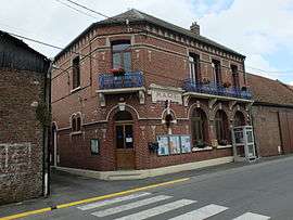 The town hall of Étaing | |
 Coat of arms | |
Location of Étaing 
| |
 Étaing  Étaing | |
| Coordinates: 50°16′28″N 3°00′02″E | |
| Country | France |
| Region | Hauts-de-France |
| Department | Pas-de-Calais |
| Arrondissement | Arras |
| Canton | Brebières |
| Intercommunality | CC Osartis Marquion |
| Government | |
| • Mayor (2008–2014) | Daniel Lepoivre |
| Area 1 | 5.1 km2 (2.0 sq mi) |
| Population (2017-01-01)[1] | 450 |
| • Density | 88/km2 (230/sq mi) |
| Time zone | UTC+01:00 (CET) |
| • Summer (DST) | UTC+02:00 (CEST) |
| INSEE/Postal code | 62317 /62156 |
| Elevation | 37–74 m (121–243 ft) (avg. 43 m or 141 ft) |
| 1 French Land Register data, which excludes lakes, ponds, glaciers > 1 km2 (0.386 sq mi or 247 acres) and river estuaries. | |
Geography
A farming village situated 11 miles (17.7 km) east of Arras, in the valley of the river Sensee, at the junction of the D39 and D9 roads. The A26 autoroute passes by about half a mile from the village.
Population
| Year | 1962 | 1968 | 1975 | 1982 | 1990 | 1999 |
|---|---|---|---|---|---|---|
| Population | 351 | 353 | 383 | 366 | 356 | 367 |
| From the year 1962 on: No double counting—residents of multiple communes (e.g. students and military personnel) are counted only once. | ||||||
Places of interest
- The church of Notre-Dame, rebuilt, as was the rest of the village, after World War I.
External links
| Wikimedia Commons has media related to Étaing. |
- Étaing on the Quid website (in French)
This article is issued from Wikipedia. The text is licensed under Creative Commons - Attribution - Sharealike. Additional terms may apply for the media files.