Moringhem
Moringhem is a commune in the Pas-de-Calais department in the Hauts-de-France region of France.
Moringhem | |
|---|---|
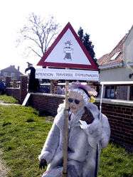 Scarecrow Festival | |
 Coat of arms | |
Location of Moringhem 
| |
 Moringhem  Moringhem | |
| Coordinates: 50°45′50″N 2°07′42″E | |
| Country | France |
| Region | Hauts-de-France |
| Department | Pas-de-Calais |
| Arrondissement | Saint-Omer |
| Canton | Saint-Omer |
| Intercommunality | Pays de Saint-Omer |
| Government | |
| • Mayor | Hugues Persyn |
| Area 1 | 9.98 km2 (3.85 sq mi) |
| Population (2017-01-01)[1] | 558 |
| • Density | 56/km2 (140/sq mi) |
| Time zone | UTC+01:00 (CET) |
| • Summer (DST) | UTC+02:00 (CEST) |
| INSEE/Postal code | 62592 /62910 |
| Elevation | 37–166 m (121–545 ft) (avg. 93 m or 305 ft) |
| 1 French Land Register data, which excludes lakes, ponds, glaciers > 1 km2 (0.386 sq mi or 247 acres) and river estuaries. | |
Geography
Moringhem lies about 5 miles (8 km) west of Saint-Omer, at the D207 and D223 crossroads. The A26 autoroute passes by about a half mile to the west.
Population
| 1962 | 1968 | 1975 | 1982 | 1990 | 1999 | 2006 |
|---|---|---|---|---|---|---|
| 339 | 360 | 368 | 363 | 361 | 383 | 464 |
| Census count starting from 1962: Population without duplicates | ||||||
Places of interest
- The stone tower of an 18th-century windmill.
- The church of St. Andre, dating from the eighteenth century.
- The church of St.Maxime at Difques, dating from the fifteenth century.
- The chapel of Barbinghein, built in 1714.
External links
| Wikimedia Commons has media related to Moringhem. |
- Scarecrow info (in French)
 April scarecrow festival
 The scarecrows of Moringhem
| Authority control |
|
|---|
This article is issued from Wikipedia. The text is licensed under Creative Commons - Attribution - Sharealike. Additional terms may apply for the media files.