Rebreuve-sur-Canche
Rebreuve-sur-Canche is a commune in the Pas-de-Calais department in the Hauts-de-France region of France.
Rebreuve-sur-Canche | |
|---|---|
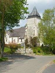 The church of Rebreuve-sur-Canche | |
 Coat of arms | |
Location of Rebreuve-sur-Canche 
| |
 Rebreuve-sur-Canche  Rebreuve-sur-Canche | |
| Coordinates: 50°15′55″N 2°20′30″E | |
| Country | France |
| Region | Hauts-de-France |
| Department | Pas-de-Calais |
| Arrondissement | Arras |
| Canton | Avesnes-le-Comte |
| Intercommunality | CC Campagnes de l'Artois |
| Government | |
| • Mayor (2008–2014) | Daniel Bonnelle |
| Area 1 | 8.28 km2 (3.20 sq mi) |
| Population (2017-01-01)[1] | 194 |
| • Density | 23/km2 (61/sq mi) |
| Time zone | UTC+01:00 (CET) |
| • Summer (DST) | UTC+02:00 (CEST) |
| INSEE/Postal code | 62694 /62270 |
| Elevation | 72–149 m (236–489 ft) (avg. 76 m or 249 ft) |
| 1 French Land Register data, which excludes lakes, ponds, glaciers > 1 km2 (0.386 sq mi or 247 acres) and river estuaries. | |
Geography
Rebreuve-sur-Canche lies on the banks of the river Canche, 19 miles (31 km) west of Arras, at the junction of the D84 and D339 roads.
Population
| 1962 | 1968 | 1975 | 1982 | 1990 | 1999 | 2006 |
|---|---|---|---|---|---|---|
| 220 | 230 | 176 | 183 | 199 | 180 | 218 |
| Census count starting from 1962: Population without duplicates | ||||||
Places of interest
- The church of St.Vaast, dating from the sixteenth century.
- An eighteenth-century manor house.
External links
| Wikimedia Commons has media related to Rebreuve-sur-Canche. |
- Rebreuve-sur-Canche on the Quid website (in French)
| Authority control |
|
|---|
This article is issued from Wikipedia. The text is licensed under Creative Commons - Attribution - Sharealike. Additional terms may apply for the media files.