La Comté
La Comté is a commune in the Pas-de-Calais department in the Hauts-de-France region of France.
La Comté | |
|---|---|
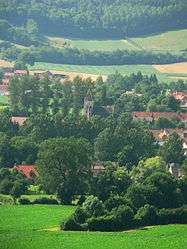 A general view of La Comté | |
 Coat of arms | |
Location of La Comté 
| |
 La Comté  La Comté | |
| Coordinates: 50°25′39″N 2°30′03″E | |
| Country | France |
| Region | Hauts-de-France |
| Department | Pas-de-Calais |
| Arrondissement | Béthune |
| Canton | Bruay-la-Buissière |
| Intercommunality | CA Béthune-Bruay, Artois-Lys Romane |
| Government | |
| • Mayor (2008–2014) | Allemand |
| Area 1 | 6.63 km2 (2.56 sq mi) |
| Population (2017-01-01)[1] | 935 |
| • Density | 140/km2 (370/sq mi) |
| Time zone | UTC+01:00 (CET) |
| • Summer (DST) | UTC+02:00 (CEST) |
| INSEE/Postal code | 62232 /62150 |
| Elevation | 70–193 m (230–633 ft) (avg. 91 m or 299 ft) |
| 1 French Land Register data, which excludes lakes, ponds, glaciers > 1 km2 (0.386 sq mi or 247 acres) and river estuaries. | |
Geography
La Comté is a farming and light industrial village situated 18 miles (29 km) northwest of Arras, at the junction of the D86 and the D86E roads, in the valley of the river Lawe.
Population
| Year | 1962 | 1968 | 1975 | 1982 | 1990 | 1999 |
|---|---|---|---|---|---|---|
| Population | 734 | 735 | 734 | 685 | 755 | 783 |
| From the year 1962 on: No double counting—residents of multiple communes (e.g. students and military personnel) are counted only once. | ||||||
Places of interest
- The church of St.Martin, dating from the sixteenth century.
- An eighteenth-century farmhouse, at a site known as the old castle.
References
- "Populations légales 2017". INSEE. Retrieved 6 January 2020.
| Wikimedia Commons has media related to La Comté. |
This article is issued from Wikipedia. The text is licensed under Creative Commons - Attribution - Sharealike. Additional terms may apply for the media files.