Graincourt-lès-Havrincourt
Graincourt-lès-Havrincourt is a commune in the Pas-de-Calais department in the Hauts-de-France region of France.
Graincourt-lès-Havrincourt | |
|---|---|
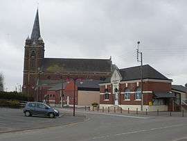 The center of the commune | |
 Coat of arms | |
Location of Graincourt-lès-Havrincourt 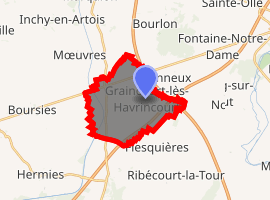
| |
 Graincourt-lès-Havrincourt  Graincourt-lès-Havrincourt | |
| Coordinates: 50°08′43″N 3°06′37″E | |
| Country | France |
| Region | Hauts-de-France |
| Department | Pas-de-Calais |
| Arrondissement | Arras |
| Canton | Bapaume |
| Intercommunality | CC Osartis Marquion |
| Government | |
| • Mayor (2008–2014) | Jean-Marcel Dumont |
| Area 1 | 11.57 km2 (4.47 sq mi) |
| Population (2017-01-01)[1] | 638 |
| • Density | 55/km2 (140/sq mi) |
| Time zone | UTC+01:00 (CET) |
| • Summer (DST) | UTC+02:00 (CEST) |
| INSEE/Postal code | 62384 /62147 |
| Elevation | 61–101 m (200–331 ft) (avg. 79 m or 259 ft) |
| 1 French Land Register data, which excludes lakes, ponds, glaciers > 1 km2 (0.386 sq mi or 247 acres) and river estuaries. | |
Geography
A farming village situated 22 miles (35.4 km) southeast of Arras, at the junction of the D15 and C5 roads. The A26 autoroute junction with the A2 autoroute is only half a mile from the commune.
Population
| Year | 1962 | 1968 | 1975 | 1982 | 1990 | 1999 |
|---|---|---|---|---|---|---|
| Population | 629 | 633 | 605 | 610 | 611 | 617 |
| From the year 1962 on: No double counting—residents of multiple communes (e.g. students and military personnel) are counted only once. | ||||||
Places of interest
- The church of St.Martin, rebuilt along with the rest of the village after World War I.
- The Commonwealth War Graves Commission cemetery.
External links
| Wikimedia Commons has media related to Graincourt-lès-Havrincourt. |
| Authority control |
|
|---|
This article is issued from Wikipedia. The text is licensed under Creative Commons - Attribution - Sharealike. Additional terms may apply for the media files.