Sailly-en-Ostrevent
Sailly-en-Ostrevent is a commune in the Pas-de-Calais department in the Hauts-de-France region of France.
Sailly-en-Ostrevent | |
|---|---|
 Dolmens | |
 Coat of arms | |
Location of Sailly-en-Ostrevent 
| |
 Sailly-en-Ostrevent  Sailly-en-Ostrevent | |
| Coordinates: 50°17′21″N 2°59′41″E | |
| Country | France |
| Region | Hauts-de-France |
| Department | Pas-de-Calais |
| Arrondissement | Arras |
| Canton | Brebières |
| Intercommunality | CC Osartis Marquion |
| Government | |
| • Mayor (2008–2014) | Anne-Sophie Deroubaix |
| Area 1 | 7.43 km2 (2.87 sq mi) |
| Population (2017-01-01)[1] | 722 |
| • Density | 97/km2 (250/sq mi) |
| Time zone | UTC+01:00 (CET) |
| • Summer (DST) | UTC+02:00 (CEST) |
| INSEE/Postal code | 62734 /62490 |
| Elevation | 38–74 m (125–243 ft) (avg. 48 m or 157 ft) |
| 1 French Land Register data, which excludes lakes, ponds, glaciers > 1 km2 (0.386 sq mi or 247 acres) and river estuaries. | |
Geography
Sailly-en-Ostrevent lies about 12 miles (19 km) east of Arras, at the junction of the D39 and D43 roads.
Population
| Year | 1962 | 1968 | 1975 | 1982 | 1990 | 1999 | 2006 |
|---|---|---|---|---|---|---|---|
| Population | 679 | 660 | 640 | 666 | 649 | 647 | 279 |
| From the year 1962 on: No double counting—residents of multiple communes (e.g. students and military personnel) are counted only once. | |||||||
Places of interest
- The church of St. Albin, rebuilt along with much of the village after World War I.
- The stone circle of Bonnettes.
In the fields of the commune stands a mound about five metres high, on which are erected five (there were once seven) large stones (dolmen or menhir). The last excavations took place in 1887 but no clues or evidence was discovered as to the origins of the monument.
References
- "Populations légales 2017". INSEE. Retrieved 6 January 2020.
| Wikimedia Commons has media related to Sailly-en-Ostrevent. |
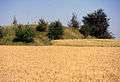 The mound
 Another angle
| Authority control |
|
|---|
This article is issued from Wikipedia. The text is licensed under Creative Commons - Attribution - Sharealike. Additional terms may apply for the media files.