Annequin
Annequin is a commune in the Pas-de-Calais department in the Hauts-de-France region of France.
Annequin | |
|---|---|
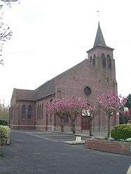 The church of Annequin | |
 Coat of arms | |
Location of Annequin 
| |
 Annequin  Annequin | |
| Coordinates: 50°30′28″N 2°43′33″E | |
| Country | France |
| Region | Hauts-de-France |
| Department | Pas-de-Calais |
| Arrondissement | Béthune |
| Canton | Douvrin |
| Intercommunality | Communauté d'agglomération de Béthune-Bruay, Artois-Lys Romane |
| Government | |
| • Mayor (2014-2020) | Yves Dupont |
| Area 1 | 3.99 km2 (1.54 sq mi) |
| Population (2017-01-01)[1] | 2,201 |
| • Density | 550/km2 (1,400/sq mi) |
| Time zone | UTC+01:00 (CET) |
| • Summer (DST) | UTC+02:00 (CEST) |
| INSEE/Postal code | 62034 /62149 |
| Elevation | 19–38 m (62–125 ft) (avg. 23 m or 75 ft) |
| 1 French Land Register data, which excludes lakes, ponds, glaciers > 1 km2 (0.386 sq mi or 247 acres) and river estuaries. | |
Geography
Annequin is a large farming (and ex-mining) village situated some 4 miles (6.4 km) east of Béthune and 22 miles (35.4 km) southwest of Lille, at the junction of the D61 and the N41 roads.
Coal mining
Excavation of Mine 9 by the Compagnie des mines de Béthune began at Annequin in 1893. Mine 9 began production in 1896, ventilated by shaft 4bis. Shaft 12 was started at Annequin in February 1909 and reached a depth of 520 metres (1,710 ft). It was connected to Mine 9 and was used only for ventilation. Mine 9 was closed in 1964 and Shaft 12 in 1965.[2]
Population
| Historical population | ||
|---|---|---|
| Year | Pop. | ±% |
| 1962 | 1,977 | — |
| 1968 | 2,101 | +6.3% |
| 1975 | 1,897 | −9.7% |
| 1982 | 1,912 | +0.8% |
| 1990 | 2,086 | +9.1% |
| 1999 | 2,157 | +3.4% |
| 2006 | 2,332 | +8.1% |
| 2009 | 2,343 | +0.5% |
| 2011 | 2,389 | +2.0% |
| 2015 | 2,297 | −3.9% |
Sights
- The church of St. Martin, dating from the twentieth century.
- Remains of a 13th-century castle, destroyed in 1820.
- The war memorial.
References
- "Populations légales 2017". INSEE. Retrieved 6 January 2020.
-
- Compagnie de Béthune (in French), Association MINING, archived from the original on 2017-07-31, retrieved 2017-07-31
External links
| Wikimedia Commons has media related to Annequin (Pas-de-Calais). |
| Authority control |
|
|---|
This article is issued from Wikipedia. The text is licensed under Creative Commons - Attribution - Sharealike. Additional terms may apply for the media files.