Angres
Angres is a commune in the Pas-de-Calais department in the Hauts-de-France region of France.
Angres | |
|---|---|
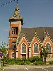 The church of Angres | |
 Coat of arms | |
Location of Angres 
| |
 Angres  Angres | |
| Coordinates: 50°24′35″N 2°45′33″E | |
| Country | France |
| Region | Hauts-de-France |
| Department | Pas-de-Calais |
| Arrondissement | Lens |
| Canton | Bully-les-Mines |
| Intercommunality | Communaupole de Lens-Liévin |
| Government | |
| • Mayor (2014-2020) | Maryse Coupin-Roger |
| Area 1 | 4.82 km2 (1.86 sq mi) |
| Population (2017-01-01)[1] | 4,526 |
| • Density | 940/km2 (2,400/sq mi) |
| Time zone | UTC+01:00 (CET) |
| • Summer (DST) | UTC+02:00 (CEST) |
| INSEE/Postal code | 62032 /62143 |
| Elevation | 49–106 m (161–348 ft) (avg. 54 m or 177 ft) |
| 1 French Land Register data, which excludes lakes, ponds, glaciers > 1 km2 (0.386 sq mi or 247 acres) and river estuaries. | |
Geography
A farming and light industrial suburb situated just 3 miles (4.8 km) southwest of Lens centre, at the junction of the D51 and D58e roads. The A26 autoroute passes by, just within the borders of the commune.
Population
| Historical population | ||
|---|---|---|
| Year | Pop. | ±% |
| 1962 | 3,993 | — |
| 1968 | 4,384 | +9.8% |
| 1975 | 4,538 | +3.5% |
| 1982 | 4,239 | −6.6% |
| 1990 | 4,394 | +3.7% |
| 1999 | 4,469 | +1.7% |
| 2005 | 4,508 | +0.9% |
| 2006 | 4,106 | −8.9% |
| 2007 | 4,054 | −1.3% |
| 2008 | 4,001 | −1.3% |
| 2009 | 3,982 | −0.5% |
| 2013 | 4,100 | +3.0% |
| 2014 | 4,202 | +2.5% |
| 2015 | 4,305 | +2.5% |
Sights
- The church of St. Cyr, rebuilt, as was most of the village, after the First World War.
- The war memorials.
International relations
Angres is twinned with:
![]()
External links
| Wikimedia Commons has media related to Angres. |
- Town council website (in French)
- Angres on the Quid website (in French)
- Website of the Communaupole de Lens-Liévin (in French)
| Authority control |
|
|---|
This article is issued from Wikipedia. The text is licensed under Creative Commons - Attribution - Sharealike. Additional terms may apply for the media files.