Oisy-le-Verger
Oisy-le-Verger is a commune in the Pas-de-Calais department in the Hauts-de-France region of France.
Oisy-le-Verger | |
|---|---|
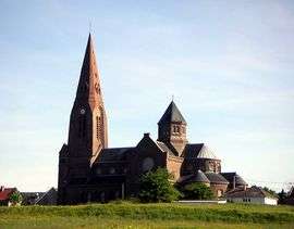 The church of Oisy-le-Verger | |
 Coat of arms | |
Location of Oisy-le-Verger 
| |
 Oisy-le-Verger  Oisy-le-Verger | |
| Coordinates: 50°15′03″N 3°07′29″E | |
| Country | France |
| Region | Hauts-de-France |
| Department | Pas-de-Calais |
| Arrondissement | Arras |
| Canton | Bapaume |
| Intercommunality | CC Osartis Marquion |
| Government | |
| • Mayor (2008–2014) | Jean-Pierre Léger |
| Area 1 | 11.36 km2 (4.39 sq mi) |
| Population (2017-01-01)[1] | 1,217 |
| • Density | 110/km2 (280/sq mi) |
| Time zone | UTC+01:00 (CET) |
| • Summer (DST) | UTC+02:00 (CEST) |
| INSEE/Postal code | 62638 /62860 |
| Elevation | 32–77 m (105–253 ft) (avg. 78 m or 256 ft) |
| 1 French Land Register data, which excludes lakes, ponds, glaciers > 1 km2 (0.386 sq mi or 247 acres) and river estuaries. | |
Geography
Oisy-le-Verger is a farming village situated 15 miles (24 km) east of Arras, at the junction of the D21 and D14 roads.
Population
| 1962 | 1968 | 1975 | 1982 | 1990 | 1999 | 2006 |
|---|---|---|---|---|---|---|
| 1303 | 1328 | 1310 | 1278 | 1301 | 1260 | 1297 |
| Census count starting from 1962: Population without duplicates | ||||||
Places of interest
- The church of St. Didier, dating from the twentieth century.
- Traces of an old castle and watermill.
- Remains of the Cistercian abbey founded in 1227.
- A pre-Roman menhir.
- The museum, housed in the mairie (town hall).

Town hall of Oisy-le-Verger
References
- "Populations légales 2017". INSEE. Retrieved 6 January 2020.
| Wikimedia Commons has media related to Oisy-le-Verger. |
| Authority control |
|
|---|
This article is issued from Wikipedia. The text is licensed under Creative Commons - Attribution - Sharealike. Additional terms may apply for the media files.