Moncheaux-lès-Frévent
Moncheaux-lès-Frévent is a commune in the Pas-de-Calais department in the Hauts-de-France region of France.
Moncheaux-lès-Frévent | |
|---|---|
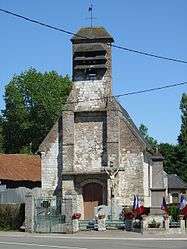 The church of Moncheaux-lès-Frévent | |
 Coat of arms | |
Location of Moncheaux-lès-Frévent 
| |
 Moncheaux-lès-Frévent  Moncheaux-lès-Frévent | |
| Coordinates: 50°18′54″N 2°22′02″E | |
| Country | France |
| Region | Hauts-de-France |
| Department | Pas-de-Calais |
| Arrondissement | Arras |
| Canton | Saint-Pol-sur-Ternoise |
| Intercommunality | CC Ternois |
| Government | |
| • Mayor (2008–2014) | Geneviève Grardel |
| Area 1 | 3.92 km2 (1.51 sq mi) |
| Population (2017-01-01)[1] | 139 |
| • Density | 35/km2 (92/sq mi) |
| Time zone | UTC+01:00 (CET) |
| • Summer (DST) | UTC+02:00 (CEST) |
| INSEE/Postal code | 62576 /62270 |
| Elevation | 128–153 m (420–502 ft) (avg. 137 m or 449 ft) |
| 1 French Land Register data, which excludes lakes, ponds, glaciers > 1 km2 (0.386 sq mi or 247 acres) and river estuaries. | |
Geography
Moncheaux-lès-Frévent is situated 20 miles (32 km) west of Arras, at the junction of the D82 and the D23 roads.
Population
| 1962 | 1968 | 1975 | 1982 | 1990 | 1999 | 2006 |
|---|---|---|---|---|---|---|
| 182 | 155 | 138 | 107 | 109 | 112 | 133 |
| Census count starting from 1962: Population without duplicates | ||||||
Places of interest
- The church of St.Martin, dating from the eighteenth century.
- Two 17th century manor houses.
References
- "Populations légales 2017". INSEE. Retrieved 6 January 2020.
| Wikimedia Commons has media related to Moncheaux-lès-Frévent. |
| Authority control |
|
|---|
This article is issued from Wikipedia. The text is licensed under Creative Commons - Attribution - Sharealike. Additional terms may apply for the media files.