Évin-Malmaison
Évin-Malmaison is a commune in the Pas-de-Calais department in the Hauts-de-France region of France.
Évin-Malmaison | |
|---|---|
 The church of Évin-Malmaison | |
 Coat of arms | |
Location of Évin-Malmaison 
| |
 Évin-Malmaison  Évin-Malmaison | |
| Coordinates: 50°26′20″N 3°02′03″E | |
| Country | France |
| Region | Hauts-de-France |
| Department | Pas-de-Calais |
| Arrondissement | Lens |
| Canton | Hénin-Beaumont-2 |
| Intercommunality | CA Hénin-Carvin |
| Government | |
| • Mayor (2008–2014) | Bernard Staszewski |
| Area 1 | 4.57 km2 (1.76 sq mi) |
| Population (2017-01-01)[1] | 4,551 |
| • Density | 1,000/km2 (2,600/sq mi) |
| Time zone | UTC+01:00 (CET) |
| • Summer (DST) | UTC+02:00 (CEST) |
| INSEE/Postal code | 62321 /62141 |
| Elevation | 21–31 m (69–102 ft) (avg. 26 m or 85 ft) |
| 1 French Land Register data, which excludes lakes, ponds, glaciers > 1 km2 (0.386 sq mi or 247 acres) and river estuaries. | |
Geography
An ex-coalmining village, now centred on farming and light industry, situated some 10 miles (16.1 km) east of Lens, at the junction of the D161 and the D54. The canalised Deule river forms the south-western boundary of the commune.
Population
| Year | 1962 | 1968 | 1975 | 1982 | 1990 | 1999 | 2004 |
|---|---|---|---|---|---|---|---|
| Population | 4022 | 4437 | 4388 | 4121 | 4934 | 4731 | 4758 |
| From the year 1962 on: No double counting—residents of multiple communes (e.g. students and military personnel) are counted only once. | |||||||
Places of interest
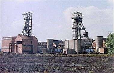
The two pit heads at Évin-Malmaison (c.1980s)
- The church of St.Vaast, dating from the sixteenth century.
- The war memorial.
- Remains of an 18th-century priory.
References
External links
| Wikimedia Commons has media related to Évin-Malmaison. |
- Official commune website (in French)
- Évin-Malmaison on the Quid website (in French)
| Authority control |
|
|---|
- "Populations légales 2017". INSEE. Retrieved 6 January 2020.
This article is issued from Wikipedia. The text is licensed under Creative Commons - Attribution - Sharealike. Additional terms may apply for the media files.