Monchy-Breton
Monchy-Breton is a commune in the Pas-de-Calais department in the Hauts-de-France region of France.
Monchy-Breton | |
|---|---|
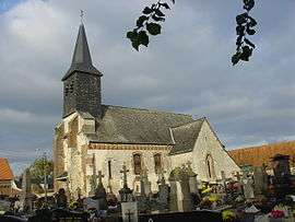 The church of Monchy-Breton | |
 Coat of arms | |
Location of Monchy-Breton 
| |
 Monchy-Breton  Monchy-Breton | |
| Coordinates: 50°24′06″N 2°26′45″E | |
| Country | France |
| Region | Hauts-de-France |
| Department | Pas-de-Calais |
| Arrondissement | Arras |
| Canton | Saint-Pol-sur-Ternoise |
| Intercommunality | CC Ternois |
| Government | |
| • Mayor (2008–2014) | Michel Derache |
| Area 1 | 6.9 km2 (2.7 sq mi) |
| Population (2017-01-01)[1] | 476 |
| • Density | 69/km2 (180/sq mi) |
| Time zone | UTC+01:00 (CET) |
| • Summer (DST) | UTC+02:00 (CEST) |
| INSEE/Postal code | 62580 /62127 |
| Elevation | 111–162 m (364–531 ft) (avg. 146 m or 479 ft) |
| 1 French Land Register data, which excludes lakes, ponds, glaciers > 1 km2 (0.386 sq mi or 247 acres) and river estuaries. | |
Geography
Monchy-Breton is situated 11 miles (18 km) northwest of Arras, at the junction of the D77 and the D86 roads.
Population
| 1962 | 1968 | 1975 | 1982 | 1990 | 1999 | 2006 |
|---|---|---|---|---|---|---|
| 353 | 390 | 352 | 351 | 388 | 389 | 413 |
| Census count starting from 1962: Population without duplicates. | ||||||
Places of interest
- The church of St. Hilaire, dating from the fifteenth century.
References
- "Populations légales 2017". INSEE. Retrieved 6 January 2020.
| Wikimedia Commons has media related to Monchy-Breton. |
| Authority control |
|
|---|
This article is issued from Wikipedia. The text is licensed under Creative Commons - Attribution - Sharealike. Additional terms may apply for the media files.