Lorgies
Lorgies is a commune in the Pas-de-Calais department in the Hauts-de-France region of France.
Lorgies | |
|---|---|
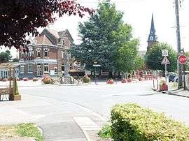 The centre of Lorgies | |
 Coat of arms | |
Location of Lorgies 
| |
 Lorgies  Lorgies | |
| Coordinates: 50°34′08″N 2°47′29″E | |
| Country | France |
| Region | Hauts-de-France |
| Department | Pas-de-Calais |
| Arrondissement | Béthune |
| Canton | Douvrin |
| Intercommunality | CA Béthune-Bruay, Artois-Lys Romane |
| Government | |
| • Mayor (2008–2014) | Anne-Marie Lefebvre |
| Area 1 | 6.84 km2 (2.64 sq mi) |
| Population (2017-01-01)[1] | 1,586 |
| • Density | 230/km2 (600/sq mi) |
| Time zone | UTC+01:00 (CET) |
| • Summer (DST) | UTC+02:00 (CEST) |
| INSEE/Postal code | 62529 /62840 |
| Elevation | 19–26 m (62–85 ft) (avg. 21 m or 69 ft) |
| 1 French Land Register data, which excludes lakes, ponds, glaciers > 1 km2 (0.386 sq mi or 247 acres) and river estuaries. | |
Geography
Lorgies is situated some 12 miles (19.3 km) northeast of Béthune and 13 miles (20.9 km) southwest of Lille, at the junction of the D168 and D72 roads.
Population
| 1962 | 1968 | 1975 | 1982 | 1990 | 1999 | 2006 |
|---|---|---|---|---|---|---|
| 834 | 858 | 853 | 922 | 1142 | 1174 | 1499 |
| Census count starting from 1962: Population without duplicates | ||||||
Places of interest
- The church of St. Mathieu, rebuilt in 1931.
- Le Bourg chapel.
External links
| Wikimedia Commons has media related to Lorgies. |
| Authority control |
|
|---|
This article is issued from Wikipedia. The text is licensed under Creative Commons - Attribution - Sharealike. Additional terms may apply for the media files.