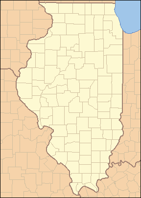
List of counties in Illinois
| Counties of Illinois | |
|---|---|
 | |
| Location | State of Illinois |
| Number | 102 |
| Populations | 4,836 (Hardin) – 5,194,675 (Cook) |
| Areas | 160 square miles (410 km2) (Putnam) – 1,184 square miles (3,070 km2) (McLean) |
| Government | County government |
| Subdivisions |
261 Precincts 1,433 Townships |
There are 102 counties in the State of Illinois.
Most counties in Illinois were named after early American leaders, especially of the American Revolutionary War, as well as soldiers from the Battle of Tippecanoe and the War of 1812. Some are named after natural features or counties in other states. Some are named for early Illinois leaders. Two counties are named for Native American tribes, and one bears the name of a plant used as a food source by Native Americans. Before the American Revolution, Illinois was part of the French Illinois Country, and then the British Province of Quebec. During the revolution it was claimed as part of Illinois County, Virginia. It became part of the Northwest Territory in 1787 (its first county still in existence, St. Clair County, was established in 1790), the area then became part of the Indiana Territory, and subsequently the Illinois Territory. Illinois gained statehood in 1818. By that year, 15 of its counties had been established, and subsequent counties would generally be formed from these fifteen. Ford County was the last, created in 1859.
While it does have a Lincoln city, Illinois does not have county named after its favorite son, Abraham Lincoln; it does, however, have a Douglas County (founded 1859) named after his political rival Stephen A. Douglas. It also has Calhoun County (founded 1825), named after John C. Calhoun, outspoken for his pro-slavery and pro-southern views in the years preceding the American Civil War. Several of the counties are named after Southerners, reflecting the fact that Illinois was for a short time part of Virginia, and settled in its early years by many Southerners. No counties are named after heroes of the Civil War, mainly because the counties were all named before that war. The state does have a Lee County (founded 1839) named after the family of Robert E. Lee, who at one time served in Illinois. Illinois also has two counties named after the same person, New York governor DeWitt Clinton (DeWitt County, and Clinton County).
Information on the FIPS county code, county seat, year of establishment, origin, etymology, population, area and map of each county is included in the table below.
Illinois's postal abbreviation is IL and its FIPS state code is 17.
Counties
Note: the links in the FIPS County Code column are to the Census Bureau info page for that county.
| County |
FIPS code[1] | County seat[2] | Established[2] | Origin | Etymology[3][4] | Population[2] | Area[2] | Map |
|---|---|---|---|---|---|---|---|---|
| Adams County | 001 | Quincy | 1825 | Pike County | John Quincy Adams (1767–1848), sixth President of the United States | 67,103 | 857 sq mi (2,220 km2) | 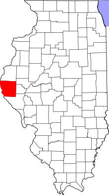 |
| Alexander County | 003 | Cairo | 1819 | Union County | William M. Alexander, settler and state representative in the Illinois General Assembly | 8,238 | 236 sq mi (611 km2) | 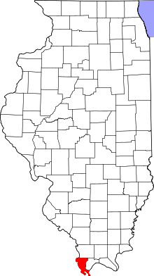 |
| Bond County | 005 | Greenville | 1817 | Crawford County, Edwards County, and Madison County | Shadrach Bond (1773–1832), first Governor of Illinois | 17,768 | 380 sq mi (984 km2) | 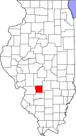 |
| Boone County | 007 | Belvidere | 1837 | Winnebago County | Daniel Boone (1734–1820), trailblazer of the Wilderness Road in Kentucky | 54,165 | 281 sq mi (728 km2) | 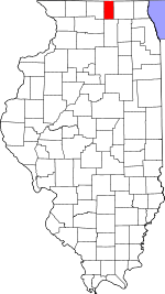 |
| Brown County | 009 | Mount Sterling | 1839 | Schuyler County | Jacob Brown (1775–1828), successful War of 1812 army officer responsible for Great Lakes defenses | 6,937 | 306 sq mi (793 km2) | 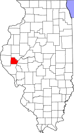 |
| Bureau County | 011 | Princeton | 1837 | Putnam County | Pierre de Bureo, Frenchman, North American fur trader | 34,978 | 869 sq mi (2,251 km2) | 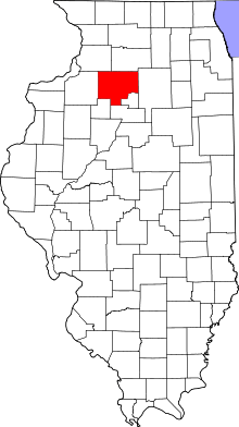 |
| Calhoun County | 013 | Hardin | 1825 | Pike County | John C. Calhoun (1782–1850), South Carolina senator and seventh Vice President of the United States | 5,089 | 254 sq mi (658 km2) | 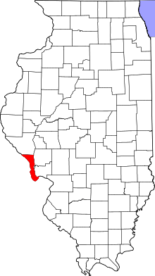 |
| Carroll County | 015 | Mount Carroll | 1839 | Jo Daviess | Charles Carroll of Carrollton (1737–1832), signed the Declaration of Independence on behalf of Maryland | 15,387 | 444 sq mi (1,150 km2) | 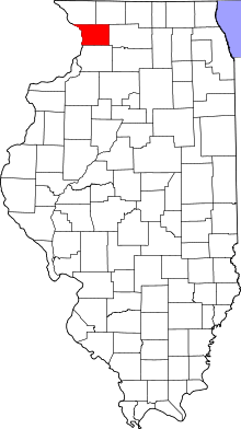 |
| Cass County | 017 | Virginia | 1837 | Morgan County | Lewis Cass (1782–1866), second governor of Michigan Territory, fourteenth United States Secretary of War | 13,642 | 376 sq mi (974 km2) | 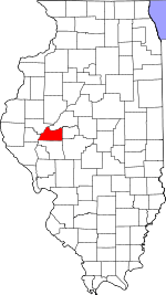 |
| Champaign County | 019 | Urbana | 1833 | Vermilion County | Champaign County, Ohio, which took its name from the French for "open level country" | 201,081 | 997 sq mi (2,582 km2) | 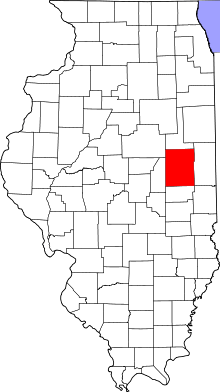 |
| Christian County | 021 | Taylorville | 1839 | Sangamon County | Christian County, Kentucky, which was itself named after Colonel William Christian | 34,800 | 709 sq mi (1,836 km2) | 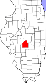 |
| Clark County | 023 | Marshall | 1819 | Crawford County | George Rogers Clark (1752–1818), highest-ranking officer in the Northwest Territory during the American Revolution | 16,335 | 502 sq mi (1,300 km2) | 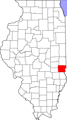 |
| Clay County | 025 | Louisville | 1824 | Wayne, Lawrence, Fayette, and Crawford County | Henry Clay (1777–1852), Kentucky legislator who negotiated the Missouri Compromise | 13,815 | 469 sq mi (1,215 km2) | 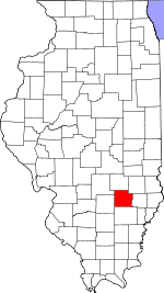 |
| Clinton County | 027 | Carlyle | 1824 | Washington, Bond, and Fayette County | DeWitt Clinton (1769–1828), Governor of New York, responsible for the construction of the Erie Canal | 37,762 | 474 sq mi (1,228 km2) | 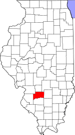 |
| Coles County | 029 | Charleston | 1830 | Clark and Edgar County | Edward Coles (1786–1868), second Governor of Illinois, responsible for the abolition of slavery in Illinois | 53,873 | 508 sq mi (1,316 km2) | 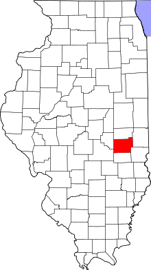 |
| Cook County | 031 | Chicago | 1831 | Putnam County | Daniel Pope Cook (1794–1827), politician and first Attorney General of Illinois | 5,194,675 | 946 sq mi (2,450 km2) | 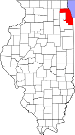 |
| Crawford County | 033 | Robinson | 1816 | Edwards County | William H. Crawford (1772–1834), ninth United States Secretary of War, seventh Secretary of the Treasury | 19,817 | 444 sq mi (1,150 km2) | 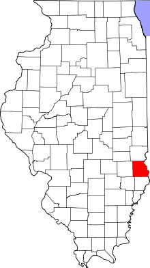 |
| Cumberland County | 035 | Toledo | 1843 | Coles County | Disputed: Cumberland Road, which entered the county; Cumberland, Maryland; or Cumberland River in Kentucky | 11,048 | 346 sq mi (896 km2) | 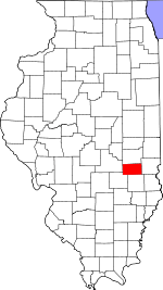 |
| DeKalb County | 037 | Sycamore | 1837 | Kane County | Johann de Kalb (1721–1780), German soldier in the Continental Army who fought alongside Gilbert du Motier, marquis de Lafayette | 105,160 | 634 sq mi (1,642 km2) | 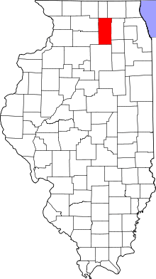 |
| DeWitt County | 039 | Clinton | 1839 | Macon and McLean County | DeWitt Clinton (1769–1828), Governor of New York, responsible for the construction of the Erie Canal | 16,561 | 398 sq mi (1,031 km2) | 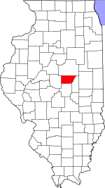 |
| Douglas County | 041 | Tuscola | 1859 | Coles County | Stephen A. Douglas (1813–61), prominent Illinois Democrat who engaged in debates with Abraham Lincoln | 19,980 | 417 sq mi (1,080 km2) | 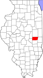 |
| DuPage County | 043 | Wheaton | 1839 | Cook County | DuPage River | 916,924 | 334 sq mi (865 km2) |  |
| Edgar County | 045 | Paris | 1823 | Clark County | John Edgar (c. 1750–1832), Illinois delegate to the Northwest Territory legislature; at the time, wealthiest man in Illinois | 18,576 | 624 sq mi (1,616 km2) |  |
| Edwards County | 047 | Albion | 1814 | Gallatin County and Madison County | Ninian Edwards (1775–1833), third Governor of the State of Illinois and only governor of the Illinois Territory | 6,721 | 222 sq mi (575 km2) | 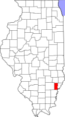 |
| Effingham County | 049 | Effingham | 1831 | Fayette and Crawford County | Thomas Howard, 3rd Earl of Effingham, military officer who resigned from the British Army to avoid fighting the American colonies | 34,242 | 479 sq mi (1,241 km2) | 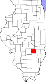 |
| Fayette County | 051 | Vandalia | 1821 | Bond, Wayne, Clark, Jefferson, and Crawford County | Gilbert du Motier, marquis de Lafayette (1757–1834), French military officer who was a key factor in the American and French Revolutions. | 22,140 | 716 sq mi (1,854 km2) | 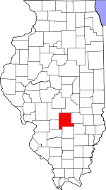 |
| Ford County | 053 | Paxton | 1859 | Vermilion County | Thomas Ford (1800–50), eighth Governor of Illinois; served during the Illinois Mormon War | 14,081 | 486 sq mi (1,259 km2) | 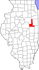 |
| Franklin County | 055 | Benton | 1818 | White County and Gallatin County | Benjamin Franklin (1706–90), prolific writer, inventor, and politician; key factor in the American Revolution | 39,561 | 412 sq mi (1,067 km2) | 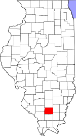 |
| Fulton County | 057 | Lewistown | 1823 | Pike County | Robert Fulton (1765–1815), inventor of the steamboat | 37,069 | 866 sq mi (2,243 km2) | 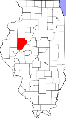 |
| Gallatin County | 059 | Shawneetown | 1812 | Randolph County | Albert Gallatin (1761–1849), fourth and longest-serving United States Secretary of the Treasury | 5,589 | 324 sq mi (839 km2) | 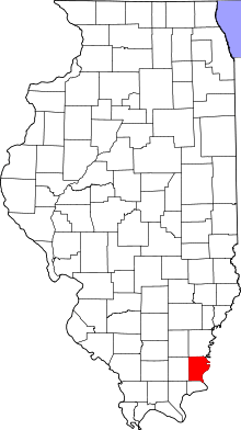 |
| Greene County | 061 | Carrollton | 1821 | Madison County | Nathanael Greene (1742–86), major general in the Continental Army | 13,886 | 543 sq mi (1,406 km2) | 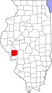 |
| Grundy County | 063 | Morris | 1841 | LaSalle County | Felix Grundy (1777–1840), Tennessean senator who served as the thirteenth United States Attorney General | 50,063 | 420 sq mi (1,088 km2) | 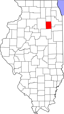 |
| Hamilton County | 065 | McLeansboro | 1821 | White County | Alexander Hamilton (1755–1804), first United States Secretary of the Treasury | 8,457 | 435 sq mi (1,127 km2) | 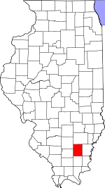 |
| Hancock County | 067 | Carthage | 1825 | Adams County | John Hancock (1737–93), first governor of the Massachusetts colony and president of the Second Continental Congress | 19,104 | 795 sq mi (2,059 km2) | 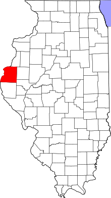 |
| Hardin County | 069 | Elizabethtown | 1839 | Pope County | Hardin County, Kentucky, which was itself named after John Hardin | 4,320 | 178 sq mi (461 km2) | 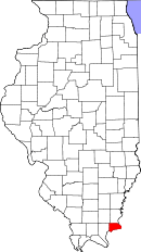 |
| Henderson County | 071 | Oquawka | 1841 | Warren County | Henderson County, Kentucky, which was itself named after Richard Henderson | 7,331 | 379 sq mi (982 km2) | 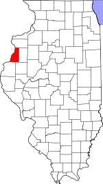 |
| Henry County | 073 | Cambridge | 1825 | Fulton County | Patrick Henry (1736-99), American Revolutionary War figure; first and sixth Governor of Virginia | 50,486 | 823 sq mi (2,132 km2) | 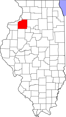 |
| Iroquois County | 075 | Watseka | 1833 | Vermilion County | Iroquois Native Americans | 29,718 | 1,116 sq mi (2,890 km2) | 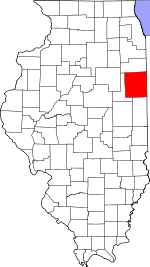 |
| Jackson County | 077 | Murphysboro | 1816 | Randolph County and Johnson County | Andrew Jackson (1767–1845), seventh President of the United States, United States Senator from Tennessee, and general in the War of 1812 | 60,218 | 588 sq mi (1,523 km2) | 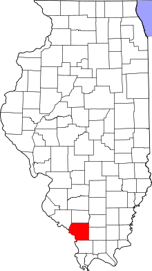 |
| Jasper County | 079 | Newton | 1831 | Clay and Crawford County | Sgt. William Jasper (c. 1750-79), American Revolutionary War soldier popularized by Parson Weems | 9,698 | 494 sq mi (1,279 km2) | 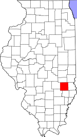 |
| Jefferson County | 081 | Mount Vernon | 1819 | Edwards and White County | Thomas Jefferson (1743–1826), third President of the United States, second Vice President of the United States, Governor of Virginia, and one of the foremost Founding Fathers of the United States | 38,827 | 571 sq mi (1,479 km2) | 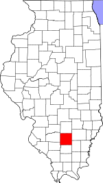 |
| Jersey County | 083 | Jerseyville | 1839 | Greene County | State of New Jersey, from which many early settlers hailed | 22,985 | 369 sq mi (956 km2) | 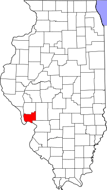 |
| Jo Daviess County | 085 | Galena | 1827 | Henry, Mercer, and Putnam County | Joseph Hamilton Daveiss (1774–1811), commander of the Indiana Dragoons at the Battle of Tippecanoe | 22,678 | 601 sq mi (1,557 km2) | 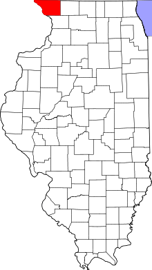 |
| Johnson County | 087 | Vienna | 1812 | Randolph County | Richard Mentor Johnson (abt. 1780-1850), ninth Vice President of the United States and United States Senator from Kentucky | 12,582 | 346 sq mi (896 km2) | 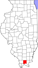 |
| Kane County | 089 | Geneva | 1836 | LaSalle County | Elias Kane (1794–1835), United States Senator from Illinois | 515,269 | 521 sq mi (1,349 km2) | 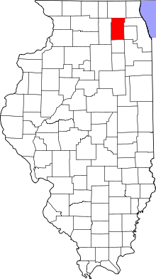 |
| Kankakee County | 091 | Kankakee | 1853 | Iroquois and Will County | Kankakee River | 113,449 | 678 sq mi (1,756 km2) | 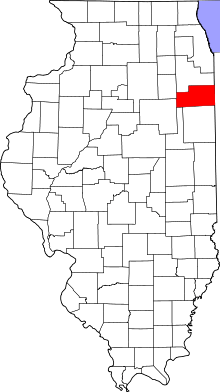 |
| Kendall County | 093 | Yorkville | 1841 | LaSalle and Kane County | Amos Kendall (1789–1869), United States Postmaster General under Presidents Andrew Jackson and Martin Van Buren | 114,736 | 321 sq mi (831 km2) | 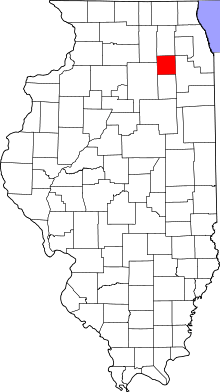 |
| Knox County | 095 | Galesburg | 1825 | Fulton County | Gen. Henry Knox (1750–1806), American Revolutionary War general and first United States Secretary of War | 52,919 | 716 sq mi (1,854 km2) | 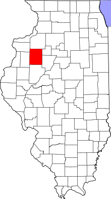 |
| Lake County | 097 | Waukegan | 1839 | McHenry County | Lake Michigan | 703,462 | 448 sq mi (1,160 km2) | 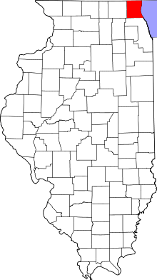 |
| LaSalle County | 099 | Ottawa | 1831 | Putnam and Tazewell County | Sieur de la Salle (1643-87), French explorer of the Great Lakes | 113,924 | 1,135 sq mi (2,940 km2) | 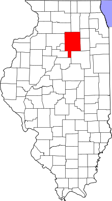 |
| Lawrence County | 101 | Lawrenceville | 1821 | Crawford and Edwards County | Capt. James Lawrence (1781–1813), commander of the USS Chesapeake in the War of 1812. Famous for his command "Don't give up the ship!" | 16,833 | 372 sq mi (963 km2) | 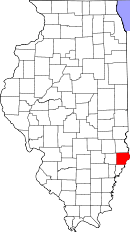 |
| Lee County | 103 | Dixon | 1839 | Ogle County | "Light Horse" Henry Lee III (1756–1818), American Revolutionary War officer and ninth Governor of Virginia | 36,031 | 725 sq mi (1,878 km2) | 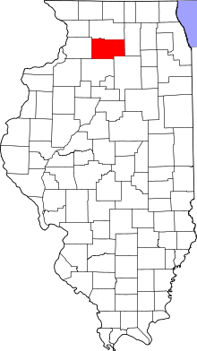 |
| Livingston County | 105 | Pontiac | 1837 | LaSalle and McLean County | Edward Livingston (1764–1836), prominent jurist, Congressman from New York and Louisiana, and U.S. Secretary of State from 1831-33 | 38,950 | 1,044 sq mi (2,704 km2) | 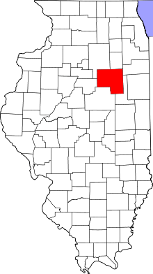 |
| Logan County | 107 | Lincoln | 1839 | Sangamon County | John Logan, country doctor and early settler, and the father of John A. Logan | 30,305 | 618 sq mi (1,601 km2) | 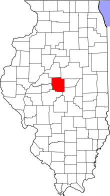 |
| Macon County | 115 | Decatur | 1829 | Shelby County | Nathaniel Macon (1758–1837), sixth Speaker of the United States House of Representatives and United States Senator from North Carolina | 110,768 | 581 sq mi (1,505 km2) | 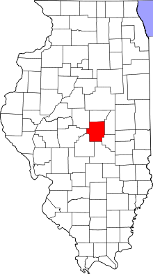 |
| Macoupin County | 117 | Carlinville | 1829 | Greene County | Native American word macoupin, meaning "American lotus" | 47,765 | 864 sq mi (2,238 km2) | 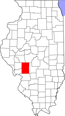 |
| Madison County | 119 | Edwardsville | 1812 | St. Clair County and Randolph County | James Madison (1751–1836), fourth President of the United States and principal author of the Constitution of the United States | 269,282 | 725 sq mi (1,878 km2) | 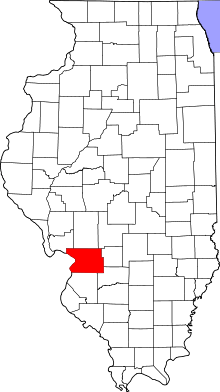 |
| Marion County | 121 | Salem | 1823 | Fayette and Jefferson County | Francis Marion (c. 1732-95), general in the American Revolutionary War known as "The Swamp Fox" | 39,437 | 572 sq mi (1,481 km2) | 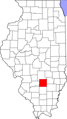 |
| Marshall County | 123 | Lacon | 1839 | Putnam County | John Marshall (1755–1835), fourth and longest-serving Chief Justice of the United States, wrote opinion in Marbury v. Madison establishing the principle of judicial review | 12,640 | 386 sq mi (1,000 km2) | 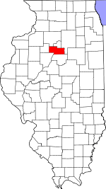 |
| Mason County | 125 | Havana | 1841 | Tazewell and Menard County | Named after Mason County, Kentucky, itself named after George Mason | 14,666 | 539 sq mi (1,396 km2) | 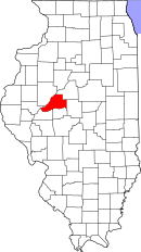 |
| Massac County | 127 | Metropolis | 1843 | Pope and Johnson County | Fort Massac, a colonial-era fort on the Ohio River | 15,429 | 239 sq mi (619 km2) |  |
| McDonough County | 109 | Macomb | 1826 | Schuyler County | Commodore Thomas Macdonough (1783–1825), commander of American naval forces at the Battle of Plattsburgh | 32,612 | 589 sq mi (1,526 km2) | 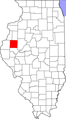 |
| McHenry County | 111 | Woodstock | 1836 | Cook and LaSalle County | Major William McHenry (c. 1771 – 1835), officer in during several campaigns against Native Americans and member of the Illinois legislature | 308,760 | 604 sq mi (1,564 km2) | 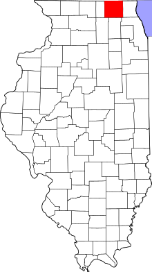 |
| McLean County | 113 | Bloomington | 1830 | Tazewell County | John McLean (1791–1830), United States Representative and United States Senator from Illinois (the latter from 1824-25 and 1829-30) | 169,572 | 1,184 sq mi (3,067 km2) | 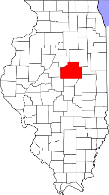 |
| Menard County | 129 | Petersburg | 1839 | Sangamon County | Pierre Menard (1766–1844), prominent early settler and first Lieutenant Governor of Illinois | 12,705 | 314 sq mi (813 km2) | 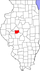 |
| Mercer County | 131 | Aledo | 1825 | Schuyler County | Hugh Mercer (1726-77), British officer in the Seven Years' War and general in the Continental Army during the American Revolutionary War | 16,434 | 561 sq mi (1,453 km2) | 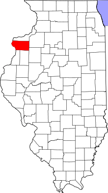 |
| Monroe County | 133 | Waterloo | 1816 | Randolph County and St. Clair County | James Monroe (1758–1831), seventh United States Secretary of State, eighth United States Secretary of War, Governor of Virginia, and fifth President of the United States | 32,957 | 388 sq mi (1,005 km2) | 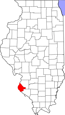 |
| Montgomery County | 135 | Hillsboro | 1821 | Bond and Madison County | Gen. Richard Montgomery (1738-75), brigadier-general in the Continental Army who led the unsuccessful invasion of Canada | 30,104 | 704 sq mi (1,823 km2) | 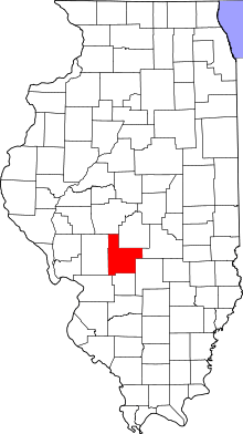 |
| Morgan County | 137 | Jacksonville | 1823 | Sangamon County | Gen. Daniel Morgan (1736–1802), successful tactician in the American Revolutionary War and later United States Representative from Virginia | 35,547 | 569 sq mi (1,474 km2) | 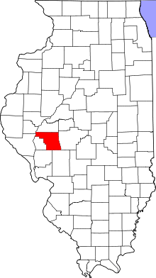 |
| Moultrie County | 139 | Sullivan | 1843 | Shelby and Macon County | Gen. William Moultrie (1730–1805), American Revolutionary War general and Governor of South Carolina | 14,846 | 336 sq mi (870 km2) | 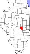 |
| Ogle County | 141 | Oregon | 1836 | Jo Daviess | Joseph Ogle (1737–1821), early settler in southwest Illinois, who helped found the first Methodist church in Illinois | 53,497 | 759 sq mi (1,966 km2) | 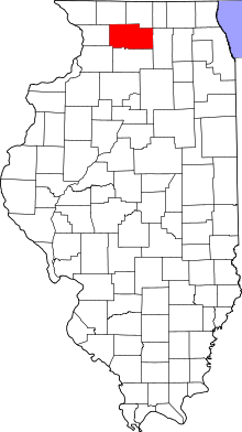 |
| Peoria County | 143 | Peoria | 1825 | Fulton County | The Peoria Native American tribe | 186,494 | 620 sq mi (1,606 km2) | 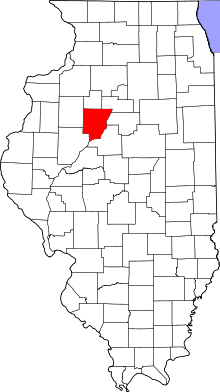 |
| Perry County | 145 | Pinckneyville | 1827 | Randolph and Jackson County | Commodore Oliver Hazard Perry (1785–1819), American naval officer who led the victorious American forces at the Battle of Lake Erie | 22,350 | 441 sq mi (1,142 km2) | 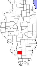 |
| Piatt County | 147 | Monticello | 1841 | DeWitt and Macon County | John Piatt, the patriarch of a prominent settler family in the early history of the county | 16,729 | 440 sq mi (1,140 km2) | 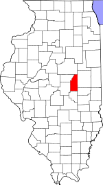 |
| Pike County | 149 | Pittsfield | 1821 | Madison, Bond, and Clark County | Zebulon Pike (1779–1813), early explorer of the American Southwest, namesake of Pikes Peak | 16,430 | 830 sq mi (2,150 km2) | 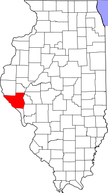 |
| Pope County | 151 | Golconda | 1816 | Gallatin and Johnson County | Nathaniel Pope (1784–1850), early Delegate from Illinois Territory to Congress and judge on the United States District Court for the District of Illinois | 4,470 | 371 sq mi (961 km2) | 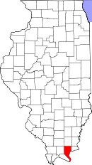 |
| Pulaski County | 153 | Mound City | 1843 | Alexander and Johnson County | Gen. Casimir Pulaski (1745-79), Polish American general of cavalry in the American Revolutionary War | 6,161 | 201 sq mi (521 km2) | 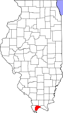 |
| Putnam County | 155 | Hennepin | 1825 | Fulton County | Gen. Israel Putnam (1718-90), commander of American forces at the Battle of Bunker Hill | 6,006 | 160 sq mi (414 km2) |  |
| Randolph County | 157 | Chester | 1795 | St. Clair County | Edmund Randolph (1753–1813), first Attorney General of the United States, and briefly United States Secretary of State | 33,476 | 578 sq mi (1,497 km2) | 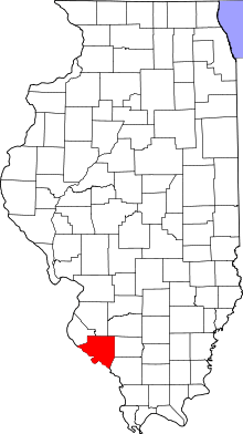 |
| Richland County | 159 | Olney | 1841 | Clay and Lawrence County | Richland County, Ohio, itself named for its rich soil | 16,233 | 360 sq mi (932 km2) | 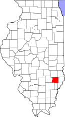 |
| Rock Island County | 161 | Rock Island | 1831 | Jo Daviess County | Rock Island | 147,546 | 427 sq mi (1,106 km2) | 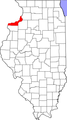 |
| Saline County | 165 | Harrisburg | 1847 | Gallatin County | Salt springs within the county | 24,913 | 383 sq mi (992 km2) | 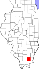 |
| Sangamon County | 167 | Springfield | 1821 | Madison and Bond County | Sangamon River | 197,465 | 868 sq mi (2,248 km2) | 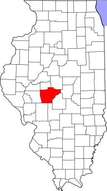 |
| Schuyler County | 169 | Rushville | 1825 | Pike and Fulton County | Gen. Philip Schuyler (1733–1804), American Revolutionary War general and United States Senator from New York | 7,544 | 437 sq mi (1,132 km2) | 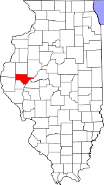 |
| Scott County | 171 | Winchester | 1839 | Morgan County | Scott County, Kentucky, itself named after Charles Scott | 5,355 | 251 sq mi (650 km2) | 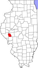 |
| Shelby County | 173 | Shelbyville | 1827 | Fayette County | Isaac Shelby (1750–1826), soldier in the American Revolutionary War and War of 1812; first and fifth Governor of Kentucky | 22,363 | 759 sq mi (1,966 km2) | 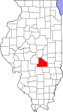 |
| St. Clair County | 163 | Belleville | 1790 | original two counties | Arthur St. Clair (1737–1818), major general in the American Revolutionary War and first Governor of the Northwest Territory | 270,056 | 664 sq mi (1,720 km2) | 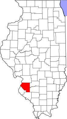 |
| Stark County | 175 | Toulon | 1839 | Knox and Putnam County | Gen. John Stark (1728–1822), general in the American Revolutionary War, called the "Hero of Bennington" | 5,994 | 288 sq mi (746 km2) | 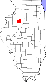 |
| Stephenson County | 177 | Freeport | 1837 | Jo Daviess and Winnebago County | Benjamin Stephenson (1769–1822), representative of Illinois Territory in the United States Congress from 1814 to 1816 | 47,711 | 564 sq mi (1,461 km2) | 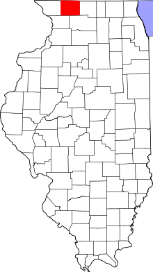 |
| Tazewell County | 179 | Pekin | 1827 | Sangamon County | Littleton Waller Tazewell (1774–1860), United States Senator from (and later governor of) Virginia | 135,394 | 649 sq mi (1,681 km2) | 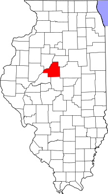 |
| Union County | 181 | Jonesboro | 1818 | Johnson County | The federal union of the states | 17,808 | 416 sq mi (1,077 km2) | 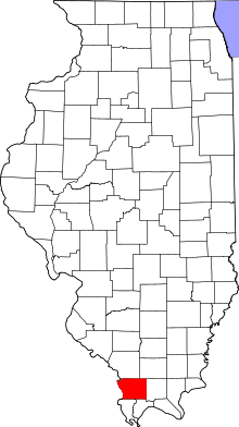 |
| Vermilion County | 183 | Danville | 1826 | Edgar County | The Vermilion River | 81,625 | 899 sq mi (2,328 km2) | 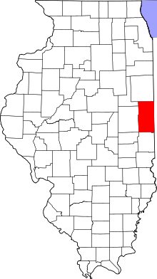 |
| Wabash County | 185 | Mount Carmel | 1824 | Edwards County | The Wabash River | 11,947 | 224 sq mi (580 km2) | 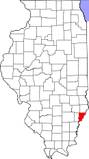 |
| Warren County | 187 | Monmouth | 1825 | Schuyler County | Joseph Warren (1741-75), played a role in American Patriot movements, a prominent early fatality in the American Revolutionary War | 17,707 | 543 sq mi (1,406 km2) | 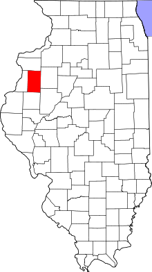 |
| Washington County | 189 | Nashville | 1818 | St. Clair County | George Washington (1732-99), commander-in-chief of American forces in the American Revolutionary War and first President of the United States | 14,716 | 563 sq mi (1,458 km2) |  |
| Wayne County | 191 | Fairfield | 1819 | Edwards County | Gen. "Mad" Anthony Wayne (1745-96), major general in the United States Army in the American Revolutionary War and the Northwest Indian War | 16,760 | 714 sq mi (1,849 km2) | 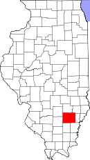 |
| White County | 193 | Carmi | 1815 | Gallatin County | Isaac White (1776–1811), resident of Illinois who enlisted in the Indiana militia and was killed at the Battle of Tippecanoe | 14,665 | 495 sq mi (1,282 km2) | 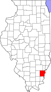 |
| Whiteside County | 195 | Morrison | 1836 | Jo Daviess and Henry County | Samuel Whiteside (1783–1868), state legislator and militia leader | 58,498 | 685 sq mi (1,774 km2) | 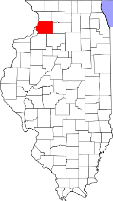 |
| Will County | 197 | Joliet | 1836 | Cook and Iroquois County | Conrad Will (1779–1835),[5] physician, local businessman and longtime member of the state legislature | 677,560 | 837 sq mi (2,168 km2) | 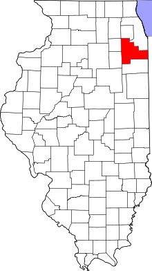 |
| Williamson County | 199 | Marion | 1839 | Franklin County | Hugh Williamson (1735–1819), delegate from North Carolina to the Philadelphia Convention | 66,357 | 424 sq mi (1,098 km2) | 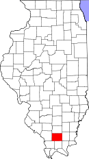 |
| Winnebago County | 201 | Rockford | 1836 | Jo Daviess | Winnebago Native Americans | 295,266 | 514 sq mi (1,331 km2) | 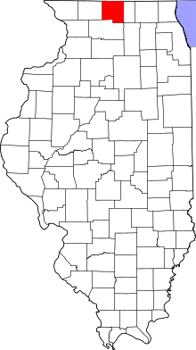 |
| Woodford County | 203 | Eureka | 1841 | Tazewell and McLean County | Gen. William Woodford (1734-80), brigadier general in the American Revolutionary War who died while a British prisoner | 38,664 | 528 sq mi (1,368 km2) | 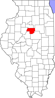 |
Defunct counties
- Dane County was renamed in 1840 to the current Christian County.
- The original Knox County, Illinois, became extinct with the formation of the Illinois Territory in 1809 - or, more precisely, it became Knox County, Indiana. The modern Knox County, Illinois was formed much later and was not a part of the original Knox County.
See also
- List of census-designated places in Illinois
- List of cities in Illinois
- List of Illinois townships
- List of precincts in Illinois
- List of towns and villages in Illinois
- List of unincorporated communities in Illinois
- National Association of Counties
- National Register of Historic Places listings in Illinois
Notes
- ↑ "EPA County FIPS Code Listing". EPA.gov. Archived from the original on 2008-02-16. Retrieved 2008-02-23.
- 1 2 3 4 "Find a county". National Association of Counties. Retrieved 2012-09-26.
- ↑ "Illinois County Biographies". Genealogy Trails.com. Genealogy Trails. 2000. Retrieved 2008-09-21.
- ↑ "The Origin of Illinois County Names". Genealogy Trails.com. Genealogy Trails. 2000. Retrieved 2008-09-21.
- ↑ Matile, Roger (22 June 2006). "Reflections: Was Dr. Conrad Will really worth his salt?". Ledger-Sentinel. Retrieved 11 October 2011.
References
- Hébert, Michael L. (2012). "Illinois County Boundaries: 1790 - Present". ILGenWeb.
- White, Jesse (March 2010). "Origin and Evolution of Illinois Counties" (PDF). Illinois Secretary of State.
External links
| Wikimedia Commons has media related to Counties in Illinois. |
- Census 2000 U.S. Gazetteer Files
- Illinois Association of County Board Members
- Illinois Association of County Officials
- Illinois City/County Management Association
