Boone County, Illinois
| Boone County, Illinois | |
|---|---|
.jpg) Floyd Hopkins Block in the Belvidere North State Street Historic District | |
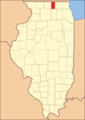
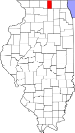 Location in the U.S. state of Illinois | |
 Illinois's location in the U.S. | |
| Founded | 1837 |
| Named for | Daniel Boone |
| Seat | Belvidere |
| Largest city | Belvidere |
| Area | |
| • Total | 288 sq mi (746 km2) |
| • Land | 286 sq mi (741 km2) |
| • Water | 2.3 sq mi (6 km2), 0.5% |
| Population | |
| • (2010) | 54,165 |
| • Density | 193/sq mi (75/km2) |
| Congressional district | 16th |
| Time zone | Central: UTC−6/−5 |
| Website |
www |
Boone County is a county located in the U.S. state of Illinois. As of the 2010 census, the population was 54,165.[1] Its county seat is Belvidere.[2]
Boone County is included in the Rockford, IL Metropolitan Statistical Area.
History
Boone County was formed in 1837 out of Winnebago County. It was named for Kentucky frontiersman Daniel Boone.[3] The first non-Native American settlers arrived in what is now Boone County in 1835. They arrived as a result of the end of the Black Hawk War as well as the completion of the Erie Canal. They consisted entirely of settlers from New England. These were "Yankee" settlers, that is to say they were descended from the English Puritans who settled New England in the colonial era. They were primarily members of the Congregational Church though due to the Second Great Awakening many of them had converted to Methodism and some had become Baptists before coming to what is now Boone County. When the New England settlers arrived in what is now Boone County there was nothing but a dense virgin forest and wild prairie. In the late 1870s immigrants began arriving from Germany and Ireland.[4]
 Boone County at the time of its creation in 1837
Geography
According to the U.S. Census Bureau, the county has a total area of 282 square miles (730 km2), of which 281 square miles (730 km2) is land and 1.3 square miles (3.4 km2) (0.5%) is water.[5]
Adjacent counties
- Rock County, Wisconsin - north
- Walworth County, Wisconsin - northeast
- McHenry County - east
- DeKalb County - south
- Ogle County - southwest
- Winnebago County - west
Major highways
Logan Avenue county route 40 Genoa Road (T-40) Garden Prairie Road county route 41 Poplar Grove Road county route 32 Capron Road (T-41)
Climate and weather
| Belvidere, Illinois | ||||||||||||||||||||||||||||||||||||||||||||||||||||||||||||
|---|---|---|---|---|---|---|---|---|---|---|---|---|---|---|---|---|---|---|---|---|---|---|---|---|---|---|---|---|---|---|---|---|---|---|---|---|---|---|---|---|---|---|---|---|---|---|---|---|---|---|---|---|---|---|---|---|---|---|---|---|
| Climate chart (explanation) | ||||||||||||||||||||||||||||||||||||||||||||||||||||||||||||
| ||||||||||||||||||||||||||||||||||||||||||||||||||||||||||||
| ||||||||||||||||||||||||||||||||||||||||||||||||||||||||||||
In recent years, average temperatures in the county seat of Belvidere have ranged from a low of 11 °F (−12 °C) in January to a high of 85 °F (29 °C) in July, although a record low of −29 °F (−34 °C) was recorded in January 1979 and a record high of 109 °F (43 °C) was recorded in July 1936. Average monthly precipitation ranged from 1.29 inches (33 mm) in February to 4.56 inches (116 mm) in June.[6]
Demographics

| Historical population | |||
|---|---|---|---|
| Census | Pop. | %± | |
| 1840 | 1,705 | — | |
| 1850 | 7,624 | 347.2% | |
| 1860 | 11,678 | 53.2% | |
| 1870 | 12,942 | 10.8% | |
| 1880 | 11,508 | −11.1% | |
| 1890 | 12,203 | 6.0% | |
| 1900 | 15,791 | 29.4% | |
| 1910 | 15,481 | −2.0% | |
| 1920 | 15,322 | −1.0% | |
| 1930 | 15,078 | −1.6% | |
| 1940 | 15,202 | 0.8% | |
| 1950 | 17,070 | 12.3% | |
| 1960 | 20,326 | 19.1% | |
| 1970 | 25,440 | 25.2% | |
| 1980 | 28,630 | 12.5% | |
| 1990 | 30,806 | 7.6% | |
| 2000 | 41,786 | 35.6% | |
| 2010 | 54,165 | 29.6% | |
| Est. 2016 | 53,503 | [7] | −1.2% |
| U.S. Decennial Census[8] 1790-1960[9] 1900-1990[10] 1990-2000[11] 2010-2013[1] | |||
As of the 2010 United States Census, there were 54,165 people, 18,505 households, and 14,273 families residing in the county.[12] The population density was 193.0 inhabitants per square mile (74.5/km2). There were 19,970 housing units at an average density of 71.1 per square mile (27.5/km2).[5] The racial makeup of the county was 84.4% white, 2.0% black or African American, 1.3% Asian, 0.4% American Indian, 9.3% from other races, and 2.6% from two or more races. Those of Hispanic or Latino origin made up 20.2% of the population.[12] In terms of ancestry, 25.6% were German, 13.7% were Irish, 9.2% were English, 8.6% were American, 7.7% were Italian, 7.1% were Swedish, and 5.0% were Polish.[13]
Of the 18,505 households, 41.5% had children under the age of 18 living with them, 61.6% were married couples living together, 10.2% had a female householder with no husband present, 22.9% were non-families, and 18.9% of all households were made up of individuals. The average household size was 2.91 and the average family size was 3.32. The median age was 36.8 years.[12]
The median income for a household in the county was $61,210 and the median income for a family was $69,380. Males had a median income of $53,581 versus $34,651 for females. The per capita income for the county was $26,105. About 7.9% of families and 10.4% of the population were below the poverty line, including 15.3% of those under age 18 and 5.0% of those age 65 or over.[14]
Education
- Belvidere Community Unit School District 100
- Harvard Community Unit School District 50
- Hiawatha Community Unit School District 426
- North Boone Community Unit School District 200
- Rockford School District 205
Communities
Cities
Villages
Census-designated places
Townships
Boone County is divided into these nine townships:
Politics
| Year | Republican | Democratic | Third Parties |
|---|---|---|---|
| 2016 | 53.4% 12,282 | 39.1% 8,986 | 7.5% 1,733 |
| 2012 | 51.8% 11,096 | 46.1% 9,883 | 2.2% 462 |
| 2008 | 46.8% 10,403 | 51.0% 11,333 | 2.3% 502 |
| 2004 | 57.0% 11,132 | 42.4% 8,286 | 0.6% 123 |
| 2000 | 55.5% 8,617 | 41.8% 6,481 | 2.7% 425 |
| 1996 | 47.5% 6,181 | 41.1% 5,345 | 11.4% 1,483 |
| 1992 | 41.0% 5,589 | 37.5% 5,114 | 21.5% 2,924 |
| 1988 | 61.7% 6,923 | 37.7% 4,234 | 0.6% 65 |
| 1984 | 66.7% 7,536 | 32.9% 3,717 | 0.5% 53 |
| 1980 | 57.7% 6,697 | 27.3% 3,175 | 15.0% 1,742 |
| 1976 | 58.4% 6,470 | 40.2% 4,458 | 1.4% 154 |
| 1972 | 68.9% 7,003 | 30.8% 3,131 | 0.3% 31 |
| 1968 | 62.3% 5,936 | 29.4% 2,801 | 8.4% 796 |
| 1964 | 57.8% 5,053 | 42.2% 3,694 | |
| 1960 | 71.5% 6,552 | 28.4% 2,605 | 0.1% 5 |
| 1956 | 78.0% 6,706 | 22.0% 1,890 | 0.1% 6 |
| 1952 | 74.2% 6,628 | 25.6% 2,287 | 0.2% 17 |
| 1948 | 71.4% 4,916 | 28.2% 1,941 | 0.4% 25 |
| 1944 | 73.2% 5,708 | 26.6% 2,074 | 0.2% 18 |
| 1940 | 73.3% 6,330 | 26.4% 2,277 | 0.3% 25 |
| 1936 | 67.0% 5,375 | 29.7% 2,383 | 3.3% 264 |
| 1932 | 69.2% 5,244 | 29.6% 2,239 | 1.2% 92 |
| 1928 | 81.0% 5,965 | 18.6% 1,371 | 0.5% 33 |
| 1924 | 75.4% 4,872 | 5.4% 348 | 19.3% 1,244 |
| 1920 | 89.4% 5,386 | 8.2% 496 | 2.4% 143 |
| 1916 | 77.6% 5,181 | 18.1% 1,211 | 4.3% 286 |
| 1912 | 37.0% 1,361 | 14.7% 540 | 48.4% 1,781 |
| 1908 | 76.1% 2,805 | 15.9% 587 | 8.0% 296 |
| 1904 | 84.7% 3,036 | 8.4% 302 | 6.9% 247 |
| 1900 | 79.6% 3,159 | 17.7% 704 | 2.7% 108 |
| 1896 | 80.9% 3,111 | 17.1% 657 | 2.0% 78 |
| 1892 | 73.8% 1,994 | 19.2% 518 | 7.0% 189 |
As a historic Yankee settlement, Boone County in its early years was a major base for the Free Soil Party, being one of nine Illinois counties to vote for Martin van Buren in 1848. Its Free Soil affinities meant Boone became one of the first strongholds of the Republican Party and remained overwhelmingly Republican for the following century, although it did vote for Progressive Theodore Roosevelt in 1912 when the Republican Party was severely split. Between at least 1892 and 1928 no Democratic Presidential candidate ever managed twenty percent of the county’s vote, and in the century up to 1960 no Democrat reached thirty percent – a degree of GOP loyalty comparable to such famous bastions as Owsley County in Kentucky, Grant County in West Virginia, or Avery County in North Carolina. Even Barry Goldwater, who alienated the Yankee Northeast so much as to lose all but one county there, still won Boone County by 15.6 percentage points, and between 1968 and 1988 no Democrat did better than Jimmy Carter’s 40.2 percent.
The shift of the Republican Party towards an expanded Southern and Western base, and particularly its growing strength with social conservatives, alienated the Yankee North during the 1990s and 2000s, but Boone County remained in Republican hands. The candidacy of Ross Perot in 1992 and 1996 caused George H. W. Bush and Bob Dole both to win Boone County with mere pluralities against Bill Clinton, and in 2008, Illinois resident Barack Obama became the only Democrat to carry the county since James K. Polk in 1844. The 2010s have seen a reversal of this Democratic trend due to concern over employment declines in the “Rust Belt“, so that Donald Trump’s 2016 showing was the best by a Republican since 1988.
See also
References
- 1 2 "State & County QuickFacts". United States Census Bureau. Retrieved July 3, 2014.
- ↑ "Find a County". National Association of Counties. Archived from the original on 2011-05-31. Retrieved 2011-06-07.
- ↑ History of the Origin of the Place Names in Nine Northwestern States. 1908. p. 12.
- ↑ The Past and Present of Boone County, Illinois. Chicago: H. F. Kett & Company, 1877, p. 226.
- 1 2 "Population, Housing Units, Area, and Density: 2010 - County". United States Census Bureau. Retrieved 2015-07-11.
- 1 2 "Monthly Averages for Belvidere, Illinois". The Weather Channel. Retrieved 2011-01-27.
- ↑ "Population and Housing Unit Estimates". Retrieved June 9, 2017.
- ↑ "U.S. Decennial Census". United States Census Bureau. Archived from the original on May 12, 2015. Retrieved July 3, 2014.
- ↑ "Historical Census Browser". University of Virginia Library. Retrieved July 3, 2014.
- ↑ "Population of Counties by Decennial Census: 1900 to 1990". United States Census Bureau. Retrieved July 3, 2014.
- ↑ "Census 2000 PHC-T-4. Ranking Tables for Counties: 1990 and 2000" (PDF). United States Census Bureau. Retrieved July 3, 2014.
- 1 2 3 "DP-1 Profile of General Population and Housing Characteristics: 2010 Demographic Profile Data". United States Census Bureau. Retrieved 2015-07-11.
- ↑ "DP02 SELECTED SOCIAL CHARACTERISTICS IN THE UNITED STATES – 2006-2010 American Community Survey 5-Year Estimates". United States Census Bureau. Retrieved 2015-07-11.
- ↑ "DP03 SELECTED ECONOMIC CHARACTERISTICS – 2006-2010 American Community Survey 5-Year Estimates". United States Census Bureau. Retrieved 2015-07-11.
- ↑ Leip, David. "Dave Leip's Atlas of U.S. Presidential Elections". uselectionatlas.org.
Further reading
- History of Boone County, Illinois. Salem, MA: Higginson Book Co., 1998.
- The Past and Present of Boone County, Illinois: Containing a History of the County — Its Cities, Towns, Etc.; A Biographical Directory of Its Citizens; War Record of Its Volunteers in the Late Rebellion; Portraits of Early Settlers and Prominent Men; General and Local Statistics; History of the Northwest; History of Illinois; Constitution of the United States; Map of Boone County; Miscellaneous Matters; Etc., Etc. Chicago: H.F. Kett and Co., 1877.
External links
- United States Census Bureau 2007 TIGER/Line Shapefiles
- United States Board on Geographic Names (GNIS)
- United States National Atlas
Coordinates: 42°20′N 88°49′W / 42.33°N 88.81°W
Places adjacent to Boone County, Illinois | ||||||||||
|---|---|---|---|---|---|---|---|---|---|---|
| ||||||||||
Municipalities and communities of Boone County, Illinois, United States | ||
|---|---|---|
| Cities | ||
| Villages | ||
| Townships | ||
| CDPs | ||
| Unincorporated communities | ||
| Ghost town | ||
| Footnotes | ‡This populated place also has portions in an adjacent county or counties | |
| Major city |  | |
|---|---|---|
| Cities (over 30,000 in 2010) | ||
| Towns and villages (over 30,000 in 2010) |
| |
| Counties | ||
| Regions | ||
| Sub-regions | ||
