Mundelein, Illinois
| Mundelein, Illinois | |
|---|---|
| Village | |
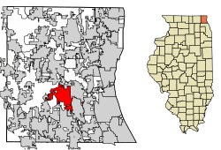 Location of Mundelein in Lake County, Illinois. | |
 Mundelein, Illinois Location of Mundelein in Lake County, Illinois. | |
| Coordinates: 42°16′N 88°0′W / 42.267°N 88.000°WCoordinates: 42°16′N 88°0′W / 42.267°N 88.000°W | |
| Country |
|
| State | Illinois |
| County | Lake |
| Township | Fremont |
| Incorporated | 1865 |
| Government | |
| • Type | Village |
| • Mayor | Steve Lentz |
| Area[1] | |
| • Total | 9.94 sq mi (25.75 km2) |
| • Land | 9.55 sq mi (24.73 km2) |
| • Water | 0.39 sq mi (1.01 km2) 4.02% |
| Population (2010) | |
| • Total | 31,064 |
| • Estimate (2016)[2] | 31,475 |
| • Density | 3,296.16/sq mi (1,272.65/km2) |
| Standard of living | |
| • Per capita income | $26,280 (median: $71,500) |
| ZIP code(s) | 60060 |
| Area code(s) | 847 and 224 |
| FIPS code | 17-51349 |
| Website |
www |
| Demographics (2000)[3] | |||
|---|---|---|---|
| White | Black | Hispanic | Asian |
| 76.68% | 1.60% | 24.20% | 6.60% |
| Islander | Native | Other | |
| 0.07% | 0.28% | 10.66% | |
Mundelein is a village in Lake County, Illinois, United States and a northern suburb of Chicago. As of the 2010 census, the village population was 31,064.[4] It is approximately thirty-five miles northwest of Chicago.
History
The community now known as Mundelein has been inhabited since at least 1650, when the Potawatomi people were known to have been trading with French fur traders. The first European inhabitants reached the area in the early 19th century. Peter Shaddle (for whom a street is named) was the first known settler, building a log cabin in the area now owned by St. Mary of the Lake Seminary in 1835.[5]
The next settlers were tradesmen escaping from England's industrial depression, who became farmers in the Mundelein area. In honor of their former professions, they named the city "Mechanics Grove", and built schools, churches, and businesses. The community grew and (while still unincorporated) changed its name to "Holcomb", in honor of John Holcomb, a person who was active in the area's development. As Holcomb, the community added a railway station and a post office. The Holcomb area incorporated in February 1909 under a new name, "Rockefeller", a reference to businessman John D. Rockefeller.
The name Rockefeller was short lived, however. In July 1909, the community became "Area". This name change was requested by a local educational entrepreneur named Arthur Sheldon, who bought 600 acres (2.4 km2) near town and built a school on it. The school taught sales techniques, including the philosophy of "AREA", which stood for "Ability, Reliability, Endurance, and Action." At one time, it boasted 10,000 students, many of them women (which was unusual for 1909).[6]
In 1915, Archbishop George Mundelein (later Cardinal) of Chicago purchased the property from Sheldon after the Area campus closed to re-establish the Archdiocese's University of Saint Mary of the Lake, also known as the Mundelein Seminary, which continues to exist today.[6]
On December 10, 1924, the Village Board held a special meeting with representatives from the Soo Line Railroad, who requested that the board change the village's name to Mundelein (for the cardinal). The board voted to make the change and asked the Illinois Secretary of State to make the name change. They received permission in April 1925, and the Village Board passed an ordinance changing the village's name to Mundelein. Cardinal Mundelein donated the village its first new fire truck, a 1925 Stoughton. The fire truck was officially turned over to the village at a ceremony held at the St. Mary of the Lake Seminary on July 17, 1925. The original Village Hall, built in 1929 with a few additions over the years, was used until June 2014.[7]
Geography
Mundelein is located at 42°15'47.0"N 88°00'14.4"W (42.263049, -88.004010).
According to the 2010 census, Mundelein has a total area of 9.969 square miles (25.82 km2), of which 9.57 square miles (24.79 km2) (or 96%) is land and 0.399 square miles (1.03 km2) (or 4%) is water.[8]
Demographics
| Historical population | |||
|---|---|---|---|
| Census | Pop. | %± | |
| 1910 | 358 | — | |
| 1920 | 420 | 17.3% | |
| 1930 | 1,011 | 140.7% | |
| 1940 | 1,328 | 31.4% | |
| 1950 | 3,189 | 140.1% | |
| 1960 | 10,526 | 230.1% | |
| 1970 | 16,128 | 53.2% | |
| 1980 | 17,053 | 5.7% | |
| 1990 | 21,215 | 24.4% | |
| 2000 | 30,935 | 45.8% | |
| 2010 | 31,064 | 0.4% | |
| Est. 2016 | 31,475 | [2] | 1.3% |
| U.S. Decennial Census[9] | |||
As of the census[10] of 2000, there were 30,935 people, 9,858 households, and 7,718 families residing in the village. The population density was 3,587.5 people per square mile (1,385.6/km²). There were 10,167 housing units at an average density of 1,179.0 per square mile (455.4/km²). The racial makeup of the village was 78.68% White, 1.60% Black, 0.28% Native American, 6.60% Asian, 0.07% Pacific Islander, 10.66% from other races, and 2.11% from two or more races. Hispanic or Latino of any race were 51.09% of the population.
There were 9,858 households out of which 47.2% had children under the age of 18 living with them, 65.0% were married couples living together, 9.0% had a female householder with no husband present, and 21.7% were non-families. 17.0% of all households were made up of individuals and 4.5% had someone living alone who was 65 years of age or older. The average household size was 3.12 and the average family size was 3.52.
In the village, the population was spread out with 31.4% under the age of 18, 8.3% from 18 to 24, 36.0% from 25 to 44, 18.1% from 45 to 64, and 6.2% who were 65 years of age or older. The median age was 32 years. For every 100 females, there were 104.6 males. For every 100 females age 18 and over, there were 103.6 males.
The median income for a household in the village was $69,651, and the median income for a family was $75,083 (these figures had risen to $80,556 and $85,656 respectively as of a 2007 estimate[11]). Males had a median income of $50,290 versus $34,087 for females. The per capita income for the village was $26,280. About 3.0% of families and 4.6% of the population were below the poverty line, including 5.2% of those under age 18 and 3.4% of those age 65 or over.
As of the 2010 US Census, there were 31,064 people residing in the village. The racial makeup of the village was 72.29% White, 1.52% African American, 0.65% Native American, 8.77% Asian, 0.03% Pacific Islander, 14.18% from other races, and 2.56% from two or more races. Hispanic or Latino of any race were 30.08% of the population.
Economy
Top employers
According to Mundelein's 2017 Comprehensive Annual Financial Report,[12] the top employers in the village are:
| # | Employer | # of Employees |
|---|---|---|
| 1 | Medline Industries | 900 |
| 2 | Accurate Transmissions | 320 |
| 3 | Amcor Flexible Healthcare, Inc. | 315 |
| 4 | Maclean-Fogg Co. | 240 |
| 5 | University of Saint Mary of the Lake | 220 |
| 6 | Mundelein Elementary School #75 | 220 |
| 7 | Mundelein High School #120 | 210 |
| 8 | Ruprecht Company | 200 |
| 9 | Village of Mundelein | 185 |
| 10 | Carter Hoffman Co. | 110 |
Neighborhoods
- Grand Dominion (Active Adult)
- Barnhill
- Diamond Lake
- Fields of Ambria
- Loch Lomond
- Sylvan Lake
- West Shore Park
- Countryside
- Cambridge Countryside
- Fairhaven
- Tullamore
- Ambria
- Cambridge Country
- Holcomb
- Cambridge Country North
- Hampton Reserve
- Long Meadow
- Woodhaven
- Colony Of Long Meadow
- Steeple Chase
- Lakewood Village
- Cambridge West
School districts
Four public school districts serve Mundelein residents:
Mundelein Elementary School District 75:
- Washington School - Grade Center PK-K-2
- Mechanics Grove School - 3-5
- Carl Sandburg Middle School - 6-8
Diamond Lake School District 76:
- Fairhaven School - PK-K-1
- Diamond Lake School - 2-4
- West Oak Middle School - 5-8
- Fremont Elementary School - K-2
- Fremont Intermediate School - 3-5
- Fremont Middle School - 6-8
Mundelein Consolidated High School District 120:
Additionally, the following parochial schools are located in Mundelein:
- Santa Maria del Popolo School (Catholic) - K-8 (Closed in 2014)
- St. Mary's of the Annunciation (Catholic) - K-8
- Carmel High School (Catholic)
School District 75 boundaries changed significantly in 2003-2004, in response to studies indicating sharp disparities in ethnic makeup among various schools in the district. This rebalancing has placed some boundaries through the middle of some houses, and made drawing lines very difficult to describe.
Transportation
Mundelein has a station on Metra's North Central Service, which provides weekday rail service between Antioch and Chicago Union Station.
A small private airport, Air Estates Airport, is located northwest of Mundelein.
Newspapers
- Mundelein Review (Pioneer Press)
- Mundelein News
- Daily Herald (Arlington Heights)
References
- ↑ "2016 U.S. Gazetteer Files". United States Census Bureau. Retrieved Jun 30, 2017.
- 1 2 "Population and Housing Unit Estimates". Retrieved June 9, 2017.
- ↑ 2000 United States Census Data
- ↑ "Geographic Identifiers: 2010 Demographic Profile Data (G001): Mundelein village, Illinois". U.S. Census Bureau, American Factfinder. Retrieved December 18, 2012.
- ↑ "Life of Peter Shaddle". Leaneagh Family History. Archived from the original on 27 January 2013. Retrieved 12 November 2012.
- 1 2 "Arthur Sheldon, 'Philosopher of Selling,' is dead". Chicago Tribune. 22 December 1935. Retrieved 18 September 2016.
- ↑ https://www.youtube.com/watch?v=o4Hj5w_6S6o
- ↑ "G001 - Geographic Identifiers - 2010 Census Summary File 1". United States Census Bureau. Retrieved 2015-12-19.
- ↑ "Census of Population and Housing". Census.gov. Retrieved June 4, 2015.
- ↑ "American FactFinder". United States Census Bureau. Retrieved 2008-01-31.
- ↑ Factfinder/census information
- ↑ "Village of Mundelein Comprehensive Annual Financial Report Year Ended April 30, 2017" (PDF). Village of Mundelein | Illinois Local Government Organization. 30 October 2017. Retrieved 9 June 2018.
External links
Places adjacent to Mundelein, Illinois | |
|---|---|
Municipalities and communities of Lake County, Illinois, United States | ||
|---|---|---|
| Cities | ||
| Villages |
| |
| Townships | ||
| CDPs | ||
| Other unincorporated communities | ||
| Former settlement | ||
| Footnotes | ‡This populated place also has portions in an adjacent county or counties | |
| Major city |  | |
|---|---|---|
| Cities (over 30,000 in 2010) | ||
| Towns and villages (over 30,000 in 2010) |
| |
| Counties | ||
| Regions | ||
| Sub-regions | ||