McHenry County, Illinois
| McHenry County, Illinois | ||
|---|---|---|
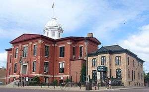 Old McHenry County Courthouse in Woodstock | ||
| ||
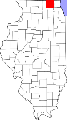 Location in the U.S. state of Illinois | ||
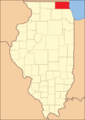
 Illinois's location in the U.S. | ||
| Founded | January 16th, 1836 [1] | |
| Named for | William McHenry | |
| Seat | Woodstock | |
| Largest city | Crystal Lake | |
| Area | ||
| • Total | 611 sq mi (1,582 km2) | |
| • Land | 603 sq mi (1,562 km2) | |
| • Water | 7.6 sq mi (20 km2), 1.3% | |
| Population (est.) | ||
| • (2015) | 307,343 | |
| • Density | 512/sq mi (198/km2) | |
| Congressional districts | 6th, 14th | |
| Time zone | Central: UTC−6/−5 | |
| Website |
www | |

McHenry County is a county located in the U.S. state of Illinois. According to the 2010 census, it had a population of 308,760,[2] making it the sixth-most populous county in Illinois. Its county seat is Woodstock.[3]
McHenry County is one of the five collar counties of the Chicago-Naperville-Elgin, IL-IN-WI Metropolitan Statistical Area. Long known as a center of agriculture and recreation, it has more recently experienced rapid rates of suburbanization, exurbanization and urbanization, but the northern and western portions of the county remain primarily agricultural and rural.
In 2012, the Hackmatack National Wildlife Refuge was established and encompasses parts of McHenry County.
History
McHenry County was formed in 1836 out of Cook and LaSalle counties. The county was named for Major William McHenry, a member of the Illinois Militia during Tecumseh's War, a major during the Blackhawk War in 1832, and a member of the Illinois House of Representatives and Senate. He died in Vandalia in 1835.
McHenry County originally stretched all the way east to Lake Michigan, with the county seat centrally in McHenry, but in 1839, the eastern townships of the county were carved out to form Lake County.
 McHenry County at the time of its creation in 1836
 McHenry County in 1839, when Lake County's creation reduced it to its present borders
Historical sites
- The Count's House, 3803 Waukegan Rd, McHenry
- Charles H. Hibbard House, 413 W Grant Hwy, Marengo
- Orson Rogers House, 19621 E Grant Hwy, Marengo
- Lucein Boneparte Covell House, 5805 Broadway, Richmond
- Memorial Hall, 10308 Main St, Richmond
- Old McHenry County Courthouse, Woodstock City Square, Woodstock
- Woodstock Opera House, 110 Van Buren St, Woodstock
- Woodstock Square Historic District, Woodstock
- George Stickney House, 1904 Cherry Valley Rd, Bull Valley
- Terwilliger House, Mason Hill Rd & Cherry Valley Rd, Bull Valley
Geography
According to the U.S. Census Bureau, the county has a total area of 611 square miles (1,580 km2), of which 603 square miles (1,560 km2) is land and 7.6 square miles (20 km2) (1.3%) is water.[4]
Adjacent counties
- Walworth County, Wisconsin - north
- Kenosha County, Wisconsin - northeast
- Lake County - east
- Cook County - southeast
- Kane County - south
- DeKalb County - southwest
- Boone County - west
Climate and weather
| Woodstock, Illinois | ||||||||||||||||||||||||||||||||||||||||||||||||||||||||||||
|---|---|---|---|---|---|---|---|---|---|---|---|---|---|---|---|---|---|---|---|---|---|---|---|---|---|---|---|---|---|---|---|---|---|---|---|---|---|---|---|---|---|---|---|---|---|---|---|---|---|---|---|---|---|---|---|---|---|---|---|---|
| Climate chart (explanation) | ||||||||||||||||||||||||||||||||||||||||||||||||||||||||||||
| ||||||||||||||||||||||||||||||||||||||||||||||||||||||||||||
| ||||||||||||||||||||||||||||||||||||||||||||||||||||||||||||
In recent years, average temperatures in the county seat of Woodstock have ranged from a low of 11 °F (−12 °C) in January to a high of 85 °F (29 °C) in July, although a record low of −29 °F (−34 °C) was recorded in January 1979 and a record high of 109 °F (43 °C) was recorded in July 1936. Average monthly precipitation ranged from 1.29 inches (33 mm) in February to 4.56 inches (116 mm) in June.[5]
McHenry County is like much of the Upper Midwest, as it usually sees hot, humid summers, and cold, snowy winters. The county is notably susceptible to high wind events, blizzards, severe thunderstorms, tornadoes, and flooding.
Some of the most notable weather events in the county include the 1965 Palm Sunday tornado outbreak, the Blizzard of 1967, the 1967 Belvidere - Oak Lawn tornado outbreak, the Blizzard of 1979, the Flood of 1996, the Blizzard of 1999, the Early Winter 2006 North American Storm Complex, the 2007 Midwest flooding event, the January 2008 tornado outbreak sequence, and the Blizzard of 2011.
Demographics
| Historical population | |||
|---|---|---|---|
| Census | Pop. | %± | |
| 1840 | 2,578 | — | |
| 1850 | 14,978 | 481.0% | |
| 1860 | 22,089 | 47.5% | |
| 1870 | 23,762 | 7.6% | |
| 1880 | 24,908 | 4.8% | |
| 1890 | 26,114 | 4.8% | |
| 1900 | 29,759 | 14.0% | |
| 1910 | 32,509 | 9.2% | |
| 1920 | 33,164 | 2.0% | |
| 1930 | 35,079 | 5.8% | |
| 1940 | 37,311 | 6.4% | |
| 1950 | 50,656 | 35.8% | |
| 1960 | 84,210 | 66.2% | |
| 1970 | 111,555 | 32.5% | |
| 1980 | 147,897 | 32.6% | |
| 1990 | 183,241 | 23.9% | |
| 2000 | 260,075 | 41.9% | |
| 2010 | 308,760 | 18.7% | |
| Est. 2017 | 309,122 | [6] | 0.1% |
| U.S. Decennial Census[7] 1790-1960[8] 1900-1990[9] 1990-2000[10] 2010-2013[2] | |||
As of the 2010 United States Census, there were 308,760 people, 109,199 households, and 82,288 families residing in the county.[11] The population density was 511.9 inhabitants per square mile (197.6/km2). There were 116,040 housing units at an average density of 192.4 per square mile (74.3/km2).[4] The racial makeup of the county was 90.1% white, 2.5% Asian, 1.1% black or African American, 0.3% American Indian, 4.3% from other races, and 1.7% from two or more races. Those of Hispanic or Latino origin made up 11.4% of the population.[11] In terms of ancestry, 34.4% were of German heritage, 18.7% were of Irishancestry, 14.2% Polish, 10.8% Italian, 7.8% English, and 3.7% of American heritage.[12]
Of the 109,199 households, 40.1% had children under the age of 18 living with them, 62.3% were married couples living together, 8.9% had a female householder with no husband present, 24.6% were non-families, and 19.8% of all households were made up of individuals. The average household size was 2.81 and the average family size was 3.25. The median age was 38.0 years.[11]
The median income for a household in the county was $76,482 and the median income for a family was $86,698. Males had a median income of $61,971 versus $42,125 for females. The per capita income for the county was $31,838. About 4.9% of families and 6.2% of the population were below the poverty line, including 8.3% of those under age 18 and 4.6% of those age 65 or over.[13]
Communities
Cities
- Crystal Lake
- Harvard
- Marengo
- McHenry (mostly)
- Woodstock (county seat)
Villages
- Algonquin (mostly)
- Barrington Hills (part)
- Bull Valley
- Cary
- Fox Lake (part)
- Fox River Grove (part)
- Greenwood
- Hebron
- Holiday Hills
- Huntley (part)
- Island Lake (part)
- Johnsburg
- Lake in the Hills
- Lakemoor (part)
- Lakewood
- McCullom Lake
- Oakwood Hills
- Port Barrington (part)
- Prairie Grove
- Richmond
- Ringwood
- Spring Grove
- Trout Valley
- Union
- Wonder Lake
Census-designated places
Unincorporated communities
Townships
Government
McHenry County government is based primarily out of Woodstock, the county seat. The McHenry County Government Center, located on the north end of Woodstock along Illinois Route 47, features county offices as well as judicial facilities.
The current Sheriff of McHenry County, Illinois is Bill Prim, who was elected in 2014.[14]
Politics
| Year | Republican | Democratic | Third Parties |
|---|---|---|---|
| 2016 | 49.8% 71,612 | 42.2% 60,803 | 8.0% 11,515 |
| 2012 | 53.3% 71,598 | 44.6% 59,797 | 2.1% 2,842 |
| 2008 | 46.4% 64,845 | 51.8% 72,288 | 1.8% 2,499 |
| 2004 | 59.7% 76,412 | 39.3% 50,330 | 0.9% 1,206 |
| 2000 | 58.5% 62,112 | 38.3% 40,698 | 3.2% 3,375 |
| 1996 | 49.4% 41,136 | 37.5% 31,240 | 13.1% 10,880 |
| 1992 | 46.8% 41,356 | 28.1% 24,783 | 25.1% 22,155 |
| 1988 | 70.4% 46,135 | 28.9% 18,919 | 0.7% 445 |
| 1984 | 76.2% 47,282 | 23.2% 14,420 | 0.6% 340 |
| 1980 | 65.0% 40,045 | 23.6% 14,540 | 11.5% 7,070 |
| 1976 | 67.5% 37,115 | 30.6% 16,799 | 2.0% 1,075 |
| 1972 | 74.8% 36,114 | 25.0% 12,090 | 0.2% 108 |
| 1968 | 66.2% 27,245 | 26.5% 10,896 | 7.4% 3,044 |
| 1964 | 55.5% 22,503 | 44.5% 18,014 | |
| 1960 | 67.0% 25,787 | 32.9% 12,659 | 0.2% 62 |
| 1956 | 78.3% 24,912 | 21.5% 6,820 | 0.2% 66 |
| 1952 | 74.2% 20,975 | 25.5% 7,218 | 0.2% 64 |
| 1948 | 73.5% 15,387 | 26.1% 5,459 | 0.5% 103 |
| 1944 | 73.6% 15,666 | 26.1% 5,567 | 0.3% 66 |
| 1940 | 72.3% 16,480 | 27.1% 6,170 | 0.6% 145 |
| 1936 | 60.6% 12,031 | 34.7% 6,893 | 4.7% 942 |
| 1932 | 53.1% 9,880 | 44.4% 8,260 | 2.4% 454 |
| 1928 | 65.3% 10,661 | 34.3% 5,596 | 0.4% 62 |
| 1924 | 67.2% 8,751 | 10.5% 1,372 | 22.2% 2,892 |
| 1920 | 85.1% 9,885 | 13.2% 1,536 | 1.7% 195 |
| 1916 | 72.0% 9,024 | 26.2% 3,278 | 1.8% 231 |
| 1912 | 31.8% 2,370 | 25.7% 1,913 | 42.5% 3,164 |
| 1908 | 71.1% 5,331 | 25.2% 1,887 | 3.8% 283 |
| 1904 | 77.2% 5,409 | 18.7% 1,309 | 4.1% 288 |
| 1900 | 70.1% 5,234 | 27.8% 2,076 | 2.1% 158 |
| 1896 | 70.9% 5,047 | 26.9% 1,913 | 2.2% 157 |
| 1892 | 55.2% 3,205 | 39.8% 2,311 | 5.1% 294 |
McHenry County has voted for the Republican candidate for President in all but two elections since 1880, the first being when “Bull Moose” candidate and former Republican president Theodore Roosevelt won the county in 1912.[16] Recent elections in 2004 and 2000 saw George W. Bush capture 59.72% and 58.5% of the county vote, respectively. In the 2008 presidential election, Democrat Barack Obama captured McHenry County with 52% of the vote—the first time a Democrat had carried the county since 1852.[16] In the 2012 Presidential Election, Obama only received 44% of the vote whereas Republican Mitt Romney captured 53% of the vote.[17] In the 2016 presidential election, Republican Donald Trump received 50% of the vote whereas Democratic Hillary Clinton received 42% of the vote.
Education
McHenry County College, a growing community college established in 1967, serves the majority of county residents. The college includes 2,000 full-time students and 5,800 part-time students. The main campus is located on the northwest side of Crystal Lake, along U.S. Route 14. Secondary facilities exist in Crystal Lake and McHenry.
McHenry County also includes dozens of school districts. This is a list of high schools that can be found in the county:
Students in McHenry County may also be zoned into schools in other counties, such as Dundee-Crown High School in neighboring Carpentersville.
| Name of School | Religious Affiliation | Enrollment | Athletic Conference | Team Mascot | City |
|---|---|---|---|---|---|
| Faith Lutheran High School | Lutheran Church Missouri Synod | 97[23] | Northeastern Athletic Conference[20] | Saints | Crystal Lake |
| Marian Central Catholic High School | Roman Catholic | 661[24] | East Suburban Catholic Conference | Hurricanes | Woodstock |
Medical facilities
Hospitals currently in the county include Mercy Harvard Hospital, Centegra Northern Illinois Medical Center in McHenry, and Centegra Memorial Medical Center in Woodstock. Presence and Advocate health systems also maintain a strong influence in the county, and have hospitals in nearby Elgin and Barrington.
Economy
Much of McHenry County's economy centers around manufacturing, metalworking, media development and printing, transportation equipment, agriculture, health care, education, retail, food production, distribution, and technology. Gravel mining makes up a sizable portion of the country's economy.[25]
The major employment centers can be found in Crystal Lake, Algonquin, Huntley, McHenry, and Woodstock.[26]
The southern portions of the county are within the scope of the Golden Corridor, the region of commerce along the Jane Addams Memorial Tollway.
Shopping
The county is known for its wide variety of shopping options. McHenry, Crystal Lake, and Algonquin/Lake in the Hills have established themselves as major retail areas, all featuring an array of big box stores, specialty stores, and restaurants. While there are no major malls located within the county, several lie just outside its borders: the lifestyle centers Algonquin Commons and Algonquin Galleria, the Huntley Prime Outlets outlet mall, and the regional indoor mall Spring Hill Mall in West Dundee.
In addition, several historic downtowns throughout the county offer unique shops and eateries in charming environments. The Woodstock Square Historic District, antique shops in Richmond and Hebron, downtown Crystal Lake and downtown Algonquin, and shops in other historic downtowns throughout the county accommodate residents and tourists alike. McHenry's Green Street is also a major attraction in the county.
Recreation
The entire county is served by the McHenry County Conservation District, which preserves sensitive land throughout the county and provides recreational opportunities for residents. The District also operates the McHenry County Prairie Path, a regional bike path that extends from the Wisconsin State Line in Richmond southward to Algonquin, where the path connects with the Fox River Bike Trail, which continues south to Aurora.
In addition, the Fox River, Kishwaukee River and Chain O'Lakes provide immense opportunities for boating, fishing, swimming, and other water activities. Moraine Hills State Park and Chain O' Lakes State Park are both located in the county, adjacent to the waterway. Other major lakes in the county include Crystal Lake, Wonder Lake, and McCullom Lake.
There are also dozens of parks, golf courses, and country clubs throughout the county.
Major skiing areas include Nordic Ski Jump in Fox River Grove and Buffalo Snowboarding Park in Algonquin. In addition, the Windy City Balloon Port in Fox River Grove offers hot air balloon rides over the Fox River Valley.
Culture
McHenry County has an active art and theater scene. The historic Woodstock Opera House and Crystal Lake's Raue Center for the Arts both provide exceptional programs. In addition, Algonquin is noted for its Public Art Program, which showcases artwork year-round throughout the community. The county is also ideal for photography and filming. Much of the filming for the 1993 movie Groundhog Day took place in Woodstock.
There are also several important points of interest in the county including the Illinois Railway Museum and McHenry County Historical Museum in Union, the Old McHenry County Courthouse in Woodstock, and a variety of historical homes including the Orson Rogers House, George Stickney House, Charles H. Hibbard House, the Terwilliger House, the Count's House, and the Dole Mansion.
Throughout the year are a variety of festivals throughout the county, the centerpiece of which is the McHenry County Fair, occurring during a week in August in Woodstock. Many towns also have their own festivals throughout the year. Some of the most notable ones are the Ground Hog Days in Woodstock, Fall Fest in Huntley, the Summer Sunset Festival in Lake in the Hills, the Lakeside Festival in Crystal Lake, Milk Days in Harvard, Settler's Days in Marengo, Cary Days in Cary, Founders Days in Algonquin, and Fiesta Days in McHenry.
Transportation
Major highways
Several Federal and state highways run through McHenry County, including U.S. Highway 20, U.S. Highway 14, U.S. Highway 12, Illinois Route 22, Illinois Route 23, Illinois Route 173, Illinois Route 120, Illinois Route 176, Illinois Route 47, Illinois Route 31, and Illinois Route 62. Highly traveled county highways include Randall Road, Algonquin Road, Rakow Road, and Walkup Road.
While Interstate 90 travels through the southwestern portion of the county, McHenry County is currently the most populous county in the United States without direct access to an Interstate Highway within its borders. As a result, residents usually use the nearby Interstate 90 (the Jane Addams Memorial Tollway), via interchanges just to the south of the county in neighboring Kane County to access the interstate highway system. A new interchange is under construction at I-90 and Illinois Route 23, which will finally provide McHenry County with an access point to the interstate highway system within its borders.
Interstate 94 lies to the east of McHenry County in Lake County, Illinois.
Mass transportation
McHenry County is also served by Metra Rail, which provides daily commuter service to and from downtown Chicago. There are seven stations in the county, all of them located along the Union Pacific/Northwest Line. The county is also served by Pace, which provides five fixed bus routes (550, 806, 807, 808, and 809), and MCRide Dial-A-Ride transit service operated by Pace and First Transit.
Airports
Lake in the Hills Airport offers general aviation service, as do Dacy Airport and Galt Airport, in the northern part of the county. Chicago-O'Hare International Airport is approximately 30 to 40 miles from the county, while Milwaukee's General Mitchell International Airport is approximately 50 to 60 miles away. Chicago Rockford International Airport, a busy cargo airport with limited, scheduled passenger service is located approximately 42 miles west of the central part of the county (Woodstock).
Media
McHenry County is entirely within the scope of the Chicago media market and the majority of the county relies primarily on Chicago television stations, radio stations, and newspapers for the source of its news and information. Certain sections of the county, particularly the rural far northern and far western parts, are also within the scope of the Milwaukee and Rockford media markets, respectively.
The county does have two FM radio stations WZSR - Star 105.5 FM), which plays mostly adult contemporary and pop music, WFXF - 103.9 The Fox, a classic rock station; and one AM radio station (WAIT - 850 AM). WZSR and WFXF are based out of Crystal Lake as is WAIT.
The Northwest Herald, with a circulation of almost 39,000, is the county's primary newspaper, serving the greater McHenry County area, and printed and published in Crystal Lake. The county is also served by the larger Chicago newspapers Chicago Tribune, Chicago Sun-Times, and the suburban-focused newspaper The Daily Herald. McHenry County Living, a bimonthly lifestyle magazine serving the county, also reaches tens of thousands of area residents and businesses. There are also several weekly publications throughout the county, focusing on the individual municipalities.
In western McHenry county, The Marengo-Union Times is the publication of record serving the Marengo and Union area. It is mailed to every home, apartment, and business in the 60152 and 60180 zip codes, with additional distribution to local stores and restaurants. The entire print editions can be read on The Marengo-Union Times website, marengo-uniontimes.com.
See also
References
- Specific
- ↑ "Day in McHenry County History - McHenry County Historical Society and Museum". www.mchenrycountyhistory.org. Archived from the original on 23 May 2017. Retrieved 7 May 2018.
- 1 2 "State & County QuickFacts". United States Census Bureau. Archived from the original on July 14, 2011. Retrieved July 7, 2014.
- ↑ "Find a County". National Association of Counties. Archived from the original on May 31, 2011. Retrieved 2011-06-07. </<ref>
- 1 2 "Population, Housing Units, Area, and Density: 2010 - County". United States Census Bureau. Retrieved 2015-07-12.
- 1 2 "Monthly Averages for Woodstock, Illinois". The Weather Channel. Archived from the original on 2012-10-23. Retrieved 2011-01-27.
- ↑ "Population and Housing Unit Estimates". Archived from the original on May 4, 2018. Retrieved April 9, 2018.
- ↑ "U.S. Decennial Census". United States Census Bureau. Archived from the original on May 12, 2015. Retrieved July 7, 2014.
- ↑ "Historical Census Browser". University of Virginia Library. Archived from the original on August 16, 2012. Retrieved July 7, 2014.
- ↑ "Population of Counties by Decennial Census: 1900 to 1990". United States Census Bureau. Archived from the original on April 24, 2014. Retrieved July 7, 2014.
- ↑ "Census 2000 PHC-T-4. Ranking Tables for Counties: 1990 and 2000" (PDF). United States Census Bureau. Archived (PDF) from the original on December 18, 2014. Retrieved July 7, 2014.
- 1 2 3 "DP-1 Profile of General Population and Housing Characteristics: 2010 Demographic Profile Data". United States Census Bureau. Retrieved 2015-07-12.
- ↑ "DP02 SELECTED SOCIAL CHARACTERISTICS IN THE UNITED STATES – 2006-2010 American Community Survey 5-Year Estimates". United States Census Bureau. Retrieved 2015-07-12.
- ↑ "DP03 SELECTED ECONOMIC CHARACTERISTICS – 2006-2010 American Community Survey 5-Year Estimates". United States Census Bureau. Retrieved 2015-07-12.
- ↑ "McHenry County Sheriff". mchenrysheriff.org. Archived from the original on 2016-10-30. Retrieved 2016-09-22.
- ↑ Leip, David. "Dave Leip's Atlas of U.S. Presidential Elections". uselectionatlas.org. Archived from the original on 23 March 2018. Retrieved 7 May 2018.
- 1 2 The Political Graveyard; McHenry County, Illinois Archived 2012-02-06 at the Wayback Machine.
- ↑ "mcvote". Mcvote.com. Archived from the original on 17 December 2014. Retrieved 7 December 2014.
- ↑ "Illinois Report Card". www.illinoisreportcard.com. Retrieved 2018-08-23.
- ↑ "Alden-Hebron School District #19". www.alden-hebron.org. Retrieved 2018-08-23.
- 1 2 "Northeastern Athletic Conference". nac.8to18.com. Retrieved 2018-08-23.
- ↑ "Harvard CUSD 50".
- ↑ "Johnsburg District 12". www.johnsburg12.org. Retrieved 2018-08-23.
- ↑ "Explore Faith Lutheran High School". Niche. Retrieved 2018-08-23.
- ↑ "Fast Facts - Marian Catholic Central". www.marian.com. Retrieved 2018-08-23.
- ↑ Keeperman, Brittany (March 3, 2018). "McHenry County Mining, Gravel Pits a Controversial Part of Local Economy". Northwest Herald. Archived from the original on March 11, 2018. Retrieved March 10, 2018.
- ↑ "McHenry County Illinois". realestateprochicago.com. Archived from the original on 2017-12-28. Retrieved 2017-12-28.
- General
- Forstall, Richard L. (editor) (1996). Population of states and counties of the United States: 1790 to 1990 : from the twenty-one decennial censuses. United States Department of Commerce, Bureau of the Census, Population Division. ISBN 0-934213-48-8.
Further reading
- Dupré, D.H. and D.M. Robertson. (2004). Water quality of Nippersink Creek and Wonder Lake, McHenry County, Illinois, 1994-2001 [Scientific Investigations Report 2004-5085]. Reston, VA: U.S. Department of the Interior, U.S. Geological Survey.
External links
- McHenry County official website
- Major William McHenry
- McHenry County Historical Society
- History of McHenry County Towhships
- United Way of McHenry County
- McHenry County Woman Newspaper
- McHenry County Conservation District
- McHenry County at The Crittenden Automotive Library
- The Land Conservancy of McHenry County
- McHenry County College
- The Marengo-Union Times
- McHenry County Local
Places adjacent to McHenry County, Illinois | ||||||||||
|---|---|---|---|---|---|---|---|---|---|---|
| ||||||||||
Municipalities and communities of McHenry County, Illinois, United States | ||
|---|---|---|
| Cities | ||
| Villages | ||
| Townships | ||
| CDPs | ||
| Other unincorporated communities | ||
| Footnotes | ‡This populated place also has portions in an adjacent county or counties | |
| Major city |  | |
|---|---|---|
| Cities (over 30,000 in 2010) | ||
| Towns and villages (over 30,000 in 2010) |
| |
| Counties | ||
| Regions | ||
| Sub-regions | ||
