LaSalle County, Illinois
| LaSalle County, Illinois | |
|---|---|
.jpg) LaSalle County Courthouse | |
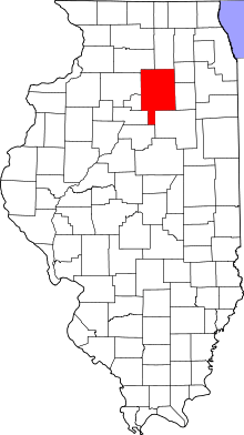 Location in the U.S. state of Illinois | |
 Illinois's location in the U.S. | |
| Founded | January 15, 1831 |
| Named for | René-Robert Cavelier, Sieur de La Salle |
| Seat | Ottawa |
| Largest city | Ottawa |
| Area | |
| • Total | 1,148 sq mi (2,973 km2) |
| • Land | 1,135 sq mi (2,940 km2) |
| • Water | 13 sq mi (34 km2), 1.1% |
| Population (est.) | |
| • (2015) | 111,333 |
| • Density | 98/sq mi (38/km2) |
| Congressional district | 16th |
| Time zone | Central: UTC−6/−5 |
| Website |
www |
LaSalle County is located in the North Central region of the U.S. state of Illinois; it has an estimated population of 111,241 as of 2014 and its county seat and largest city is Ottawa.[3]
LaSalle County is part of the Ottawa-Peru, IL Micropolitan Statistical Area, which is also included in the Chicago-Naperville, IL-IN-WI Combined Statistical Area.
LaSalle County borders Woodford, Marshall, Putnam, Bureau, Livingston, Lee, DeKalb, Kendall, and Grundy counties. Though LaSalle County is in the Chicago media market, it retains a unique identity with a mix of pleasant river towns, and vast expanses of farmland. The county is at the intersection of the Chicago, Peoria, Quad Cities and Rockford television markets, with all four regions advertising (and businesses from the respective regions) and having a strong influence on the area such that despite the county's short distance from Chicago, approximately 60 miles (97 km). The county is part of the far southwestern reaches of the Chicago metropolitan area, and it is also part of the Fox Valley subregion and the larger Northern Illinois region.
History
LaSalle County was formed on January 15, 1831 out of Tazewell and Putnam Counties. It is named for the early French explorer René-Robert Cavelier, Sieur de La Salle.[4] La Salle was the first European recorded as entering the area. He traveled the Mississippi River upriver from the Gulf of Mexico, claimed the land for France, or rather as a possession of King Louis XIV of France and named it Louisiana. In 1680, he and two other French traders built Fort Crevecoeur on the Illinois River in present-day Tazewell County, and in 1662, the Fort St. Louis on Starved Rock in present-day LaSalle County. By 1857, the county was served by the daily arrivals of two trains of the Illinois Central Railroad.
As William D. Boyce reportedly founded the Boy Scouts of America in Ottawa, the Council is named for him. He and two other founders established the BSA, but Boyce is given the sole credit since his faction of the BSA adopted the other two competing factions' elements within the organization. LaSalle County is within what is called the Lowaneu Region of the W.D. Boyce Council.
The Tri-County Area of DeKalb, LaSalle, and Kendall Counties have been influential in terms of their political, sports, multimedia, industry, and technology. DeKalb County was the birthplace of plant hybridization (DeKalb, DeKalb Agricultural), the hot-air hand dryer (Sandwich, Sahara-Pak), and is the home of supermodel Cindy Crawford, at least 6 MLB players, two NFL coaches, and three NFL players. LaSalle County was home to the Westclox Company for many years, was the site of the first Lincoln-Douglas Debates, and was the home to the discoverer of Pluto, as well as a Wild West figure, multiple published authors, a legendary NCAA athletic director and coach, and multiple political figures. Kendall County is the home to a seminal piece of 20th Century architecture, the birthplace of the Harvester Reaper, (as well as the precursor to the International Harvester Company), the plastic tackle box and plastic-injection molding, and is the home of multiple athletes, politicians, and a former Speaker of the House of Representatives. DeKalb, LaSalle, and Kendall Counties have all been featured in major films, either having been written by residents or former residents, having been filmed in the communities, or both.
La Salle County was founded largely by immigrants from New England. These were old stock Yankee immigrants, who were descended from the English Puritans who settled New England in the 1600s. The completion of the Erie Canal caused a surge in New England immigration to what was then the Northwest Territory. The end of the Black Hawk War led to an additional surge of immigration, once again coming almost exclusively from the six New England states as a result of overpopulation combined with land shortages in that region. Some of these later settlers were from upstate New York and had parents who had moved to that region from New England shortly after the Revolutionary War. New Englanders and New England transplants from upstate New York were the vast majority of La Salle County's inhabitants during the first several decades of its history. These settlers were primarily members of the Congregational Church, though due to the Second Great Awakening, many of them had converted to Methodism, and some had become Baptists before coming to what is now La Salle County. The Congregational Church has subsequently gone through many divisions, and some factions, including those in La Salle County, are now known as the Church of Christ and the United Church of Christ. As a result of this heritage, the vast majority of inhabitants in La Salle County − much like antebellum New England − were overwhelmingly in favor of the abolitionist movement during the decades leading up to the Civil War.[5] When the New Englanders arrived in what is now La Salle County, there was nothing but dense virgin forest and wild prairie. They laid out farms, constructed roads, erected government buildings and established post routes. In 1834, Norwegian immigrants settled in the northwest corner of the county. In the late 1880s and early 1890s Irish and German migrants began moving into La Salle County; most of these later immigrants did not move directly from Ireland and Germany, but rather from other areas in the Midwest where they had been living, particularly the state of Ohio.[6] Immigrants around the Peterstown, Troy Grove, Meriden, Mendota, and Earlville area were largely of German descent, with the Mendota area directly being the epicenter of the German community in the county. Norwegian population has been strong in the area around Northville, Serena, Mission, and Miller Townships in LaSalle County, along with Little Rock and Fox Townships in Kendall County, and Sandwich and Somonauk Townships in DeKalb County. One such family, the Borschsenius family, runs the Norway Store in the unincorporated community of Norway, in southern Mission Township, and the family has been deeply involved with businesses and the school district of nearby Serena and Sheridan.
Ottawa was the first site of the famous Lincoln–Douglas debates on August 21, 1858. The community has a strong association with the 16th President, and elements of the downtown area of the city retain much mid-19th century architecture. People in LaSalle County were predominantly abolitionist in attitude, and many Underground Railroad sites were maintained in the county prior to the American Civil War.
Utica (or the official name of North Utica) is considered the gateway to the Starved Rock area. Visiting three parks provides a full experience of the area. Starved Rock State Park, (south of Utica on Illinois Route 178), is the crown jewel. Matthiessen State Park (south of Starved Rock on Ill 178) has many of the same features of Starved Rock, but is smaller, and faces the Vermilion River to the west. Buffalo Rock State Park (east of Utica, and west of Naplate/Ottawa on Dee Bennett Road) has an enclosure which features American bison, as well as the mound sculpture complex, known as the Effigy Tumuli. The village is most well known for the April 20, 2004 tornado, which ripped through the downtown and killed nine people.
 LaSalle County from the time of its creation to 1836, including a large tract of unorganized territory temporarily attached to it.[7]
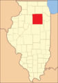 LaSalle County between 1836 and 1837
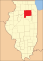 LaSalle County between 1837 and 1841
 LaSalle County between 1841 and 1843
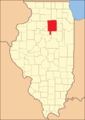 In 1843, the southwest corner was ceded to Marshall County, reducing LaSalle to its present size
Geography
According to the U.S. Census Bureau, the county has a total area of 1,148 square miles (2,970 km2), of which 1,135 square miles (2,940 km2) is land and 13 square miles (34 km2) (1.1%) is water.[8] It is the second-largest county in Illinois by land area and the fourth-largest by total area.
Adjacent counties
- Lee County- northwest
- DeKalb County - north
- Kendall County - northeast
- Grundy County - east
- Livingston County - southeast
- Woodford County - south
- Marshall County - southwest
- Putnam County - west
- Bureau County - west
LaSalle County, Illinois, is one of the few counties in the United States to border as many as nine counties. Illinois has two such counties, with Pike County being the other.
Many of the residents of LaSalle County live in cities and towns along the Illinois River. It is the main population core, with some exceptions, including Streator to the south of the county. Large cities along the river include Ottawa, LaSalle, Peru, and Marseilles. The regions north and south of the Illinois River are mostly agricultural, including the Fox River portion of the county, and have few large towns.
Climate
| Ottawa, Illinois | ||||||||||||||||||||||||||||||||||||||||||||||||||||||||||||
|---|---|---|---|---|---|---|---|---|---|---|---|---|---|---|---|---|---|---|---|---|---|---|---|---|---|---|---|---|---|---|---|---|---|---|---|---|---|---|---|---|---|---|---|---|---|---|---|---|---|---|---|---|---|---|---|---|---|---|---|---|
| Climate chart (explanation) | ||||||||||||||||||||||||||||||||||||||||||||||||||||||||||||
| ||||||||||||||||||||||||||||||||||||||||||||||||||||||||||||
| ||||||||||||||||||||||||||||||||||||||||||||||||||||||||||||
In recent years, average temperatures in the county seat of Ottawa have ranged from a low of 12 °F (−11 °C) in January to a high of 85 °F (29 °C) in July, although a record low of −25 °F (−32 °C) was recorded in January 1985 and a record high of 112 °F (44 °C) was recorded in July 1936. Average monthly precipitation ranged from 1.32 inches (34 mm) in February to 4.13 inches (105 mm) in June.[9]
Demographics
| Historical population | |||
|---|---|---|---|
| Census | Pop. | %± | |
| 1840 | 9,348 | — | |
| 1850 | 17,815 | 90.6% | |
| 1860 | 48,332 | 171.3% | |
| 1870 | 60,792 | 25.8% | |
| 1880 | 70,403 | 15.8% | |
| 1890 | 80,798 | 14.8% | |
| 1900 | 87,776 | 8.6% | |
| 1910 | 90,132 | 2.7% | |
| 1920 | 92,925 | 3.1% | |
| 1930 | 97,695 | 5.1% | |
| 1940 | 97,801 | 0.1% | |
| 1950 | 100,610 | 2.9% | |
| 1960 | 110,800 | 10.1% | |
| 1970 | 111,409 | 0.5% | |
| 1980 | 112,003 | 0.5% | |
| 1990 | 106,913 | −4.5% | |
| 2000 | 111,509 | 4.3% | |
| 2010 | 113,924 | 2.2% | |
| Est. 2016 | 110,642 | [10] | −2.9% |
| U.S. Decennial Census[11] 2012 Estimate[12] | |||
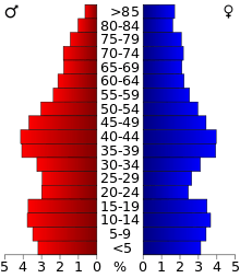
As of the 2010 United States Census, there were 113,924 people, 45,347 households, and 30,116 families residing in the county.[13] The population density was 100.4 inhabitants per square mile (38.8/km2). There were 49,978 housing units at an average density of 44.0 per square mile (17.0/km2).[8] The racial makeup of the county was 93.2% white, 1.9% black or African American, 0.7% Asian, 0.3% American Indian, 2.5% from other races, and 1.4% from two or more races. Those of Hispanic or Latino origin made up 8.0% of the population.[13] In terms of ancestry, 33.7% were German, 19.0% were Irish, 9.8% were English, 9.2% were Italian, 7.8% were Polish, 6.0% were American, and 5.5% were Norwegian.[14]
Of the 45,347 households, 30.3% had children under the age of 18 living with them, 50.9% were married couples living together, 10.5% had a female householder with no husband present, 33.6% were non-families, and 28.6% of all households were made up of individuals. The average household size was 2.45 and the average family size was 3.00. The median age was 41.0 years.[13]
The median income for a household in the county was $51,705 and the median income for a family was $62,252. Males had a median income of $49,551 versus $30,207 for females. The per capita income for the county was $24,982. About 8.0% of families and 10.8% of the population were below the poverty line, including 15.3% of those under age 18 and 6.8% of those age 65 or over.[15]
Education
School districts
Secondary schools
Public
- Earlville High School (CUSD 9), also has district area in DeKalb and Lee Counties
- LaSalle-Peru High School, LaSalle
- Leland High School, Leland, also has district area in DeKalb County
- Mendota Township High School, Mendota, also has district area in Bureau and Lee Counties
- Newark Community High School, located within Kendall County, but serves Mission Township
- Ottawa Township High School, Ottawa
- Sandwich Community High School (CUSD 430), located within DeKalb County, but serves Northville Township
- Seneca High School, also has district area in Grundy County
- Serena High School (CUSD 2)
- Somonauk High School, located within DeKalb County, but serves Northville and Adams Townships
- Streator Township High School, Streator
- Woodland High School, Streator
Private
- Marquette High School, Ottawa
- St. Bede Academy, Peru
- , Ottawa Christian Academy, Ottawa
Colleges and universities
- Illinois Valley Community College, Oglesby and Ottawa
Infrastructure
Transportation
Airports
- Earlville Airport, closed in 2010
- Illinois Valley Regional Airport, Peru
Major highways
Utilities
Communities
Cities
Villages
- Cedar Point
- Dalzell (part)
- Dana
- Grand Ridge
- Kangley
- Leland
- Leonore
- Lostant
- Millington (part)
- Naplate
- North Utica
- Ransom
- Rutland
- Seneca (part)
- Sheridan
- Somonauk (part)
- Tonica
- Troy Grove
Census-designated places
Other unincorporated communities
Townships
LaSalle County is divided into thirty-seven townships:
- Adams
- Allen
- Brookfield
- Bruce
- Dayton
- Deer Park
- Dimmick
- Eagle
- Earl
- Eden
- Fall River
- Farm Ridge
- Freedom
- Grand Rapids
- Groveland
- Hope
- LaSalle
- Manlius
- Mendota
- Meriden
- Miller
- Mission
- Northville
- Ophir
- Osage
- Ottawa
- Otter Creek
- Peru
- Richland
- Rutland
- Serena
- South Ottawa
- Troy Grove
- Utica
- Vermillion
- Wallace
- Waltham
Ghost towns
Politics
| Elected countywide officials | |||||||
|---|---|---|---|---|---|---|---|
| Auditor | Jody Wilkinson | Democratic | |||||
| County Board Chairman | Jerry Hicks | Democratic | |||||
| County Board Majority | 18-11[16] | Republican | |||||
| Circuit Clerk | Greg Vacarro | Republican | |||||
| County Clerk | Jo Ann Carretto | Democratic | |||||
| Coroner | William Wujek | Democratic | |||||
| Recorder | Karen Friestad Miller | Republican | |||||
| Sheriff | Tom Templeton | Republican | |||||
| State’s Attorney | Karen Donnelly | Republican | |||||
| Regional Superintendent | Chris Dvorak | Democratic | |||||
LaSalle has generally been a Republican-leaning swing county, more competitive than most in urbanized Northern Illinois.
In its early years LaSalle County supported the Democratic Party, being southwest of the Free Soil strongholds in the far northeast of the state. Following the formation of the Republican party, LaSalle County voted for that party in every election until 1884, when it supported Democrat Grover Cleveland three consecutive times. Although the county gave a plurality to Woodrow Wilson in 1912 and supported Franklin D. Roosevelt in his first three elections, it otherwise voted Republican until 1960.
A Democratic trend, typical of Yankee Northern Illinois, saw Michael Dukakis carry LaSalle despite failing to win the election in 1988, and no Republican would carry the county again until George Bush junior in 2004. The past few elections have seen the county lean Republican due to concern over lack of employment opportunities in the "Rust Belt".
| Year | Republican | Democratic | Third Parties |
|---|---|---|---|
| 2016 | 53.7% 26,689 | 39.3% 19,543 | 7.1% 3,511 |
| 2012 | 49.1% 23,256 | 48.7% 23,073 | 2.3% 1,076 |
| 2008 | 43.5% 21,872 | 54.6% 27,443 | 2.0% 995 |
| 2004 | 51.5% 26,101 | 47.8% 24,263 | 0.7% 365 |
| 2000 | 46.3% 21,276 | 50.8% 23,355 | 3.0% 1,376 |
| 1996 | 36.0% 15,299 | 50.9% 21,643 | 13.1% 5,549 |
| 1992 | 32.2% 16,078 | 46.6% 23,276 | 21.2% 10,577 |
| 1988 | 49.6% 22,166 | 49.9% 22,271 | 0.5% 213 |
| 1984 | 56.9% 27,388 | 42.7% 20,532 | 0.5% 219 |
| 1980 | 57.1% 27,323 | 35.2% 16,818 | 7.7% 3,694 |
| 1976 | 51.4% 25,114 | 47.3% 23,105 | 1.3% 646 |
| 1972 | 59.2% 31,190 | 40.6% 21,405 | 0.2% 92 |
| 1968 | 50.5% 26,054 | 44.5% 22,940 | 5.1% 2,616 |
| 1964 | 40.7% 21,216 | 59.3% 30,923 | |
| 1960 | 50.0% 27,552 | 49.9% 27,532 | 0.1% 41 |
| 1956 | 64.5% 33,461 | 35.3% 18,318 | 0.2% 83 |
| 1952 | 60.5% 32,857 | 39.3% 21,321 | 0.2% 99 |
| 1948 | 55.0% 24,453 | 44.3% 19,666 | 0.7% 321 |
| 1944 | 54.3% 28,179 | 41.4% 21,489 | 4.3% 2,210 |
| 1940 | 45.7% 25,296 | 53.6% 29,704 | 0.7% 399 |
| 1936 | 43.4% 22,240 | 52.6% 26,926 | 4.0% 2,035 |
| 1932 | 40.3% 19,179 | 57.8% 27,500 | 1.9% 908 |
| 1928 | 53.2% 24,039 | 46.0% 20,807 | 0.8% 382 |
| 1924 | 60.5% 21,417 | 17.6% 6,216 | 22.0% 7,784 |
| 1920 | 73.2% 23,751 | 20.4% 6,626 | 6.4% 2,057 |
| 1916 | 56.6% 20,662 | 40.1% 14,625 | 3.3% 1,203 |
| 1912 | 24.6% 4,858 | 35.6% 7,036 | 39.9% 7,890[lower-alpha 1] |
| 1908 | 55.6% 11,159 | 37.8% 7,589 | 6.6% 1,326 |
| 1904 | 62.7% 11,967 | 29.5% 5,628 | 7.9% 1,500 |
| 1900 | 56.2% 11,781 | 41.4% 8,671 | 2.4% 504 |
| 1896 | 57.6% 11,548 | 40.4% 8,108 | 2.0% 391 |
| 1892 | 44.1% 7,957 | 51.9% 9,365 | 3.9% 711 |
Visitor attractions
- Hegeler Carus Mansion
- Hopalong Cassidy River Trail
- Illini State Park
- Kaskaskia Alliance Trail
- LaSalle Lake State Fish and Wildlife Area
- Middle East Conflicts Wall Memorial
- Ottawa Avenue Cemetery
- Plum Island Eagle Sanctuary
- Washington Park Historic District (Ottawa, Illinois)
- Wild Bill Hickok Memorial
Notable people
- James T. Aubrey (LaSalle) longtime president of CBS Television network
- Bill Brown, (Mendota) former running back for the Minnesota Vikings
- Herbert "Fritz" Crisler, (Earlville, Mendota) head football coach at the University of Michigan (1938–1947), namesake of the school's basketball stadium, and is credited for created the helmet design for the Michigan football team
- Doug Dieken, (rural Streator) former tackle with the Cleveland Browns (1971-1984); color commentary for Browns radio broadcasts
- Walter T. Gunn, Illinois Supreme Court justice, born in LaSalle County
- J.A. Happ, (Peru) pitcher for Toronto Blue Jays; pitched for 2008 World Series champion Philadelphia Phillies
- Wild Bill Hickok, (Troy Grove) noted historical Western Figure
- Helen Hokinson, (Mendota) cartoonist for The New Yorker
- Silas Johnson, (Sheridan) credited as the last pitcher to strike out Herman "Babe" Ruth; played for the Cincinnati Reds
- Harry Kelly, (Ottawa) 39th governor of Michigan
- Terrence Malick, (Ottawa) film director, known for Badlands and The Thin Red Line; born in Ottawa
- Bob McGrath, (Ottawa), Sesame Street performer
- Clarence E. Mulford, (Streator) wrote the "Hopalong Cassidy" cowboy novels
- Cleng Peerson, established the community of Norway
- Edward H. Plumb, (Streator) film composer, worked with Walt Disney on Fantasia; nominated four times for an Academy Award
- Maud Powell, (Peru) violinist
- Thomas E. G. Ransom, Civil War general, lived in Peru, namesake of Ransom
- Adam Shabala, (Streator) former outfielder for the San Francisco Giants
- Aaron Shea, (Ottawa) player for the Cleveland Browns
- Clyde Tombaugh, (Streator) astronomer, discovered Pluto
- Martin R. M. Wallace, (Ottawa) Civil War general
- W.H.L. Wallace, (Ottawa) Civil War general
- Walt Willey, (Ottawa) actor, known for All My Children
- Gary K. Wolf, (Earlville) author of Who Censored Roger Rabbit?, adopted into the movie Who Framed Roger Rabbit
- Clay Zavada, (Streator) pitcher for the Arizona Diamondbacks
See also
Notes
- ↑ There were only 6,918 votes for the leading "other" candidate, Progressive Theodore Roosevelt, plus 636 for Socialist Eugene V. Debs, 286 for the Prohibition Party's Eugene Chafin, and 50 for Socialist Labor candidate Arthur Reimer.
References
- Specific
- ↑ "La Salle County, Illinois - Fact Sheet". American FactFinder. United States Census Bureau. 2000. Archived from the original on 6 June 2011. Retrieved 26 February 2010.
- ↑ U.S. Geological Survey Geographic Names Information System: LaSalle County
- ↑ "Find a County". National Association of Counties. Archived from the original on 2011-05-31. Retrieved 2011-06-07.
- ↑ Gannett, Henry (1905). The Origin of Certain Place Names in the United States. U.S. Government Printing Office. p. 182.
- ↑ History of La Salle County, Illinois: Together with Sketches of Its Cities, Villages and Towns, Educational, Religious, Civil, Military, and Political History, Portraits of Prominent Persons, and Biographies of Representative Citizens : Also a Condensed History of Illinois, Embodying Accounts of Prehistoric Races, Aborigines, Winnebago and Black Hawk Wars, and a Brief Review of Its Civil and Political History, Volume 1 by Inter-state Publishing Company, 1886
- ↑ History of LaSalle County, Illinois, Volume 1 by Michael Cyprian O'Byrne Higginson Book Company, 1924
- ↑ White, Jesse. Origin and Evolution of Illinois Counties. State of Illinois, March 2010. "Archived copy" (PDF). Archived (PDF) from the original on 2012-09-30. Retrieved 2012-09-26.
- 1 2 "Population, Housing Units, Area, and Density: 2010 - County". United States Census Bureau. Retrieved 2015-07-12.
- 1 2 "Monthly Averages for Ottawa, Illinois". The Weather Channel. Archived from the original on 2010-09-15. Retrieved 2011-01-27.
- ↑ "Population and Housing Unit Estimates". Archived from the original on May 29, 2017. Retrieved June 9, 2017.
- ↑ "U.S. Decennial Census". Census.gov. Archived from the original on May 12, 2015. Retrieved July 27, 2013.
- ↑ "Annual Estimates of the Resident Population: April 1, 2010 to July 1, 2012". Census.gov. Archived from the original on July 7, 2013. Retrieved July 27, 2013.
- 1 2 3 "DP-1 Profile of General Population and Housing Characteristics: 2010 Demographic Profile Data". United States Census Bureau. Retrieved 2015-07-12.
- ↑ "DP02 SELECTED SOCIAL CHARACTERISTICS IN THE UNITED STATES – 2006-2010 American Community Survey 5-Year Estimates". United States Census Bureau. Retrieved 2015-07-12.
- ↑ "DP03 SELECTED ECONOMIC CHARACTERISTICS – 2006-2010 American Community Survey 5-Year Estimates". United States Census Bureau. Retrieved 2015-07-12.
- ↑ "LaSalle County board". lasallecounty.org. Archived from the original on 2016-12-01.
- ↑ Leip, David. "Dave Leip's Atlas of U.S. Presidential Elections". uselectionatlas.org. Archived from the original on 2018-03-23.
- General
- Forstall, Richard L. (editor) (1996). Population of states and counties of the United States: 1790 to 1990 : from the twenty-one decennial censuses. United States Department of Commerce, Bureau of the Census, Population Division. ISBN 0-934213-48-8.
External links
| Wikimedia Commons has media related to LaSalle County, Illinois. |
Places adjacent to LaSalle County, Illinois | ||||||||||
|---|---|---|---|---|---|---|---|---|---|---|
| ||||||||||
Municipalities and communities of LaSalle County, Illinois, United States | ||
|---|---|---|
| Cities | ||
| Villages | ||
| Townships |
| |
| CDPs | ||
| Other unincorporated communities |
| |
| Ghost towns |
| |
| Footnotes | ‡This populated place also has portions in an adjacent county or counties | |
| Major city |  | |
|---|---|---|
| Cities (over 30,000 in 2010) | ||
| Towns and villages (over 30,000 in 2010) |
| |
| Counties | ||
| Regions | ||
| Sub-regions | ||
