List of counties in Mississippi
| Counties of Mississippi | |
|---|---|
| Location | State of Mississippi |
| Number | 82 |
| Populations |
Greatest: 245,285 (Hinds) Least: 4,836 (Issaquena) Average: 36,448 (2016) |
| Areas |
Largest: 920 square miles (2,400 km2) (Yazoo) Smallest: 400 square miles (1,000 km2) (Alcorn) Average: 591 square miles (1,530 km2) |
| Government | County government |
| Subdivisions | cities, towns, unincorporated communities, census designated place |
There are 82 counties in the U.S. state of Mississippi.
Mississippi's postal abbreviation is MS and its FIPS state code is 28.
Smithsonian Trinomial county designations in Mississippi. Counties; AD-Adams, AL-Alcorn, AM-Amite, AT-Attala, BE-Benton, BO-Bolivar, CN-Calhoun, CA-Carroll, CS-Chickasaw, CH-Choctaw, CB-Claiborne, CK-Clarke, CL-Clay, CO-Coahoma, CP-Copiah, CV-Covington, DS-DeSoto, FO-Forrest, FR-Franklin, GE-George, GN-Greene, GR-Grenada, HA-Hancock, HR-Harrison, HI-Hinds, HO-Holmes, HU-Humphreys, IS-Issaquena, IT-Itawamba, JA-Jackson, JS-Jasper, JE-Jefferson, JD-Jefferson Davis, JO-Jones, KE-Kemper, LA-Lafayette, LM-Lamar, LD-Lauderdale, LW-Lawrence LK-Leake, LE-Lee, LF-Leflore, LI-Lincoln, LO-Lowndes, MD-Madison, MA-Marion, MR-Marshall, MO-Monroe, MT-Montgomery, NE-Neshoba, NW-Newton, NO-Noxubee, OK-Oktibbeha, PA-Panola, PR-Pearl River, PE-Perry, PI-Pike, PO-Pontotoc, PS-Prentiss, QU-Quitman, RA-Rankin, SC-Scott, SH-Sharkey, SI-Simpson, SM-Smith, ST-Stone, SU-Sunflower, TL-Tallahatchie, TA-Tate, TI-Tippah, TS-Tishomingo, TU-Tunica, UN-Union, WL-Walthall, WR-Warren, WS-Washington, WA-Wayne, WE-Webster, WK-Wilkinson, WI-Winston, YA-Yalobusha, YZ-Yazoo. [1]
List
| County |
FIPS code[2] | County seat[3] | Established[4] | Origin | Etymology | Population[3] | Area[4] | Map |
|---|---|---|---|---|---|---|---|---|
| Adams County | 001 | Natchez | 1799 | One of two original counties | John Adams, second U.S. President | 32,297 | 460 sq mi (1,191 km2) | 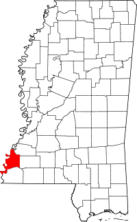 |
| Alcorn County | 003 | Corinth | 1870 | Formed from Tippiah and Tishomingo Counties | James L. Alcorn, Reconstruction-era U.S. Senator from Mississippi | 37,057 | 400 sq mi (1,036 km2) | 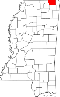 |
| Amite County | 005 | Liberty | 1809 | Formed from Wilkinson County | Amite River | 13,131 | 730 sq mi (1,891 km2) | 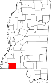 |
| Attala County | 007 | Kosciusko | 1833 | Formed from Madison County | A fictional Native American heroine from an early 19th-century novel by François-René de Chateaubriand. | 19,564 | 735 sq mi (1,904 km2) | 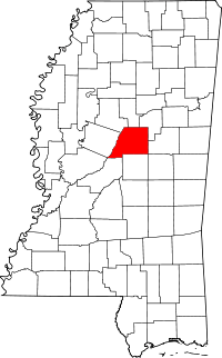 |
| Benton County | 009 | Ashland | 1870 | Formed from Marshall and Tippah Counties | Thomas Hart Benton, U.S. Senator from Missouri and prominent westward expansion advocate | 8,729 | 407 sq mi (1,054 km2) |  |
| Bolivar County | 011 | Cleveland and Rosedale | 1836 | Formed from Tallahatchie and Washington Counties | Simon Bolivar, South American democratic revolutionary | 34,145 | 876 sq mi (2,269 km2) | 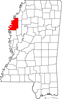 |
| Calhoun County | 013 | Pittsboro | 1852 | Formed from Chickasaw, Lafayette and Yalobusha Counties | John C. Calhoun, U.S. Senator from South Carolina and prominent supporter of states' rights | 14,962 | 587 sq mi (1,520 km2) |  |
| Carroll County | 015 | Carrollton and Vaiden | 1833 | Formed from Lowndes, Monroe, Washington and Yazoo Counties | Charles Carroll, last surviving signer of the Declaration of Independence | 10,597 | 628 sq mi (1,627 km2) | 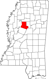 |
| Chickasaw County | 017 | Houston and Okolona | 1836 | Formed from Monroe County and Un-Organized | Chickasaw Native Americans | 17,392 | 502 sq mi (1,300 km2) |  |
| Choctaw County | 019 | Ackerman | 1833 | Formed from Lowndes, Madison, Monroe and Yazoo Counties | Choctaw Native Americans | 8,547 | 419 sq mi (1,085 km2) |  |
| Claiborne County | 021 | Port Gibson | 1802 | Formed from Jefferson (Pickering) County | William C. C. Claiborne, Governor of the Mississippi Territory | 9,604 | 487 sq mi (1,261 km2) | 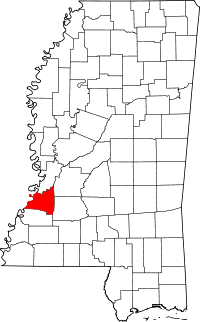 |
| Clarke County | 023 | Quitman | 1833 | Formed from Wayne County | Joshua G. Clark, the first elected judge following admittance to the Union | 16,732 | 691 sq mi (1,790 km2) | 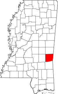 |
| Clay County | 025 | West Point | 1871 | Formed from Chickasaw, Lowndes, Monroe and Oktibbeha Counties (formerly (Colfax County) | Henry Clay, U.S. Senator from Kentucky and giant of 19th century politics | 20,634 | 409 sq mi (1,059 km2) | 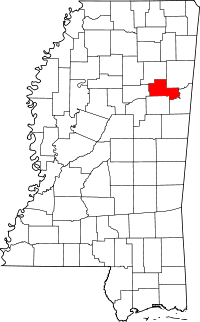 |
| Coahoma County | 027 | Clarksdale | 1836 | Formed from Un-Organized | derives from Native American word meaning "red panther" | 26,151 | 554 sq mi (1,435 km2) | 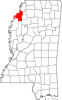 |
| Copiah County | 029 | Hazlehurst | 1823 | Formed from Franklin and Hinds Counties | derives from Native American word meaning "calling panther" | 29,449 | 777 sq mi (2,012 km2) | 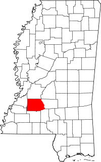 |
| Covington County | 031 | Collins | 1819 | Formed from Lawrence and Wayne Counties | Leonard Covington, War of 1812 general | 19,568 | 414 sq mi (1,072 km2) | 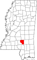 |
| DeSoto County | 033 | Hernando | 1836 | Formed from Monroe and Washington Counties | Hernando de Soto, Spanish explorer of the Americas | 161,252 | 478 sq mi (1,238 km2) |  |
| Forrest County | 035 | Hattiesburg | 1906 | Formed from Perry County | Nathan B. Forrest, Confederate general | 74,934 | 467 sq mi (1,210 km2) | 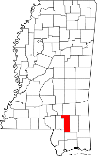 |
| Franklin County | 037 | Meadville | 1809 | Formed from Adams County | Benjamin Franklin, writer, orator, publisher, and U.S. founding father | 8,118 | 565 sq mi (1,463 km2) | 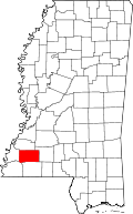 |
| George County | 039 | Lucedale | 1910 | Formed from Greene and Jackson Counties | James Z. George, U.S. Senator from Mississippi | 22,578 | 478 sq mi (1,238 km2) | 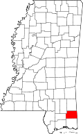 |
| Greene County | 041 | Leakesville | 1811 | Formed from Wayne County | Nathanael Greene, American Revolutionary War general | 14,400 | 713 sq mi (1,847 km2) | 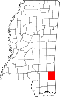 |
| Grenada County | 043 | Grenada | 1870 | Formed from Carroll, Choctaw, Tallahatchie and Yalobusha Counties | Spanish province of Granada (spelling variation) | 21,906 | 422 sq mi (1,093 km2) | 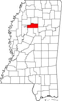 |
| Hancock County | 045 | Bay Saint Louis | 1812 | Formed from Un-Organized | John Hancock, first signer of the Declaration of Independence | 43,929 | 477 sq mi (1,235 km2) | 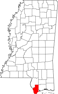 |
| Harrison County | 047 | Gulfport and Biloxi | 1841 | Formed from Hancock County | William Henry Harrison, ninth U.S. President | 187,105 | 581 sq mi (1,505 km2) | 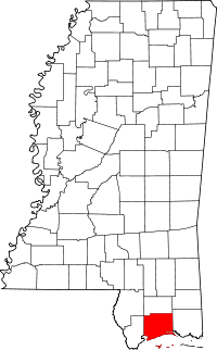 |
| Hinds County | 049 | Jackson and Raymond | 1821 | Formed from Un-Organized (Choctaw Cession of 1820) | Thomas Hinds, War of 1812 general | 245,285 | 869 sq mi (2,251 km2) | 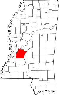 |
| Holmes County | 051 | Lexington | 1833 | Formed from Yazoo County | David Holmes, first Governor of Mississippi | 19,198 | 756 sq mi (1,958 km2) | 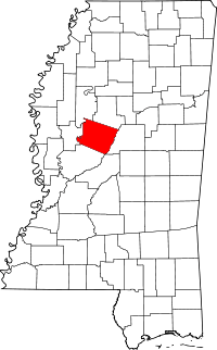 |
| Humphreys County | 053 | Belzoni | 1918 | Formed from Holmes, Sunflower, Washington and Yazoo Counties | Benjamin G. Humphreys, Reconstruction-era Governor of Mississippi | 9,375 | 418 sq mi (1,083 km2) | 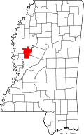 |
| Issaquena County | 055 | Mayersville | 1844 | Formed from Washington County | Native American word for "Deer River" | 1,406 | 413 sq mi (1,070 km2) | 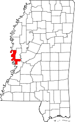 |
| Itawamba County | 057 | Fulton | 1836 | Formed from Monroe County | Itawamba, Chickasaw chief | 23,401 | 532 sq mi (1,378 km2) | 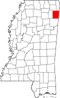 |
| Jackson County | 059 | Pascagoula | 1812 | Formed from Un-Organized | Andrew Jackson, War of 1812 hero and seventh U.S. President | 139,668 | 727 sq mi (1,883 km2) | 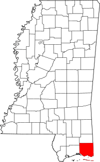 |
| Jasper County | 061 | Bay Springs and Paulding | 1833 | Formed from Jones and Wayne Counties | William Jasper, Revolutionary War sergeant | 17,062 | 676 sq mi (1,751 km2) | 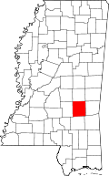 |
| Jefferson County | 063 | Fayette | 1799 | One of two original Counties (formerly Pickering) | Thomas Jefferson, third U.S. President and principal author of the Declaration of Independence | 7,726 | 519 sq mi (1,344 km2) | 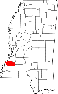 |
| Jefferson Davis County | 065 | Prentiss | 1906 | Formed from Covington and Lawrence Counties | Jefferson Davis, C.S. President | 12,487 | 408 sq mi (1,057 km2) | 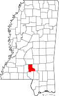 |
| Jones County | 067 | Laurel and Ellisville | 1826 | Formed from Covington and Wayne Counties (formerly Davis (1865-1869 (Civil War)) | John Paul Jones, Revolutionary War naval captain | 67,761 | 694 sq mi (1,797 km2) | 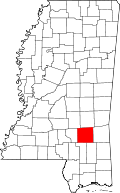 |
| Kemper County | 069 | De Kalb | 1833 | Formed from Lowndes, Rankin and Wayne Counties | Reuben Kemper, American pioneer and revolutionary in Spanish Florida | 10,456 | 766 sq mi (1,984 km2) | 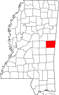 |
| Lafayette County | 071 | Oxford | 1836 | Formed from Monroe County | Marquis de la Fayette, French-born Revolutionary War general | 47,351 | 631 sq mi (1,634 km2) | 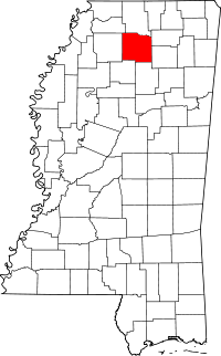 |
| Lamar County | 073 | Purvis | 1904 | Formed from Marion and Pearl River Counties | Lucius Q. C. Lamar, U.S. Senator from Mississippi and United States Secretary of the Interior | 55,658 | 497 sq mi (1,287 km2) | 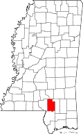 |
| Lauderdale County | 075 | Meridian | 1833 | Formed from Rankin and Wayne Counties | James Lauderdale, War of 1812 colonel | 80,261 | 704 sq mi (1,823 km2) | 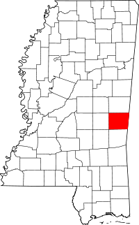 |
| Lawrence County | 077 | Monticello | 1814 | Formed from Marion County | James Lawrence, War of 1812 naval captain | 12,929 | 431 sq mi (1,116 km2) | 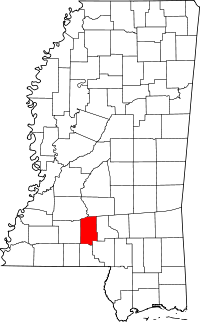 |
| Leake County | 079 | Carthage | 1833 | Formed from Madison and Rankin Counties | Walter Leake, Governor of Mississippi | 23,805 | 583 sq mi (1,510 km2) | 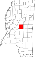 |
| Lee County | 081 | Tupelo | 1866 | Formed from Itawamba and Pontotoc Counties | Robert E. Lee, General in Chief of the Armies of the Confederate States | 82,910 | 450 sq mi (1,165 km2) |  |
| Leflore County | 083 | Greenwood | 1871 | Formed from Carroll and Sunflower Counties | Greenwood LeFlore, mixed-race advocate of citizenship for Native Americans and U.S. Senator from Mississippi | 32,317 | 592 sq mi (1,533 km2) |  |
| Lincoln County | 085 | Brookhaven | 1870 | Formed from Amite, Copiah, Franklin, Lawrence and Pike Counties | Abraham Lincoln, sixteenth U.S. President | 34,869 | 586 sq mi (1,518 km2) |  |
| Lowndes County | 087 | Columbus | 1830 | Formed from Monroe County and Un-Organized | William Jones Lowndes, U.S. Representative from South Carolina | 59,779 | 502 sq mi (1,300 km2) |  |
| Madison County | 089 | Canton | 1828 | Formed from Yazoo County | James Madison, fourth U.S. President | 95,203 | 719 sq mi (1,862 km2) | 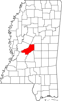 |
| Marion County | 091 | Columbia | 1811 | Formed from Amite, Franklin and Wayne Counties | Francis Marion, Revolutionary War general | 27,088 | 542 sq mi (1,404 km2) | 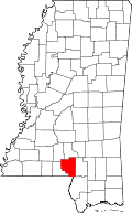 |
| Marshall County | 093 | Holly Springs | 1836 | Formed from Monroe County | John Marshall, Chief Justice of the United States who shaped the Supreme Court's power | 37,144 | 706 sq mi (1,829 km2) | 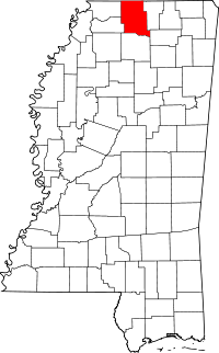 |
| Monroe County | 095 | Aberdeen | 1821 | Formed from Un-Organized (Chickasaw Cession of 1816) | James Monroe, fifth U.S. President | 36,989 | 764 sq mi (1,979 km2) | 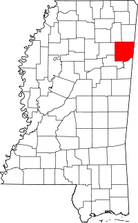 |
| Montgomery County | 097 | Winona | 1871 | Formed from Carroll and Choctaw Counties | Richard Montgomery, Revolutionary War general | 10,925 | 407 sq mi (1,054 km2) | 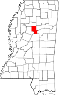 |
| Neshoba County | 099 | Philadelphia | 1833 | Formed from Jones, Madison, Rankin and Wayne Counties | Native American word for "gray wolf" | 29,676 | 570 sq mi (1,476 km2) | 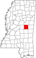 |
| Newton County | 101 | Decatur | 1836 | Formed from Neshoba County | Isaac Newton, English scientist | 21,720 | 578 sq mi (1,497 km2) | 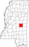 |
| Noxubee County | 103 | Macon | 1833 | Formed from Lowndes and Rankin Counties | Native American for "stinking water" | 11,545 | 695 sq mi (1,800 km2) | 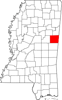 |
| Oktibbeha County | 105 | Starkville | 1833 | Formed from Lowndes County | Native American word for "bloody water" | 47,671 | 458 sq mi (1,186 km2) | 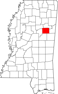 |
| Panola County | 107 | Batesville and Sardis | 1836 | Formed from Monroe and Washington Counties | Native American for "cotton" | 34,707 | 684 sq mi (1,772 km2) | 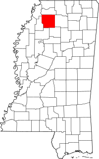 |
| Pearl River County | 109 | Poplarville | 1890 | Formed from Hancock and Marion Counties | Pearl River | 55,834 | 812 sq mi (2,103 km2) | 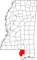 |
| Perry County | 111 | New Augusta | 1820 | Formed from Greene County | Oliver Hazard Perry, War of 1812 naval captain | 12,250 | 647 sq mi (1,676 km2) | 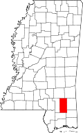 |
| Pike County | 113 | Magnolia | 1815 | Formed from Marion County | Zebulon Pike, western explorer | 40,404 | 409 sq mi (1,059 km2) | 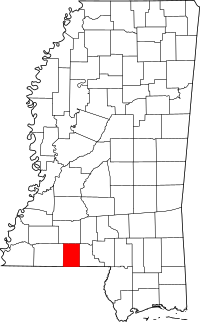 |
| Pontotoc County | 115 | Pontotoc | 1836 | Formed from Monroe County | Native American for "land of hanging grapes" | 29,957 | 497 sq mi (1,287 km2) | 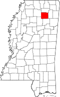 |
| Prentiss County | 117 | Booneville | 1870 | Formed from Itawamba and Tishomingo Counties | Seargent Smith Prentiss, U.S. Representative from Mississippi | 25,276 | 415 sq mi (1,075 km2) | 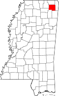 |
| Quitman County | 119 | Marks | 1877 | Formed from Coahoma, Panola, Tallahatchie and Tunica Counties | John A. Quitman, Governor of Mississippi | 8,223 | 405 sq mi (1,049 km2) | 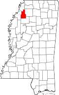 |
| Rankin County | 121 | Brandon | 1828 | Formed from Hinds County | Christopher Rankin, U.S. Representative from Mississippi | 141,617 | 775 sq mi (2,007 km2) | 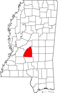 |
| Scott County | 123 | Forest | 1833 | Formed from Covington, Jones and Rankin Counties | Abram M. Scott, Governor of Mississippi | 28,264 | 609 sq mi (1,577 km2) | 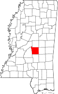 |
| Sharkey County | 125 | Rolling Fork | 1876 | Formed from Issaquena, Warren and Washington Counties | William L. Sharkey, Mississippi Supreme Court justice | 4,916 | 428 sq mi (1,109 km2) | 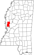 |
| Simpson County | 127 | Mendenhall | 1824 | Formed from Copiah County | Josiah Simpson, first federal judge appointed in the state | 27,503 | 589 sq mi (1,526 km2) | 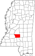 |
| Smith County | 129 | Raleigh | 1833 | Formed from Covington, Jones and Rankin Counties | David Smith, Revolutionary War major | 16,491 | 636 sq mi (1,647 km2) | 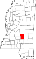 |
| Stone County | 131 | Wiggins | 1916 | Formed from Harrison County | John M. Stone, Governor of Mississippi | 17,786 | 445 sq mi (1,153 km2) | 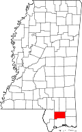 |
| Sunflower County | 133 | Indianola | 1844 | Formed from Bolivar County | Sunflower River | 29,450 | 694 sq mi (1,797 km2) | 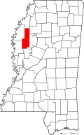 |
| Tallahatchie County | 135 | Charleston and Sumner | 1833 | Formed from Washington and Yazoo Counties | Tallahatchie River | 15,378 | 644 sq mi (1,668 km2) | 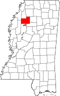 |
| Tate County | 137 | Senatobia | 1873 | Formed from DeSoto and Marshall Counties | Thomas Simpson Tate, the county's original settler | 28,886 | 404 sq mi (1,046 km2) | 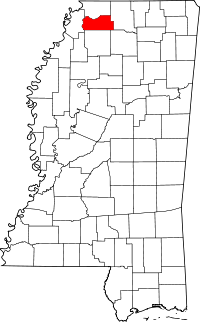 |
| Tippah County | 139 | Ripley | 1836 | Formed from Monroe County | Native American word for "cut off" | 22,232 | 458 sq mi (1,186 km2) | 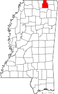 |
| Tishomingo County | 141 | Iuka | 1836 | Formed from Monroe County | Chief Tishomingo, Chickasaw leader | 19,593 | 424 sq mi (1,098 km2) | 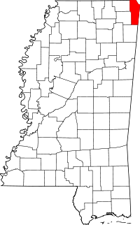 |
| Tunica County | 143 | Tunica | 1836 | Formed from Washington County and Un-Organized | Tunica Native Americans | 10,778 | 455 sq mi (1,178 km2) | 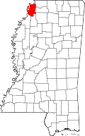 |
| Union County | 145 | New Albany | 1870 | Formed from Lee, Pontotoc and Tippah Counties | Reunion of Confederacy with the United States | 27,134 | 416 sq mi (1,077 km2) | 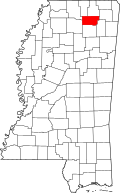 |
| Walthall County | 147 | Tylertown | 1912 | Formed from Marion and Pike Counties | Edward Walthall, U.S. Senator from Mississippi | 15,443 | 404 sq mi (1,046 km2) | 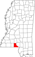 |
| Warren County | 149 | Vicksburg | 1809 | Formed from Claiborne County | Joseph Warren, Revolutionary War general | 48,773 | 587 sq mi (1,520 km2) | 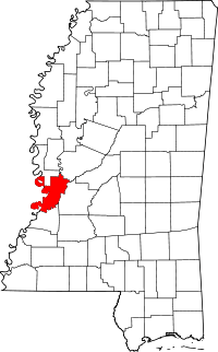 |
| Washington County | 151 | Greenville | 1827 | Formed from Warren and Yazoo Counties | George Washington, first U.S. President | 51,137 | 724 sq mi (1,875 km2) | 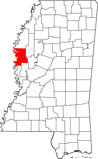 |
| Wayne County | 153 | Waynesboro | 1809 | Formed from Washington County (AL) | Anthony Wayne, Revolutionary War general | 20,747 | 810 sq mi (2,098 km2) | 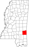 |
| Webster County | 155 | Walthall | 1874 | Formed from Chickasaw, Choctaw and Montegomery Counties (formerly Sumner County) | Daniel Webster, U.S. Senator from Massachusetts and giant of Nineteenth Century politics | 10,253 | 423 sq mi (1,096 km2) | 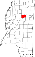 |
| Wilkinson County | 157 | Woodville | 1802 | Formed from Adams County | James Wilkinson, Revolutionary War general | 9,878 | 677 sq mi (1,753 km2) | 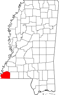 |
| Winston County | 159 | Louisville | 1833 | Formed from Lowndes, Rankin, and Wayne Counties | Louis Winston, Mississippi Supreme Court justice | 19,198 | 607 sq mi (1,572 km2) | 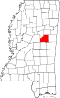 |
| Yalobusha County | 161 | Water Valley and Coffeeville | 1833 | Formed from Monroe, Washington and Yazoo Counties | Native American for "tadpole place" | 12,678 | 467 sq mi (1,210 km2) | 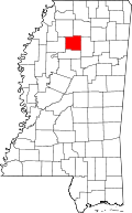 |
| Yazoo County | 163 | Yazoo City | 1823 | Formed from Hinds County | Yazoo Native Americans | 28,065 | 920 sq mi (2,383 km2) | 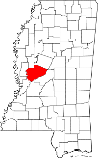 |
References
- ↑ Mississippi Department of Archives and History.
- ↑ "EPA County FIPS Code Listing". EPA.gov. Retrieved 2008-02-23.
- 1 2 Bureau of the Census, USA. "GeoHive - USA, Mississippi state population statistics". Retrieved 7 April 2011.
- 1 2 National Association of Counties. "NACo - Find a county". Retrieved 2008-04-30.
.svg.png)