List of counties in Kansas
| Counties of Kansas | |
|---|---|
 | |
| Location | State of Kansas |
| Number | 105 |
| Populations | 1,298 (Greeley) – 559,913 (Johnson) |
| Areas | 151 square miles (390 km2) (Wyandotte) – 1,428 square miles (3,700 km2) (Butler) |
| Government | County government |
| Subdivisions | cities, towns, townships, unincorporated communities, indian reservations, census designated place |
This is a list of counties in the U.S. state of Kansas. Select from the links at right to go directly to an article, or browse the listing below for additional information. Every license plate issued by the state contains the same two-letter abbreviation for the county in which its vehicle is registered.
Kansas has 105 counties, the sixth-highest total of any state. Many of the counties in the eastern part of the state are named after prominent Americans from the late 18th and early-to-mid-19th centuries, while those in the central and western part of the state are named for figures in the American Civil War. Several counties throughout the state bear names of Native American origin. No Kansas county has two words in its name.
Wyandotte County and the city of Kansas City operate as a unified government. As of January 1, 2009 Greeley County and the city of Tribune unified to form the Unified Government of Greeley County.[1]
Alphabetical list
| County |
FIPS code[2] | County seat[3] | Established[3] | Origin | Etymology[4] | County Code |
Population[5] | Area[3] | Map |
|---|---|---|---|---|---|---|---|---|---|
| Allen County | 001 | Iola | 1855 | One of the original 36 counties | William Allen, U.S. Senator from Ohio and prominent supporter of westward expansion | AL | 13,319 | 503 sq mi (1,303 km2) | 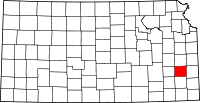 |
| Anderson County | 003 | Garnett | 1855 | One of the original 36 counties | Joseph C. Anderson, Kansas territorial legislator and Border Ruffian during "Bleeding Kansas" | AN | 7,917 | 583 sq mi (1,510 km2) | 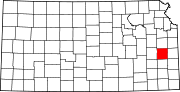 |
| Atchison County | 005 | Atchison | 1855 | One of the original 36 counties | David Rice Atchison, U.S. Senator from Missouri and Border Ruffian during "Bleeding Kansas" | AT | 16,813 | 432 sq mi (1,119 km2) | 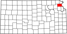 |
| Barber County | 007 | Medicine Lodge | 1867 | From unorganized area | Thomas W. Barber, prominent Free-Stater killed in the Wakarusa War | BA | 4,861 | 1,134 sq mi (2,937 km2) | 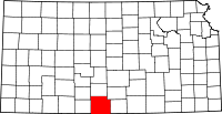 |
| Barton County | 009 | Great Bend | 1867 | From unorganized area | Clara Barton, founder of the American Red Cross | BT | 27,557 | 894 sq mi (2,315 km2) | 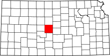 |
| Bourbon County | 011 | Fort Scott | 1855 | One of the original 36 counties | Bourbon County, Kentucky, from which many original settlers hailed | BB | 14,897 | 637 sq mi (1,650 km2) | 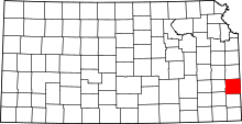 |
| Brown County | 013 | Hiawatha | 1855 | One of the original 36 counties (Formerly Browne County) | Albert Gallatin Brown, U.S. Senator from Mississippi and Kansas statehood advocate | BR | 9,881 | 571 sq mi (1,479 km2) | 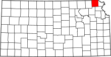 |
| Butler County | 015 | El Dorado | 1855 | One of the original 36 counties | Andrew Pickens Butler, U.S. Senator from South Carolina and Kansas statehood advocate | BU | 65,827 | 1,428 sq mi (3,699 km2) | 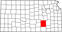 |
| Chase County | 017 | Cottonwood Falls | 1859 | Formed from Butler and Wise counties | Salmon Portland Chase, U.S. Senator from Ohio and Kansas statehood advocate | CS | 2,757 | 776 sq mi (2,010 km2) | 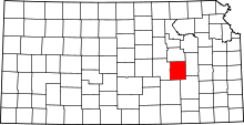 |
| Chautauqua County | 019 | Sedan | 1875 | Formed from Howard County | Chautauqua County, New York, from which many early settlers hailed | CQ | 3,571 | 642 sq mi (1,663 km2) | 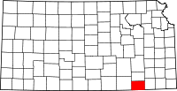 |
| Cherokee County | 021 | Columbus | 1855 | One of the original 36 counties (Formerly McGee County) | Cherokee Native Americans, whose lands borders the county in nearby Indian Territory | CK | 21,226 | 587 sq mi (1,520 km2) |  |
| Cheyenne County | 023 | Saint Francis | 1873 | From unorganized area | Cheyenne Native Americans, who inhabited the area | CN | 2,678 | 1,020 sq mi (2,642 km2) |  |
| Clark County | 025 | Ashland | 1885 | Formed from Ford County | Charles F. Clarke, Captain in 6th Regiment Kansas Volunteer Cavalry during American Civil War[6] | CA | 2,181 | 975 sq mi (2,525 km2) | 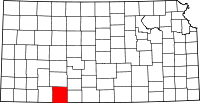 |
| Clay County | 027 | Clay Center | 1857 | From unorganized area | Henry Clay, influential U.S. Senator from Kentucky | CY | 8,531 | 644 sq mi (1,668 km2) | 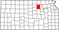 |
| Cloud County | 029 | Concordia | 1866 | Formed from Washington (Formerly Shirley County) | William F. Cloud, Union general in the American Civil War who chiefly fought in Kansas and Missouri | CD | 9,397 | 716 sq mi (1,854 km2) | 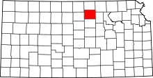 |
| Coffey County | 031 | Burlington | 1855 | One of the original 36 counties | A.M. Coffey, territorial legislator and Free-Stater during Bleeding Kansas | CF | 8,502 | 630 sq mi (1,632 km2) | 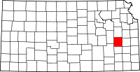 |
| Comanche County | 033 | Coldwater | 1867 | From unorganized area | Comanche Native Americans, who lived in the area | CM | 1,913 | 788 sq mi (2,041 km2) | 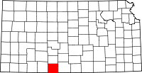 |
| Cowley County | 035 | Winfield | 1867 | Formed from Butler County | Matthew R. Cowley, Union lieutenant and distinguished Civil War hero | CL | 36,288 | 1,126 sq mi (2,916 km2) |  |
| Crawford County | 037 | Girard | 1867 | Bourbon and Cherokee Counties | Samuel J. Crawford, third Governor of Kansas | CR | 39,361 | 593 sq mi (1,536 km2) | 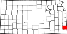 |
| Decatur County | 039 | Oberlin | 1873 | From unorganized area | Stephen Decatur, naval commodore and War of 1812 hero | DC | 2,871 | 894 sq mi (2,315 km2) | 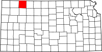 |
| Dickinson County | 041 | Abilene | 1857 | From unorganized area | Daniel Stevens Dickinson, U.S. Senator from New York and Kansas statehood advocate | DK | 19,762 | 848 sq mi (2,196 km2) | 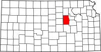 |
| Doniphan County | 043 | Troy | 1855 | One of the original 36 counties | Alexander William Doniphan, Mexican–American War hero and pro-slavery sympathizer in "Bleeding Kansas" | DP | 7,864 | 392 sq mi (1,015 km2) | 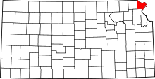 |
| Douglas County | 045 | Lawrence | 1855 | One of the original 36 counties | Stephen Arnold Douglas, U.S. Senator from Illinois and advocate for the moderate popular sovereignty choice in the Kansas slavery debate | DG | 112,864 | 457 sq mi (1,184 km2) |  |
| Edwards County | 047 | Kinsley | 1874 | Formed from Kiowa County | John H. Edwards, state senator who pushed for creation of the county | ED | 2,979 | 622 sq mi (1,611 km2) | 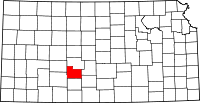 |
| Elk County | 049 | Howard | 1875 | Formed from Howard County | Elk River, which originates in the county | EK | 2,720 | 648 sq mi (1,678 km2) | 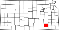 |
| Ellis County | 051 | Hays | 1867 | From unorganized area | George Ellis, Union lieutenant and distinguished Civil War hero | EL | 29,053 | 900 sq mi (2,331 km2) | 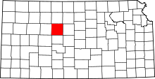 |
| Ellsworth County | 053 | Ellsworth | 1867 | From unorganized area | Fort Ellsworth, a Union Civil War outpost in the area | EW | 6,494 | 716 sq mi (1,854 km2) | 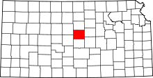 |
| Finney County | 055 | Garden City | 1883 | Formed from Arapahoe, Grant, Kearney and Sequoyah Counties | David W. Finney, tenth lieutenant governor of Kansas | FI | 37,200 | 1,300 sq mi (3,367 km2) | 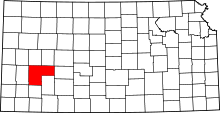 |
| Ford County | 057 | Dodge City | 1867 | From unorganized area | James H. Ford, Union general in the Civil War who mainly fought in Kansas and Missouri | FO | 34,752 | 1,099 sq mi (2,846 km2) | 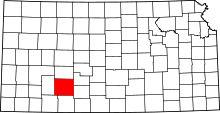 |
| Franklin County | 059 | Ottawa | 1855 | One of the original 36 counties | Benjamin Franklin, orator, writer, scholar, and founding father of the U.S. | FR | 25,906 | 574 sq mi (1,487 km2) | 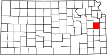 |
| Geary County | 061 | Junction City | 1855 | One of the original 36 counties (Formerly Davis County) | John White Geary, Union general in the Civil War who mainly fought in Kansas and Missouri, and who later became Kansas territorial governor | GE | 38,013 | 384 sq mi (995 km2) | 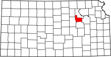 |
| Gove County | 063 | Gove City | 1868 | From unorganized area | Grenville L. Gove, Captain in the 11th Regiment Kansas Volunteer Cavalry during the Civil War[7] | GO | 2,729 | 1,072 sq mi (2,776 km2) | 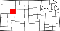 |
| Graham County | 065 | Hill City | 1867 | From unorganized area | John L. Graham, Union captain and Civil War hero | GH | 2,578 | 898 sq mi (2,326 km2) | 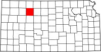 |
| Grant County | 067 | Ulysses | 1888 | Formed from Finney and Hamilton Counties | Ulysses Simpson Grant, commander of Union forces during the Civil War and U.S. President | GT | 7,923 | 575 sq mi (1,489 km2) | 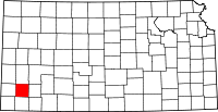 |
| Gray County | 069 | Cimarron | 1887 | Formed from Finney and Ford Counties | Alfred Gray, Kansas Secretary of Agriculture | GY | 6,030 | 869 sq mi (2,251 km2) | 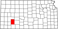 |
| Greeley County | 071 | Tribune | 1873 | From unorganized area | Horace Greeley, publisher of the New York Tribune and anti-slavery advocate | GL | 1,298 | 778 sq mi (2,015 km2) | 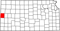 |
| Greenwood County | 073 | Eureka | 1855 | One of the original 36 counties | Alfred B. Greenwood, U.S. Representative from Arkansas and Kansas statehood advocate | GW | 6,454 | 1,140 sq mi (2,953 km2) | 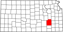 |
| Hamilton County | 075 | Syracuse | 1873 | From unorganized area | Alexander Hamilton, first U.S. Treasury Secretary and founding father | HM | 2,639 | 996 sq mi (2,580 km2) | 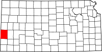 |
| Harper County | 077 | Anthony | 1867 | From unorganized area | Marion Harper, Union sergeant and Civil War hero | HP | 5,911 | 802 sq mi (2,077 km2) | 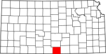 |
| Harvey County | 079 | Newton | 1872 | Formed from McPherson, Sedgwick and Reno Counties | James M. Harvey, fifth governor of Kansas | HV | 34,852 | 539 sq mi (1,396 km2) | 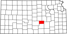 |
| Haskell County | 081 | Sublette | 1887 | Formed from Finney and Ford Counties | Dudley Chase Haskell, U.S. Representative from Kansas | HS | 4,256 | 577 sq mi (1,494 km2) | 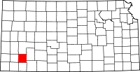 |
| Hodgeman County | 083 | Jetmore | 1867 | From unorganized area (Formerly Hageman County) | Amos Hodgman, Union captain and Civil War hero | HG | 1,963 | 860 sq mi (2,227 km2) | 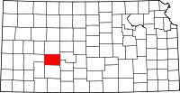 |
| Jackson County | 085 | Holton | 1855 | One of the original 36 counties (Formerly Calhoun County) | Andrew Jackson, seventh U.S. President | JA | 13,449 | 657 sq mi (1,702 km2) | 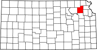 |
| Jefferson County | 087 | Oskaloosa | 1855 | One of the original 36 counties | Thomas Jefferson, third U.S. President and founding father | JF | 18,945 | 536 sq mi (1,388 km2) | 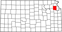 |
| Jewell County | 089 | Mankato | 1867 | From unorganized area | Lewis R. Jewell, Union colonel and Civil War hero | JW | 3,046 | 909 sq mi (2,354 km2) | 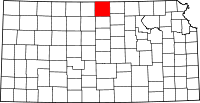 |
| Johnson County | 091 | Olathe | 1855 | One of the original 36 counties | Thomas Johnson, Methodist missionary who was one of the state's first settlers | JO | 559,913 | 477 sq mi (1,235 km2) | 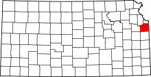 |
| Kearny County | 093 | Lakin | 1887 | Formed from Finney and Hamilton Counties | Philip Kearny, American general in the Mexican–American and Civil Wars | KE | 3,968 | 870 sq mi (2,253 km2) | 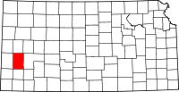 |
| Kingman County | 095 | Kingman | 1872 | Harper and Reno Counties | Samuel A. Kingman, Chief Justice of the Kansas Supreme Court | KM | 7,863 | 864 sq mi (2,238 km2) | 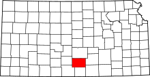 |
| Kiowa County | 097 | Greensburg | 1886 | Formed from Comanche and Edwards Counties | Kiowa Native Americans, who inhabited the area | KW | 2,496 | 722 sq mi (1,870 km2) | 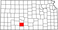 |
| Labette County | 099 | Oswego | 1867 | Formed from Neosho County | Pierre La Bette, French fur trapper who formed a peaceful relationship with area natives | LB | 21,284 | 649 sq mi (1,681 km2) | 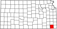 |
| Lane County | 101 | Dighton | 1873 | From unorganized area | James H. Lane, U.S. Senator from Kansas and Free-Stater during "Bleeding Kansas" | LE | 1,704 | 717 sq mi (1,857 km2) | 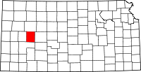 |
| Leavenworth County | 103 | Leavenworth | 1855 | One of the original 36 counties | Henry Leavenworth, general in the Indian Wars who established a fort in the area | LV | 77,739 | 463 sq mi (1,199 km2) | 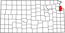 |
| Lincoln County | 105 | Lincoln | 1867 | From unorganized area | Abraham Lincoln, sixteenth U.S. President | LC | 3,174 | 719 sq mi (1,862 km2) | 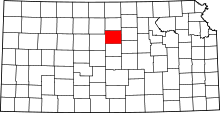 |
| Linn County | 107 | Mound City | 1855 | One of the original 36 counties | Lewis Fields Linn, U.S. Senator from Kentucky whose family was later involved in the settlement of Kansas | LN | 9,441 | 599 sq mi (1,551 km2) | 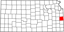 |
| Logan County | 109 | Oakley | 1888 | Formed from Wallace County (formerly named St. John County) | John Alexander Logan, prominent Union Civil War general and U.S. Senator from Illinois | LG | 2,784 | 1,073 sq mi (2,779 km2) | 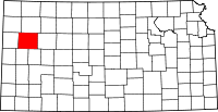 |
| Lyon County | 111 | Emporia | 1855 | One of the original 36 counties (Formerly Breckenridge County) | Nathaniel Lyon, first Union general to be killed in the Civil War | LY | 33,748 | 851 sq mi (2,204 km2) | 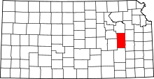 |
| Marion County | 115 | Marion | 1860 | From unorganized area | Francis Marion, American Revolutionary War hero | MN | 12,347 | 943 sq mi (2,442 km2) | 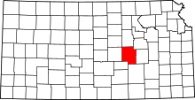 |
| Marshall County | 117 | Marysville | 1855 | One of the original 36 counties | Frank J. Marshall, state representative who became locally known for operating the first ferry over the Big Blue River | MS | 10,022 | 903 sq mi (2,339 km2) | 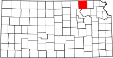 |
| McPherson County | 113 | McPherson | 1867 | From unorganized area | James Birdseye McPherson, prominent Union Civil War general | MP | 29,356 | 900 sq mi (2,331 km2) | 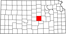 |
| Meade County | 119 | Meade | 1885 | Formed from Finney, Ford and Seward Counties | George Gordon Meade, Union Civil War general best known for his victory at the Battle of Gettysburg | ME | 4,396 | 978 sq mi (2,533 km2) | 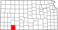 |
| Miami County | 121 | Paola | 1855 | One of the original 36 counties (Formerly Lykins) | Miami Native Americans, who lived in the area | MI | 32,612 | 577 sq mi (1,494 km2) | 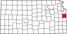 |
| Mitchell County | 123 | Beloit | 1867 | From unorganized area | William D. Mitchell, Union captain and Civil War hero | MC | 6,355 | 700 sq mi (1,813 km2) | 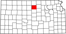 |
| Montgomery County | 125 | Independence | 1867 | Formed from Wilson County | Richard Montgomery, Revolutionary War hero | MG | 34,459 | 645 sq mi (1,671 km2) | 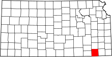 |
| Morris County | 127 | Council Grove | 1855 | One of the original 36 counties (Formerly Wise County) | Thomas Morris, U.S. Senator from Ohio and anti-slavery advocate | MR | 5,854 | 697 sq mi (1,805 km2) | 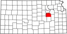 |
| Morton County | 129 | Elkhart | 1886 | Formed from Seward County | Oliver P. Morton, Governor of Indiana and prominent anti-slavery advocate | MT | 3,169 | 730 sq mi (1,891 km2) | 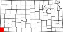 |
| Nemaha County | 131 | Seneca | 1855 | One of the original 36 counties (Formerly Dorn County) | Nemaha River, which passes through the county | NM | 10,132 | 719 sq mi (1,862 km2) | 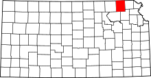 |
| Neosho County | 133 | Erie | 1855 | One of the original 36 counties (Formerly Dorn County) | Neosho River, which passes through the county | NO | 16,406 | 572 sq mi (1,481 km2) | 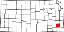 |
| Ness County | 135 | Ness City | 1867 | From unorganized area | Noah V. Ness, Corporal in 7th Regiment Kansas Volunteer Cavalry during Civil War[8] | NS | 3,068 | 1,075 sq mi (2,784 km2) | 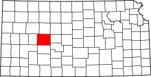 |
| Norton County | 137 | Norton | 1867 | From unorganized area (Formerly Billings (1873-9) | Orloff Norton, Union captain and Civil War hero | NT | 5,612 | 878 sq mi (2,274 km2) | 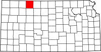 |
| Osage County | 139 | Lyndon | 1855 | One of the original 36 counties (Formerly Weller County) | Osage River, which flows through the county | OS | 16,142 | 704 sq mi (1,823 km2) | 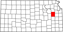 |
| Osborne County | 141 | Osborne | 1867 | From unorganized area | Vincent B. Osborne, Union soldier and Civil War hero | OB | 3,806 | 893 sq mi (2,313 km2) |  |
| Ottawa County | 143 | Minneapolis | 1860 | From unorganized area | Ottawa Native Americans, who lived in the area | OT | 6,072 | 721 sq mi (1,867 km2) |  |
| Pawnee County | 145 | Larned | 1867 | From unorganized area | Pawnee Native Americans, who lived in the area | PN | 6,928 | 754 sq mi (1,953 km2) |  |
| Phillips County | 147 | Phillipsburg | 1867 | From unorganized area | William Phillips, state legislator who pushed for creation of the county, and later U.S. Representative | PL | 5,519 | 886 sq mi (2,295 km2) |  |
| Pottawatomie County | 149 | Westmoreland | 1857 | Formed from Calhoun and Riley | Pottawatomie Native Americans, who lived in the area | PT | 22,302 | 844 sq mi (2,186 km2) | 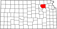 |
| Pratt County | 151 | Pratt | 1867 | From unorganized area | Caleb Pratt, Union lieutenant and Civil War hero | PR | 9,728 | 735 sq mi (1,904 km2) | 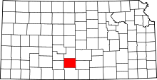 |
| Rawlins County | 153 | Atwood | 1873 | From unorganized area | John Aaron Rawlins, prominent Union Civil War general | RA | 2,560 | 1,070 sq mi (2,771 km2) | 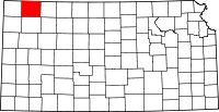 |
| Reno County | 155 | Hutchinson | 1867 | From unorganized area | Jesse L. Reno, prominent Union Civil War general | RN | 64,438 | 1,254 sq mi (3,248 km2) | 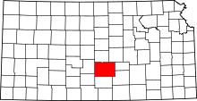 |
| Republic County | 157 | Belleville | 1868 | Formed from Washington County | Republican River, which flows through the county | RP | 4,858 | 716 sq mi (1,854 km2) | 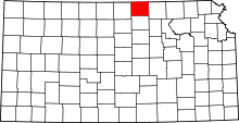 |
| Rice County | 159 | Lyons | 1867 | From unorganized area | Samuel A. Rice, prominent Union Civil War general | RC | 9,985 | 727 sq mi (1,883 km2) | 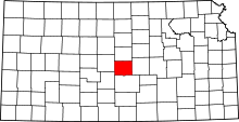 |
| Riley County | 161 | Manhattan | 1855 | One of the original 36 counties | Bennett C. Riley, Mexican–American War hero | RL | 75,508 | 610 sq mi (1,580 km2) | 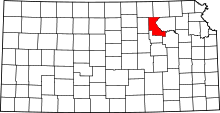 |
| Rooks County | 163 | Stockton | 1867 | From unorganized area | John C. Rooks, Private in 11th Regiment Kansas Volunteer Cavalry during Civil War[6] | RO | 5,223 | 888 sq mi (2,300 km2) | 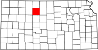 |
| Rush County | 165 | La Crosse | 1867 | From unorganized area | Alexander Rush, Union captain and Civil War hero | RH | 3,220 | 718 sq mi (1,860 km2) | 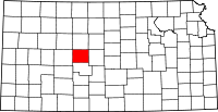 |
| Russell County | 167 | Russell | 1867 | From unorganized area | Avra P. Russell, Union captain and Civil War hero | RS | 6,946 | 885 sq mi (2,292 km2) | 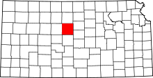 |
| Saline County | 169 | Salina | 1860 | From unorganized area | Saline River, which flows through the county | SA | 55,988 | 720 sq mi (1,865 km2) | 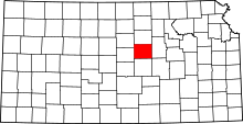 |
| Scott County | 171 | Scott City | 1873 | From unorganized area | Winfield Scott, Mexican–American War hero and unsuccessful presidential candidate | SC | 4,937 | 718 sq mi (1,860 km2) | 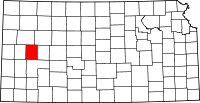 |
| Sedgwick County | 173 | Wichita | 1867 | Formed from Butler County | John Sedgwick, highest ranking Union general killed in the Civil War | SG | 503,889 | 1,000 sq mi (2,590 km2) | 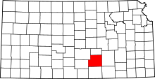 |
| Seward County | 175 | Liberal | 1873 | From unorganized area | William Henry Seward, U.S. Secretary of State | SW | 23,547 | 640 sq mi (1,658 km2) | 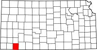 |
| Shawnee County | 177 | Topeka | 1855 | One of the original 36 counties | Shawnee Native Americans, who lived in the area | SN | 178,991 | 550 sq mi (1,424 km2) | 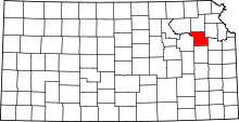 |
| Sheridan County | 179 | Hoxie | 1873 | From unorganized area | Philip Henry Sheridan, prominent Union Civil War general | SD | 2,538 | 896 sq mi (2,321 km2) | 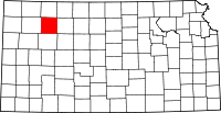 |
| Sherman County | 181 | Goodland | 1873 | From unorganized area | William Tecumseh Sherman, prominent Civil War general | SH | 6,113 | 1,056 sq mi (2,735 km2) | 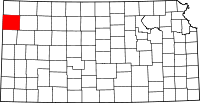 |
| Smith County | 183 | Smith Center | 1867 | From unorganized area | J. Nelson Smith, Union major and Civil War hero | SM | 3,765 | 896 sq mi (2,321 km2) | 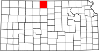 |
| Stafford County | 185 | Saint John | 1867 | From unorganized area | Lewis Stafford, Union captain and Civil War hero | SF | 4,358 | 792 sq mi (2,051 km2) | 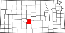 |
| Stanton County | 187 | Johnson City | 1887 | Formed from Hamilton County | Edwin McMasters Stanton, U.S. Secretary of War during the Civil War | ST | 2,175 | 680 sq mi (1,761 km2) | 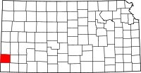 |
| Stevens County | 189 | Hugoton | 1886 | Formed from Seward County | Thaddeus Stevens, U.S. Representative from Pennsylvania who was a leader of Reconstruction politics | SV | 5,756 | 728 sq mi (1,886 km2) | 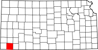 |
| Sumner County | 191 | Wellington | 1867 | Formed from Butler County | Charles Sumner, U.S. Senator from Massachusetts who was a leader of Reconstruction politics | SU | 23,674 | 1,182 sq mi (3,061 km2) | 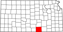 |
| Thomas County | 193 | Colby | 1873 | From unorganized area | George Henry Thomas, prominent Union Civil War general | TH | 7,941 | 1,075 sq mi (2,784 km2) | 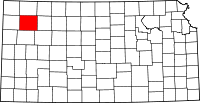 |
| Trego County | 195 | WaKeeney | 1867 | From unorganized area | Edgar P. Trego, Union captain and Civil War hero | TR | 2,986 | 888 sq mi (2,300 km2) | 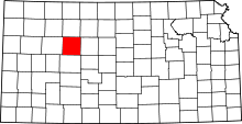 |
| Wabaunsee County | 197 | Alma | 1855 | One of the original 36 counties (Formerly Richardson County) | Chief Wabaunsee, Potawatomi leader | WB | 7,039 | 798 sq mi (2,067 km2) | 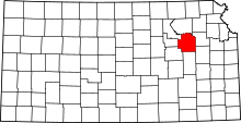 |
| Wallace County | 199 | Sharon Springs | 1868 | From unorganized area | W.H.L. Wallace, prominent Union Civil War general | WA | 1,517 | 914 sq mi (2,367 km2) | 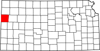 |
| Washington County | 201 | Washington | 1857 | From unorganized area | George Washington, first U.S. President and founding father | WS | 5,758 | 898 sq mi (2,326 km2) | 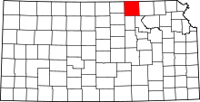 |
| Wichita County | 203 | Leoti | 1873 | From unorganized area | Wichita Native Americans, who lived in the area | WH | 2,256 | 719 sq mi (1,862 km2) | 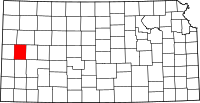 |
| Wilson County | 205 | Fredonia | 1855 | One of the original 36 counties | Hiero T. Wilson, Union colonel and Civil War hero | WL | 9,105 | 574 sq mi (1,487 km2) | 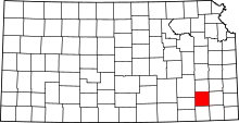 |
| Woodson County | 207 | Yates Center | 1855 | One of the original 36 counties | Daniel Woodson, five time acting governor of Kansas Territory | WO | 3,278 | 501 sq mi (1,298 km2) | 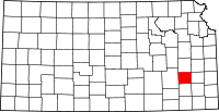 |
| Wyandotte County | 209 | Kansas City | 1859 | Formed from Leavenworth and Johnson Counties | Wyandotte Native Americans, who lived in the area | WY | 159,129 | 151 sq mi (391 km2) | 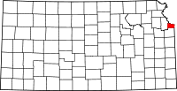 |
Former counties of Kansas
| County | Dates | Notes | Source |
|---|---|---|---|
| Washington | 1855–57 | One of 36 Original Counties. | [9] |
| Seward | 1861-67 | Formerly part of Godfroy. Dissolved into Greenwood and Howard Counties. | [10] |
| Godfrey | 1855-61 | One of the Original 36 Counties. Name changed to Seward around 1861. | [11] |
| Hunter | 1855-64 | One of the Original 36 Counties. Dissolved into Butler County. | [12] |
| Irving | 1860-64 | Formed from Hunter County. Dissolved into Butler County. | [13] |
| Otoe | 1860-64 | Formed from Unorganized Area and dissolved into Butler County. | [14] |
| Shirley | 1860-65 | Formed from Unorganized Area and dissolved into Washington County. | [15] |
| Peketon | 1860-65 | Formed from Unorganized Area and dissolved back into Unorganized Area. | [16] |
| Madison | 1855-61 | One of the Original 36 Counties. Dissolved into Breckenridge and Greenwood. | [17] |
| Howard | 1867-75 | Formed from Seward and Butler Counties. Dissolved into Chautauqua and Elk Counties. | [18] |
| Arapahoe | 1873-83 | Formed from Unorganized Area. Dissolved into Finney County. | [19] |
| Buffalo | 1873-81 | Formed from Unorganized Area. Dissolved into Gray County. | [20] |
| Kansas | 1873-83 | Formed from Unorganized Area. Dissolved into Seward County. | [21] |
| Sequoyah | 1873-83 | Formed from Unorganized Area. Dissolved into Finney County. | [22] |
| Garfield | 1887-93 | Formed from Finney and Hodgeman Counties and merged into Finney County. | [23] |
| Billings | 1873–74 | Created from Norton County and returned to Norton County. | [24] |
| Davis | ? | One of 36 Original Counties, now part of Geary County. | |
| Breckinridge | 1855-62 | Now Lyon County. | [25] |
See also
References
- ↑ "Unified Greely county". Unified Government of Greeley County. Retrieved 15 August 2013.
- ↑ "EPA County FIPS Code Listing". EPA.gov. Retrieved 2008-04-30.
- 1 2 3 National Association of Counties. "NACo - Find a county". Archived from the original on 25 October 2007. Retrieved 30 April 2008.
- ↑ Kansas State Historical Society (2009-12-17). "Kansas Counties". Kansas County Factsheets. Kansas State Historical Society. Retrieved 21 March 2010. Individual county pages are sources used.
- ↑ U.S. County 2012 Estimated Census; census.gov Archived 7 July 2013 at the Wayback Machine.
- 1 2 Kansas Place-Names, John Rydjord, University of Oklahoma Press, 1972, p. 400 ISBN 0-8061-0994-7
- ↑ Kansas Place-Names, John Rydjord, University of Oklahoma Press, 1972, p. 403 ISBN 0-8061-0994-7
- ↑ Kansas Place-Names, John Rydjord, University of Oklahoma Press, 1972, p. 407 ISBN 0-8061-0994-7
- ↑ Kansas State Historical Society. "Washington County, Kansas (old) (defunct)". Kansas County Factsheets. Kansas State Historical Society. Retrieved 27 November 2010.
- ↑ Kansas State Historical Society. "Seward County, Kansas (defunct)". Kansas County Factsheets. Kansas State Historical Society. Retrieved 27 November 2010.
- ↑ Kansas State Historical Society. "Godfrey County, Kansas (defunct)". Kansas County Factsheets. Kansas State Historical Society. Retrieved 3 April 2015.
- ↑ Kansas State Historical Society. "Hunter County, Kansas (defunct)". Kansas County Factsheets. Kansas State Historical Society. Retrieved 27 November 2010.
- ↑ Kansas State Historical Society. "Irving County, Kansas (defunct)". Kansas County Factsheets. Kansas State Historical Society. Retrieved 27 November 2010.
- ↑ Kansas State Historical Society. "Otoe County, Kansas (defunct)". Kansas County Factsheets. Kansas State Historical Society. Retrieved 27 November 2010.
- ↑ Kansas State Historical Society. "Shirley County, Kansas (defunct)". Kansas County Factsheets. Kansas State Historical Society. Retrieved 27 November 2010.
- ↑ Kansas State Historical Society. "Peketon County, Kansas (defunct)". Kansas County Factsheets. Kansas State Historical Society. Retrieved 27 November 2010.
- ↑ Kansas State Historical Society. "Madison County, Kansas (defunct)". Kansas County Factsheets. Kansas State Historical Society. Retrieved 27 November 2010.
- ↑ Kansas State Historical Society. "Howard County, Kansas (defunct)". Kansas County Factsheets. Kansas State Historical Society. Retrieved 27 November 2010.
- ↑ Kansas State Historical Society. "Arapahoe County, Kansas (2nd) (defunct)". Kansas County Factsheets. Kansas State Historical Society. Retrieved 27 November 2010.
- ↑ Kansas State Historical Society. "Buffalo County, Kansas (defunct)". Kansas County Factsheets. Kansas State Historical Society. Retrieved 27 November 2010.
- ↑ Kansas State Historical Society. "Kansas County, Kansas (defunct)". Kansas County Factsheets. Kansas State Historical Society. Retrieved 27 November 2010.
- ↑ Kansas State Historical Society. "Sequoyah County, Kansas (defunct)". Kansas County Factsheets. Kansas State Historical Society. Retrieved 27 November 2010.
- ↑ Kansas State Historical Society. "Garfield County, Kansas (defunct)". Kansas County Factsheets. Kansas State Historical Society. Retrieved 27 November 2010.
- ↑ Kansas State Historical Society. "Billings County, Kansas (defunct)". Kansas County Factsheets. Kansas State Historical Society. Retrieved 27 November 2010.
- ↑ Kansas State Historical Society. "Breckinridge County, Kansas (defunct)". Kansas County Factsheets. Kansas State Historical Society. Retrieved 14 August 2017.
External links
- The Establishment of Counties in Kansas—Maps and text transcribed from Transactions of the Kansas State Historical Society, 1903-1904.
