Adams County, Illinois
| Adams County, Illinois | |
|---|---|
 | |
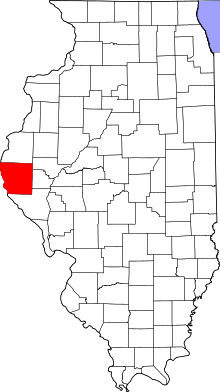 Location in the U.S. state of Illinois | |
 Illinois's location in the U.S. | |
| Founded | 1825 |
| Named for | John Quincy Adams |
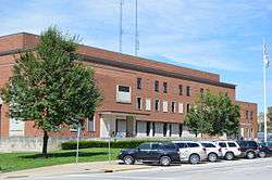
| Seat | Quincy |
| Largest city | Quincy |
| Area | |
| • Total | 871 sq mi (2,256 km2) |
| • Land | 855 sq mi (2,214 km2) |
| • Water | 16 sq mi (41 km2), 1.9% |
| Population (est.) | |
| • (2016) | 66,578[1] |
| • Density | 78/sq mi (30/km2) |
| Congressional district | 18th |
| Time zone | Central: UTC−6/−5 |
| Website |
www |
Adams County is the westernmost county of the U.S. state of Illinois. As of the 2010 census, the population was 67,103.[2] Its county seat is Quincy.[3]
Adams County is part of the Quincy, IL–MO Micropolitan Statistical Area.
History
Adams County was formed in 1825 out of Pike County. Its name is in honor of the sixth President of the United States, John Quincy Adams.
 When it was created, Hancock County was temporarily attached to Adams until it could organize a county government.[4]
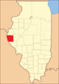 Adams County reduced to its current borders in 1829.
Geography
| Quincy, Illinois | ||||||||||||||||||||||||||||||||||||||||||||||||||||||||||||
|---|---|---|---|---|---|---|---|---|---|---|---|---|---|---|---|---|---|---|---|---|---|---|---|---|---|---|---|---|---|---|---|---|---|---|---|---|---|---|---|---|---|---|---|---|---|---|---|---|---|---|---|---|---|---|---|---|---|---|---|---|
| Climate chart (explanation) | ||||||||||||||||||||||||||||||||||||||||||||||||||||||||||||
| ||||||||||||||||||||||||||||||||||||||||||||||||||||||||||||
| ||||||||||||||||||||||||||||||||||||||||||||||||||||||||||||
According to the U.S. Census Bureau, the county has a total area of 871 square miles (2,260 km2), of which 855 square miles (2,210 km2) is land and 16 square miles (41 km2) (1.9%) is water.[6]
Adjacent counties
- Hancock County - north
- Brown County - east
- Schuyler County - east
- Pike County - south
- Marion County, Missouri - west
- Lewis County, Missouri - west
Major highways
National protected area
Climate and weather
In recent years, average temperatures in the county seat of Quincy have ranged from a low of 16 °F (−9 °C) in January to a high of 88 °F (31 °C) in July, although a record low of −21 °F (−29 °C) was recorded in January 1979 and a record high of 105 °F (41 °C) was recorded in July 2005. Average monthly precipitation ranged from 1.36 inches (35 mm) in January to 4.61 inches (117 mm) in May.[5]
Demographics
| Historical population | |||
|---|---|---|---|
| Census | Pop. | %± | |
| 1830 | 2,186 | — | |
| 1840 | 14,476 | 562.2% | |
| 1850 | 26,508 | 83.1% | |
| 1860 | 41,323 | 55.9% | |
| 1870 | 56,362 | 36.4% | |
| 1880 | 59,135 | 4.9% | |
| 1890 | 61,888 | 4.7% | |
| 1900 | 67,058 | 8.4% | |
| 1910 | 64,588 | −3.7% | |
| 1920 | 62,188 | −3.7% | |
| 1930 | 62,784 | 1.0% | |
| 1940 | 65,229 | 3.9% | |
| 1950 | 64,690 | −0.8% | |
| 1960 | 68,467 | 5.8% | |
| 1970 | 70,861 | 3.5% | |
| 1980 | 71,622 | 1.1% | |
| 1990 | 66,090 | −7.7% | |
| 2000 | 68,277 | 3.3% | |
| 2010 | 67,103 | −1.7% | |
| Est. 2016 | 66,578 | [7] | −0.8% |
| U.S. Decennial Census[8] 1790-1960[9] 1900-1990[10] 1990-2000[11] 2010-2013[2] | |||
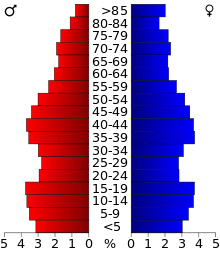
As of the 2010 United States Census, there were 67,103 people, 27,375 households, and 17,677 families residing in the county.[12] The population density was 78.5 inhabitants per square mile (30.3/km2). There were 29,842 housing units at an average density of 34.9 per square mile (13.5/km2).[6] The racial makeup of the county was 93.7% white, 3.5% black or African American, 0.7% Asian, 0.2% American Indian, 0.4% from other races, and 1.6% from two or more races. Those of Hispanic or Latino origin made up 1.2% of the population.[12] In terms of ancestry, 43.5% were German, 13.1% were Irish, 10.7% were American, and 8.7% were English.[13]
Of the 27,375 households, 29.9% had children under the age of 18 living with them, 50.0% were married couples living together, 10.7% had a female householder with no husband present, 35.4% were non-families, and 30.1% of all households were made up of individuals. The average household size was 2.37 and the average family size was 2.94. The median age was 40.7 years.[12]
The median income for a household in the county was $43,824 and the median income for a family was $55,791. Males had a median income of $38,830 versus $29,371 for females. The per capita income for the county was $24,308. About 8.3% of families and 12.3% of the population were below the poverty line, including 17.5% of those under age 18 and 8.1% of those age 65 or over.[14]
Communities

City
Villages
Unincorporated communities
Townships
Adams County is divided into twenty-three townships:
Politics
| Adams County, Illinois | |||||||
|---|---|---|---|---|---|---|---|
| Elected countywide officials | |||||||
| Circuit Clerk | Lori Geschwandner | Democratic | |||||
| County Clerk | Chuck Venvertloh | Republican | |||||
| Coroner | James Keller | Republican | |||||
| Sheriff | Brent Fischer | Democratic | |||||
| State’s Attorney | Jonathan Barnard | Republican | |||||
| Regional Superintendent | Deborah Niederhauser | Republican | |||||
| Treasurer | Terry Asher | Republican | |||||
| Year | Republican | Democratic | Third Parties |
|---|---|---|---|
| 2016 | 70.5% 22,790 | 23.8% 7,676 | 5.7% 1,844 |
| 2012 | 66.5% 20,416 | 31.4% 9,648 | 2.1% 633 |
| 2008 | 60.6% 18,711 | 38.2% 11,794 | 1.3% 397 |
| 2004 | 66.2% 20,834 | 33.4% 10,511 | 0.4% 132 |
| 2000 | 57.6% 17,331 | 40.5% 12,197 | 1.9% 581 |
| 1996 | 48.7% 13,836 | 39.9% 11,336 | 11.4% 3,239 |
| 1992 | 42.8% 13,529 | 37.2% 11,748 | 20.0% 6,302 |
| 1988 | 53.3% 15,831 | 46.3% 13,768 | 0.4% 111 |
| 1984 | 66.0% 20,225 | 33.7% 10,336 | 0.3% 88 |
| 1980 | 62.2% 19,842 | 33.2% 10,606 | 4.6% 1,469 |
| 1976 | 59.7% 18,189 | 39.1% 11,926 | 1.2% 370 |
| 1972 | 69.5% 20,731 | 30.3% 9,055 | 0.2% 60 |
| 1968 | 54.3% 17,444 | 35.9% 11,521 | 9.8% 3,143 |
| 1964 | 43.3% 13,993 | 56.7% 18,321 | 0.0% 0 |
| 1960 | 55.7% 18,674 | 44.2% 14,827 | 0.1% 28 |
| 1956 | 63.1% 19,569 | 36.8% 11,402 | 0.1% 32 |
| 1952 | 59.6% 19,652 | 40.3% 13,301 | 0.1% 21 |
| 1948 | 48.7% 14,329 | 50.8% 14,960 | 0.5% 152 |
| 1944 | 52.9% 15,564 | 46.7% 13,733 | 0.5% 142 |
| 1940 | 50.9% 18,480 | 47.8% 17,361 | 1.4% 492 |
| 1936 | 39.2% 13,114 | 56.3% 18,857 | 4.5% 1,502 |
| 1932 | 32.0% 10,134 | 66.6% 21,098 | 1.4% 437 |
| 1928 | 53.6% 15,590 | 45.4% 13,215 | 1.0% 288 |
| 1924 | 40.9% 9,985 | 35.4% 8,628 | 23.7% 5,791 |
| 1920 | 57.1% 12,852 | 32.1% 7,222 | 10.9% 2,447 |
| 1916 | 44.2% 11,858 | 53.2% 14,268 | 2.5% 682 |
| 1912 | 26.5% 3,780 | 48.7% 6,952 | 24.8% 3,531 |
| 1908 | 44.3% 7,233 | 50.8% 8,294 | 4.8% 787 |
| 1904 | 49.1% 7,277 | 41.5% 6,149 | 9.5% 1,408 |
| 1900 | 46.8% 8,047 | 51.4% 8,844 | 1.8% 301 |
| 1896 | 50.3% 8,447 | 47.8% 8,025 | 2.0% 336 |
| 1892 | 42.0% 6,081 | 53.5% 7,746 | 4.5% 657 |
Adams County, positioned in a primarily rural section of Illinois is culturally isolated from Chicago, and therefore more conservative than the state's northeastern corner. Quincy, the county seat, holds a high number of socially conservative Catholics[16] and likewise is the home to the campus of Quincy University, a private Catholic liberal arts college, and the Western Catholic Union.
The county is part of the historic belt of German settlement extending into the Missouri Rhineland and because it was antagonistic to the Yankee northeast of Illinois, it voted solidly Democratic until 1892. After being a swing county in the first half of the twentieth century, Adams County has been a Republican stronghold. It last supported a Democrat for President of the United States in 1964, when it voted for (Lyndon Johnson. The county regularly rejects Democrats at the state level as well; it hasn't supported a Democrat for Governor of Illinois since Adlai Stevenson II in 1948.[17] Notably, while it warmly supported Barack Obama in his 2004 Senate campaign, it shut Obama out in both his presidential bids.
The county is currently represented in the U.S. House of Representatives by Republican Darin LaHood. For the Illinois House of Representatives, the county is located in the 94th district and is currently represented by Republican Randy Frese. The county is located in the 47th district of the Illinois Senate, and is currently represented by Republican Jil Tracy.
Education
Unified school districts
Private schools
- Blessed Sacrament Catholic School
- Chaddock School
- Quincy Christian School
- Quincy Notre Dame High School
- St. Dominic Catholic School
- St. Francis Solanus Catholic School
- St. James Lutheran School
- St. Peter Catholic School
Colleges and universities
- Blessing-Rieman College of Nursing
- John Wood Community College
- Quincy University
Attractions
- Adams County Fair
- Bayview Bridge
- Burton Cave
- Fall Creek Scenic Park
- Golden Windmill
- John Wood Mansion
- Saukenauk Scout Reservation
- Siloam Springs State Park
- Spirit Knob Winery
- Villa Katharine
- Wavering Park
See also
References
- ↑ "Population and Housing Unit Estimates". U.S. Census Bureau. August 15, 2017. Retrieved August 15, 2017.
- 1 2 "State & County QuickFacts". United States Census Bureau. Archived from the original on July 6, 2011. Retrieved July 3, 2014.
- ↑ "Find a County". National Association of Counties. Archived from the original on 2011-05-31. Retrieved 2011-06-07.
- ↑ White, Jesse. Origin and Evolution of Illinois Counties. State of Illinois, March 2010.
- 1 2 "Monthly Averages for Quincy, Illinois". The Weather Channel. Retrieved 2011-01-27.
- 1 2 "Population, Housing Units, Area, and Density: 2010 - County". United States Census Bureau. Retrieved 2015-07-11.
- ↑ "Population and Housing Unit Estimates". Retrieved June 9, 2017.
- ↑ "U.S. Decennial Census". United States Census Bureau. Archived from the original on May 12, 2015. Retrieved July 3, 2014.
- ↑ "Historical Census Browser". University of Virginia Library. Retrieved July 3, 2014.
- ↑ "Population of Counties by Decennial Census: 1900 to 1990". United States Census Bureau. Retrieved July 3, 2014.
- ↑ "Census 2000 PHC-T-4. Ranking Tables for Counties: 1990 and 2000" (PDF). United States Census Bureau. Retrieved July 3, 2014.
- 1 2 3 "DP-1 Profile of General Population and Housing Characteristics: 2010 Demographic Profile Data". United States Census Bureau. Retrieved 2015-07-11.
- ↑ "DP02 SELECTED SOCIAL CHARACTERISTICS IN THE UNITED STATES – 2006-2010 American Community Survey 5-Year Estimates". United States Census Bureau. Retrieved 2015-07-11.
- ↑ "DP03 SELECTED ECONOMIC CHARACTERISTICS – 2006-2010 American Community Survey 5-Year Estimates". United States Census Bureau. Retrieved 2015-07-11.
- ↑ http://uselectionatlas.org/RESULTS
- ↑ http://www.thearda.com/mapsReports/reports/counties/17001_2000.asp
- ↑ "Adams County Clerk".
External links
| Wikimedia Commons has media related to Adams County, Illinois. |
| Wikivoyage has a travel guide for Adams County (Illinois). |
- Adams County website
- Adams County GIS Website
- Great River Genealogical Society
- United States Census Bureau 2007 TIGER/Line Shapefiles
- United States Board on Geographic Names (GNIS)
- United States National Atlas
Places adjacent to Adams County, Illinois | ||||||||||
|---|---|---|---|---|---|---|---|---|---|---|
| ||||||||||
Municipalities and communities of Adams County, Illinois, United States | ||
|---|---|---|
| City | ||
| Town | ||
| Villages | ||
| Townships | ||
| Unincorporated communities | ||
