List of counties in New York (state)
| Counties of New York | |
|---|---|
 | |
| Location | State of New York |
| Number | 62 |
| Populations | 4,836 (Hamilton) – 2,504,700 (Kings County) |
| Areas | 33.77 square miles (87.5 km2) (New York) – 2,821 square miles (7,310 km2) (St. Lawrence) |
| Government | County government |
| Subdivisions | Cities, Towns, Indian Reservations |
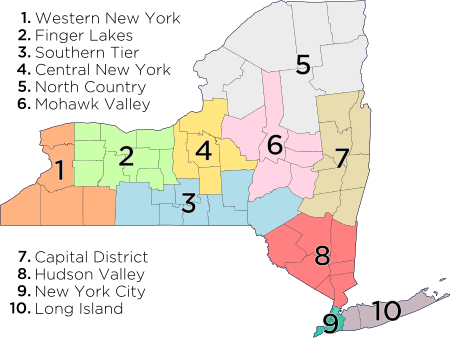
| Part of a series on |
| Regions of New York |
|---|
 |
|
|
Timelines of town creation
|
There are 62 counties in the state of New York. The original twelve counties were created immediately after the British takeover of the Dutch colony of New Amsterdam, although two of these counties have since been abolished. The most recent county formation in New York was in 1914, when Bronx County was created from the portions of New York City that had been annexed from Westchester County in the late 19th century and added to New York County.[1] New York's counties are named for a variety of Native American words; British provinces, counties, cities, and royalty; early American statesmen and military personnel; and New York State politicians.[2]
The FIPS county code is the five-digit Federal Information Processing Standard (FIPS) code which uniquely identifies counties and county equivalents in the United States. The three-digit number is unique to each individual county within a state, but to be unique within the entire United States, it must be prefixed by the state code. This means that, for example, while Albany County is 001, Addison County, Vermont, and Alachua County, Florida, are also 001. To uniquely identify Albany County, New York, one must use the state code of 36 plus the county code of 001; therefore, the unique nationwide identifier for Albany County, New York, is 36001. The links in the column FIPS County Code are to the Census Bureau Info page for that county.[3]
Five boroughs of New York City
Five of New York's counties are each coextensive with New York City's five boroughs and do not have county governments. They are New York County (Manhattan), Kings County (Brooklyn), Bronx County (The Bronx), Richmond County (Staten Island), and Queens County (Queens).
In contrast to other counties of New York state, the powers of the five boroughs of New York City are very limited and in nearly all respects are governed by the city government.[4] Only a few officials are elected on a borough-wide basis, such as the five borough presidents, district attorneys, and some judges. There are no official county seats, but the locations of borough halls and courthouses bestow certain neighborhoods an informal designation as county seats within their boroughs:
- The Bronx County Courthouse and the borough's main post office are located in the South Bronx. There is no longer a separate Bronx Borough Hall.
- Brooklyn Borough Hall, the Federal Building and Post Office, and county Supreme Court are in Downtown Brooklyn.
- The Municipal Building, where the Manhattan Borough President's office is located, and most courthouses are in the downtown Civic Center. The General Post Office is in Midtown Manhattan.
- Queens Borough Hall and a courthouse are in Kew Gardens. Another major courthouse, post office, and the Long Island Railroad hub are in Jamaica. Queens also has general post offices in Flushing, Long Island City and Far Rockaway.
- Staten Island Borough Hall, three courthouses, and the St. George Terminal transportation hub are in the St. George neighborhood.
Alphabetical list
| County |
FIPS Code [3] |
County seat [5] |
Created [5] |
Formed from [1] |
Named for [2] |
Density |
2010 Population [5] |
Area [5] |
Map |
|---|---|---|---|---|---|---|---|---|---|
| Albany County | 001 | Albany | 1683 | One of 12 original counties created in the New York colony | James II of England (James VII of Scotland) (1633–1701), who was Duke of York (English title) and Duke of Albany (Scottish title) before becoming King of England, Ireland, and Scotland. | 570.74 | 304,204 | 533 sq mi (1,380 km2) | 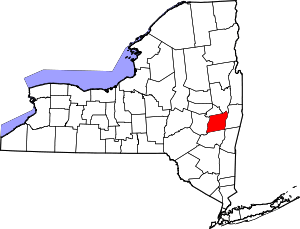 |
| Allegany County | 003 | Belmont | 1806 | Genesee County | A variant spelling of the Allegheny River | 47.34 | 48,946 | 1,034 sq mi (2,678 km2) | 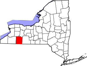 |
| Bronx County | 005 | none | 1914[6] | New York County | Jonas Bronck (1600?–1643), an early settler of the Dutch colony of New Amsterdam | 24,118.20 | 1,385,108 | 57.43 sq mi (149 km2) |  |
| Broome County | 007 | Binghamton | 1806 | Tioga County | John Broome (1738–1810), fourth Lieutenant Governor of New York | 280.56 | 200,600 | 715 sq mi (1,852 km2) | 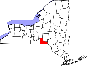 |
| Cattaraugus County | 009 | Little Valley | 1808 | Genesee County | A Seneca word meaning "bad smelling banks", referring to the odor of natural gas which leaked from local rock formations | 61.31 | 80,317 | 1,310 sq mi (3,393 km2) | 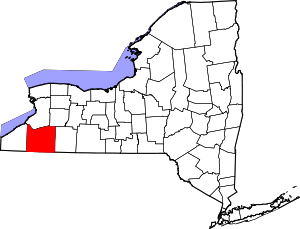 |
| Cayuga County | 011 | Auburn | 1799 | Onondaga County | The Cayuga tribe of Native Americans | 92.62 | 80,026 | 864 sq mi (2,238 km2) | 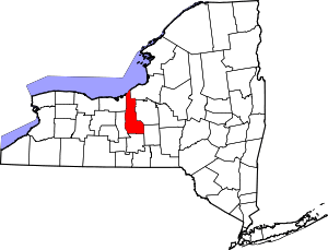 |
| Chautauqua County | 013 | Mayville | 1808 | Genesee County | Loanword from the Erie language describing Chautauqua Lake; language now lost and cannot be translated | 89.94 | 134,905 | 1,500 sq mi (3,885 km2) | 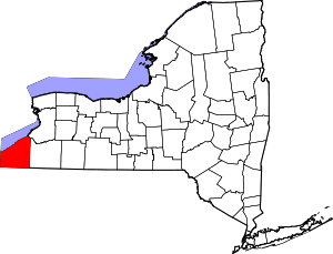 |
| Chemung County | 015 | Elmira | 1836 | Tioga County | A Lenape word meaning "big horn", which was the name of a local Native American village | 216.23 | 88,830 | 410.81 sq mi (1,064 km2) | 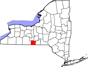 |
| Chenango County | 017 | Norwich | 1798 | Tioga County and Herkimer County | An Onondaga word meaning "large bull-thistle" | 56.16 | 50,477 | 898.85 sq mi (2,328 km2) | 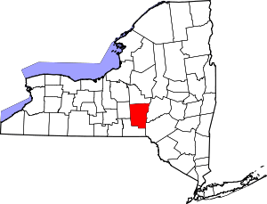 |
| Clinton County | 019 | Plattsburgh | 1788 | Washington County | George Clinton (1739–1812), fourth Vice President of the United States and first and third Governor of New York | 73.46 | 82,128 | 1,118 sq mi (2,896 km2) | 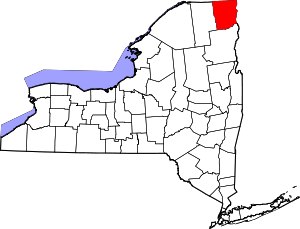 |
| Columbia County | 021 | Hudson | 1786 | Albany County | Christopher Columbus (1451–1506), the European explorer | 97.37 | 63,096 | 648 sq mi (1,678 km2) | 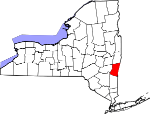 |
| Cortland County | 023 | Cortland | 1808 | Onondaga County | Pierre Van Cortlandt (1721–1814), first Lieutenant Governor of New York | 98.28 | 49,336 | 502 sq mi (1,300 km2) | 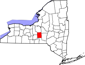 |
| Delaware County | 025 | Delhi | 1797 | Otsego County and Ulster County | Thomas West, 3rd Baron De La Warr (1577–1618), an early colonial leader in Virginia | 32.68 | 47,980 | 1,468 sq mi (3,802 km2) | 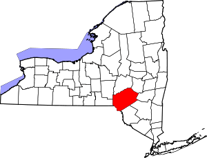 |
| Dutchess County | 027 | Poughkeepsie | 1683 | One of 12 original counties created in the New York colony | Lady Anne Hyde (1637–1671), Duchess of York and wife of King James II of England | 360.59 | 297,488 | 825 sq mi (2,137 km2) | 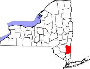 |
| Erie County | 029 | Buffalo | 1821 | Niagara County | The Erie tribe of Native Americans | 749.02 | 919,040 | 1,227 sq mi (3,178 km2) | 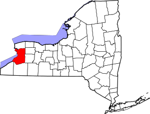 |
| Essex County | 031 | Elizabethtown | 1799 | Clinton County | The county of Essex in England | 20.55 | 39,370 | 1,916 sq mi (4,962 km2) | 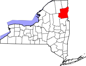 |
| Franklin County | 033 | Malone | 1808 | Clinton County | Benjamin Franklin (1706–1790), the early American printer, scientist, and statesman | 30.41 | 51,599 | 1,697 sq mi (4,395 km2) | 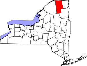 |
| Fulton County | 035 | Johnstown | 1838 | Montgomery County | Robert Fulton (1765–1815), inventor of the steamship | 104.19 | 55,531 | 533 sq mi (1,380 km2) | 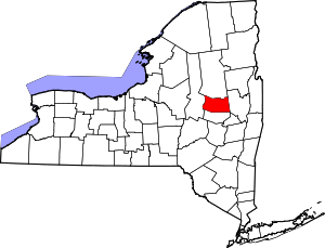 |
| Genesee County | 037 | Batavia | 1802 | Ontario County and land acquired in the Holland Purchase | A Seneca phrase meaning "good valley" | 121.37 | 60,079 | 495 sq mi (1,282 km2) | 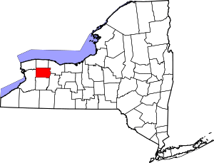 |
| Greene County | 039 | Catskill | 1800 | Albany County and Ulster County | Nathanael Greene (1742–1786), the American Revolutionary War general | 74.80 | 49,221 | 658 sq mi (1,704 km2) | 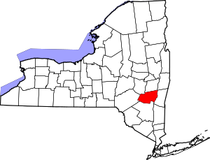 |
| Hamilton County | 041 | Lake Pleasant | 1816 | Montgomery County | Alexander Hamilton (1755–1804), the early American political theorist and first Secretary of the Treasury | 2.67 | 4,836 | 1,808 sq mi (4,683 km2) | 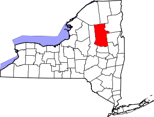 |
| Herkimer County | 043 | Herkimer | 1791 | Montgomery County | Nicholas Herkimer (1728–1777), the American Revolutionary War general | 44.25 | 64,519 | 1,458 sq mi (3,776 km2) | 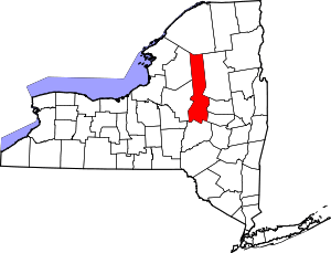 |
| Jefferson County | 045 | Watertown | 1805 | Oneida County | Thomas Jefferson (1743–1826), the early American statesman, author of the Declaration of Independence, and third President of the United States | 62.59 | 116,229 | 1,857 sq mi (4,810 km2) | 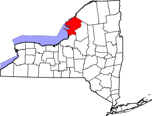 |
| Kings County | 047 | none | 1683 | One of 12 original counties created in the New York colony | King Charles II of England (1630–1685) | 25,848.30 | 2,504,700 | 96.9 sq mi (251 km2) |  |
| Lewis County | 049 | Lowville | 1805 | Oneida County | Morgan Lewis (1754–1844), the fourth Governor of New York | 21.00 | 27,087 | 1,290 sq mi (3,341 km2) | 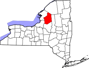 |
| Livingston County | 051 | Geneseo | 1821 | Genesee County and Ontario County | Robert Livingston (1746–1813), the early American statesman and New York delegate to the Continental Congress | 102.18 | 65,393 | 640 sq mi (1,658 km2) | 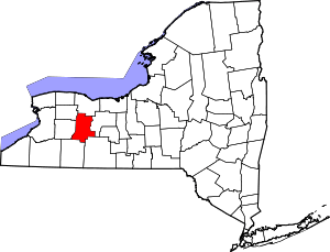 |
| Madison County | 053 | Wampsville | 1806 | Chenango County | James Madison (1751–1836), the early American statesman, principal author of the Constitution of the United States, and fourth President of the United States | 110.94 | 73,442 | 662 sq mi (1,715 km2) | 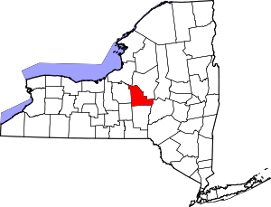 |
| Monroe County | 055 | Rochester | 1821 | Genesee County and Ontario County | James Monroe (1758–1831), the early American statesman and fifth President of the United States | 544.91 | 744,344 | 1,366 sq mi (3,538 km2) | 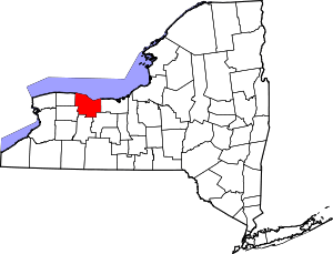 |
| Montgomery County | 057 | Fonda | 1772 | Albany County | Originally Tryon County after colonial governor William Tryon (1729–1788), renamed after the American Revolutionary War general Richard Montgomery (1738–1775) in 1784 | 122.49 | 50,219 | 410 sq mi (1,062 km2) | 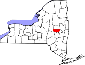 |
| Nassau County | 059 | Mineola | 1899 | Queens County | The Princes of Orange-Nassau ruled the Netherlands when Long Island was a Dutch colony | 2,957.02 | 1,339,532 | 453 sq mi (1,173 km2) | 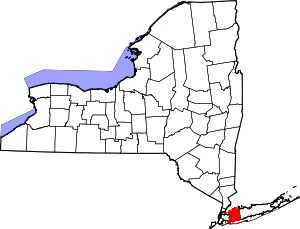 |
| New York County | 061 | none | 1683 | One of 12 original counties created in the New York colony | King James II of England (1633–1701), who was Duke of York and Albany before he ascended the throne of England, Duke of York being his English title | 46,961.00 | 1,585,873 | 33.77 sq mi (87 km2) |  |
| Niagara County | 063 | Lockport | 1808 | Genesee County | An Iroquoian word perhaps meaning "a neck" between two bodies of water, "thunder of waters", or "bisected bottom land" | 189.89 | 216,469 | 1,140 sq mi (2,953 km2) | 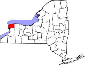 |
| Oneida County | 065 | Utica | 1798 | Herkimer County | The Oneida tribe of Native Americans | 193.63 | 234,878 | 1,213 sq mi (3,142 km2) | 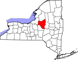 |
| Onondaga County | 067 | Syracuse | 1792 | Herkimer County | The Onondaga tribe of Native Americans | 579.44 | 467,026 | 806 sq mi (2,088 km2) | 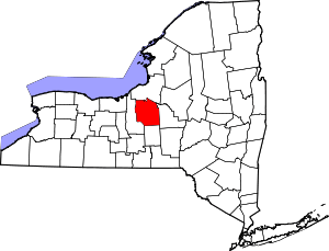 |
| Ontario County | 069 | Canandaigua | 1789 | Land acquired in the Phelps and Gorham Purchase | An Iroquoian word meaning "beautiful lake" | 163.04 | 107,931 | 662 sq mi (1,715 km2) | 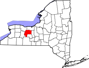 |
| Orange County | 071 | Goshen | 1683 | One of 12 original counties created in the New York colony | William of Orange-Nassau (1650–1702), who became King William III of England | 444.35 | 372,813 | 839 sq mi (2,173 km2) | 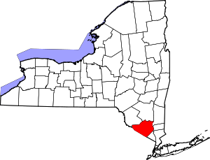 |
| Orleans County | 073 | Albion | 1824 | Genesee County | The French Royal House of Orléans | 52.49 | 42,883 | 817 sq mi (2,116 km2) | 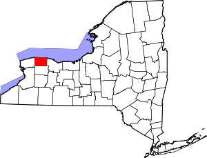 |
| Oswego County | 075 | Oswego | 1816 | Oneida County and Onondaga County | The Oswego River, from an Iroquoian word meaning "the outpouring", referring to the mouth of the river | 93.07 | 122,109 | 1,312 sq mi (3,398 km2) | 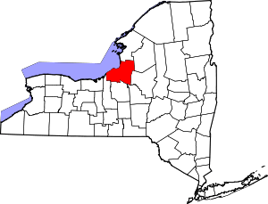 |
| Otsego County | 077 | Cooperstown | 1791 | Montgomery County | A Native American word meaning "place of the rock" | 62.07 | 62,259 | 1,003 sq mi (2,598 km2) | 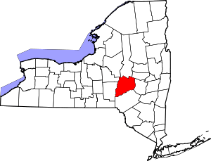 |
| Putnam County | 079 | Carmel | 1812 | Dutchess County | Israel Putnam (1718–1790), an American Revolutionary War general | 405.33 | 99,710 | 246 sq mi (637 km2) | 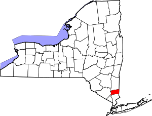 |
| Queens County | 081 | none | 1683 | One of 12 original counties created in the New York colony | Catherine of Braganza (1638–1705), Queen of England and wife of King Charles II of England | 12,512.46 | 2,230,722 | 178.28 sq mi (462 km2) | 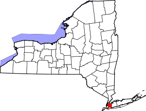 |
| Rensselaer County | 083 | Troy | 1791 | Albany County | In honor of the family of Kiliaen van Rensselaer (before 1596 – after 1643), the early landholder in the Dutch New Amsterdam colony | 239.74 | 159,429 | 665 sq mi (1,722 km2) | 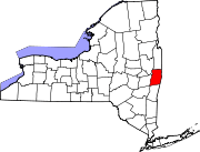 |
| Richmond County | 085 | none | 1683 | One of 12 original counties created in the New York colony | Charles Lennox, 1st Duke of Richmond (1672–1723), the illegitimate son of King Charles II of England | 4,572.98 | 468,730 | 102.5 sq mi (265 km2) |  |
| Rockland County | 087 | New City | 1798 | Orange County | Early settlers' description of terrain as "rocky land" | 1,566.27 | 311,687 | 199 sq mi (515 km2) | 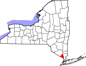 |
| St. Lawrence County | 089 | Canton | 1802 | Clinton County, Herkimer County, and Montgomery County | The St Lawrence River, which forms the northern border of the county and New York State | 39.68 | 111,944 | 2,821 sq mi (7,306 km2) | 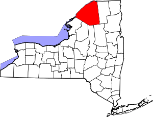 |
| Saratoga County | 091 | Ballston Spa | 1791 | Albany County | A corruption of a Native American word meaning "the hill beside the river" | 260.20 | 219,607 | 844 sq mi (2,186 km2) | 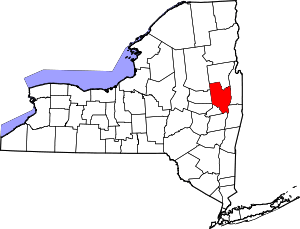 |
| Schenectady County | 093 | Schenectady | 1809 | Albany County | A Mohawk word meaning "on the other side of the pine lands" | 736.80 | 154,727 | 210 sq mi (544 km2) | 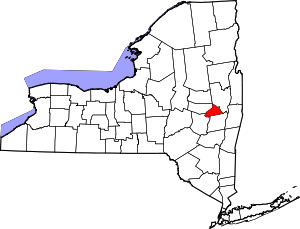 |
| Schoharie County | 095 | Schoharie | 1795 | Albany County and Otsego County | A Mohawk word meaning "floating driftwood" | 51.84 | 32,749 | 626 sq mi (1,621 km2) | 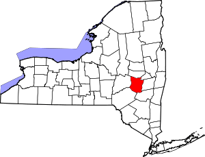 |
| Schuyler County | 097 | Watkins Glen | 1854 | Chemung County, Steuben County, and Tompkins County | Philip Schuyler (1733–1804), the American Revolutionary War general and Senator from New York | 53.63 | 18,343 | 342 sq mi (886 km2) | 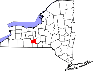 |
| Seneca County | 099 | Waterloo | 1804 | Cayuga County | The Seneca tribe of Native Americans | 108.46 | 35,251 | 325 sq mi (842 km2) | 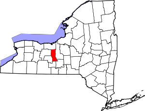 |
| Steuben County | 101 | Bath | 1796 | Ontario County | Friedrich Wilhelm von Steuben (1730–1794), the Prussian general who assisted the Continental Army during the American Revolutionary War | 70.51 | 98,990 | 1,404 sq mi (3,636 km2) | 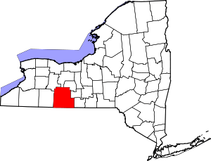 |
| Suffolk County | 103 | Riverhead | 1683 | One of 12 original counties created in the New York colony | The county of Suffolk in England | 629.31 | 1,493,350 | 2,373 sq mi (6,146 km2) | 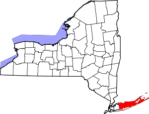 |
| Sullivan County | 105 | Monticello | 1809 | Ulster County | John Sullivan (1740–1795), an American Revolutionary War general | 77.78 | 77,547 | 997 sq mi (2,582 km2) | 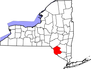 |
| Tioga County | 107 | Owego | 1791 | Montgomery County | A Native American word meaning "at the forks", describing a meeting place | 97.75 | 51,125 | 523 sq mi (1,355 km2) | 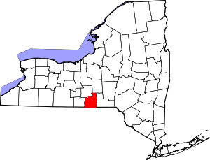 |
| Tompkins County | 109 | Ithaca | 1817 | Cayuga County and Seneca County | Daniel D. Tompkins (1774–1825), the 6th Vice President of the United States | 213.37 | 101,564 | 476 sq mi (1,233 km2) |  |
| Ulster County | 111 | Kingston | 1683 | One of 12 original counties created in the New York colony | The Irish province of Ulster, then an earldom of the Duke of York, later King James II of England | 157.19 | 182,493 | 1,161 sq mi (3,007 km2) | 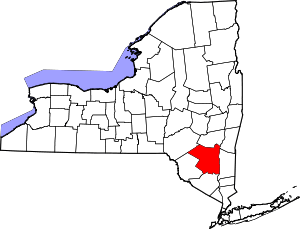 |
| Warren County | 113 | Queensbury | 1813 | Washington County | Joseph Warren (1741–1775), the early American patriot and American Revolutionary War general | 75.53 | 65,707 | 870 sq mi (2,253 km2) | 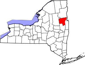 |
| Washington County | 115 | Fort Edward | 1772 | Albany County | Originally Charlotte County, renamed in 1784 after George Washington (1732–1799), the American Revolutionary War general and first President of the United States | 74.72 | 63,216 | 846 sq mi (2,191 km2) | 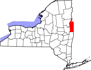 |
| Wayne County | 117 | Lyons | 1823 | Ontario County and Seneca County | General Anthony Wayne (1745–1796), the American Revolutionary War general | 67.75 | 93,772 | 1,384 sq mi (3,585 km2) | 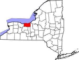 |
| Westchester County | 119 | White Plains | 1683 | One of 12 original counties created in the New York colony | The city of Chester in England | 1,898.23 | 949,113 | 500 sq mi (1,295 km2) | 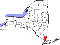 |
| Wyoming County | 121 | Warsaw | 1841 | Genesee County | A modification of a word from the Lenape language meaning "broad bottom lands" | 70.73 | 42,155 | 596 sq mi (1,544 km2) | 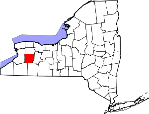 |
| Yates County | 123 | Penn Yan | 1823 | Ontario County and Steuben County | Joseph C. Yates (1768–1837), eighth Governor of New York | 67.41 | 25,348 | 376 sq mi (974 km2) | 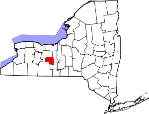 |
Defunct counties
| County |
Created [1] |
Abolished [1] |
Fate[1] |
|---|---|---|---|
| Charlotte County | 1772 | 1784 | Partitioned and renamed as Washington County |
| Cornwall County | 1665 | 1686 | Transferred to the part of Massachusetts that later became the state of Maine and partitioned; one of the 12 original counties created in the New York colony |
| Cumberland County | 1766 | 1777 | Transferred to Vermont and partitioned |
| Dukes County | 1683 | 1692 | Transferred to Massachusetts; one of 12 original counties created in the New York colony |
| Gloucester County | 1770 | 1777 | Transferred to Vermont and partitioned |
| Mexico County | 1792 | 1796 | Never settled or incorporated, reallocated to other counties |
| Tryon County | 1772 | 1784 | Renamed as Montgomery County |
Proposed new counties
| County |
Note |
|---|---|
| Adirondack County | Would hypothetically consist of portions of northern Essex County and southern Franklin County[7] |
| Brookhaven County | Would hypothetically consist of the existing Town of Brookhaven, New York in Suffolk County on Long Island. |
| Peconic County | Would hypothetically consist of the five easternmost towns in Suffolk County on Long Island.[8] |
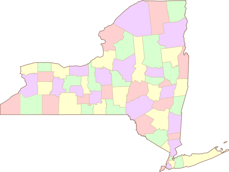
Clickable map
See also
References
- 1 2 3 4 5 "New York Formation Maps". Genealogy, Inc. Archived from the original on December 30, 2007. Retrieved 2008-01-20.
- 1 2 Beatty, Michael (2001). County Name Origins of the United States. McFarland Press. ISBN 0-7864-1025-6.
- 1 2 "EPA County FIPS Code Listing". US Environmental Protection Agency. Archived from the original on 2012-10-08. Retrieved 2007-07-24.
- ↑ Benjamin, Gerald; Nathan, Richard P. (1990). Regionalism and realism: A Study of Government in the New York Metropolitan Area. Brookings Institution. p. 59.
- 1 2 3 4 "Find A County". National Association of Counties. Archived from the original on August 4, 2010. Retrieved August 9, 2010.
- ↑ Legislation splitting off Bronx County from New York County was enacted in 1912 with an effective date of January 1, 1914. Prior to 1874 the entire area had been part of Westchester County. See McCarthy, Thomas C. "A 5-Borough Centennial Preface for the Katharine Bement Davis Mini-History". New York City Department of Corrections. Retrieved 2008-01-25.
- ↑ Lynch, Mike (2007-10-30). "North Elba Supervisor Candidate Debate". Plattsburgh Press Republican. Retrieved 2008-01-20.
- ↑ Healy, Patrick (2004-02-11). "Growth Pains and Clout Heading East in Suffolk". The New York Times. Retrieved 2008-01-20.