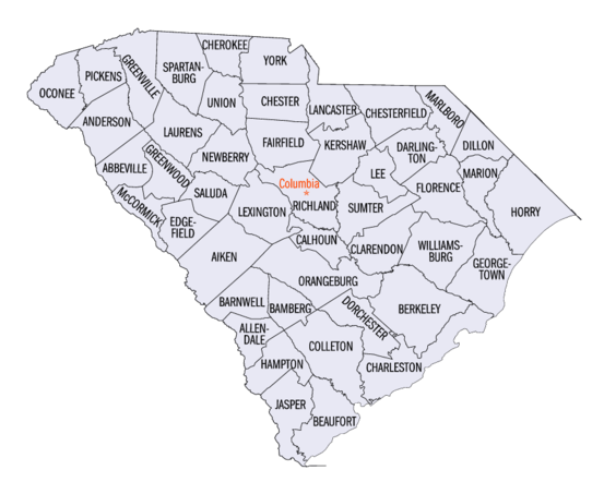
List of counties in South Carolina
| Counties of South Carolina | |
|---|---|
 | |
| Location | State of South Carolina |
| Number | 46 |
| Populations | 9,958 (McCormick) – 498,766 (Greenville) |
| Areas | 392 square miles (1,020 km2) (Calhoun) – 1,358 square miles (3,520 km2) (Charleston) |
| Government | County government |
| Subdivisions | cities, towns, unincorporated communities, census designated place |
The U.S. state of South Carolina is made up of 46 counties, the maximum allowable by state law.[1] They range in size from 359 square miles (930 square kilometers) in the case of Calhoun County to 1,358 square miles (3,517 square kilometers) in the case of Charleston County. The least populous county is McCormick County, with only 9,958 residents, while the most populous county is Greenville County, with a population of 498,776, despite the state's most populous city, Columbia, being located in Richland County.
History
In the colonial period, the land around the coast was divided into parishes corresponding to the parishes of the Church of England. There were also several counties that had judicial and electoral functions. As people settled the backcountry, judicial districts and additional counties were formed. This structure continued and grew after the Revolutionary War. In 1800, all counties were renamed as districts. In 1868, the districts were converted back to counties.[2] The South Carolina Department of Archives and History has maps that show the boundaries of counties, districts, and parishes starting in 1682.[3]
Alphabetical list
| County |
FIPS code[4] | County seat[5] | Established[5] | Origin | Etymology | Population | Area | Map |
|---|---|---|---|---|---|---|---|---|
| Abbeville County | 001 | Abbeville | 1785 | Ninety-Six District | Abbeville, France | 24,872 | 511 sq mi (1,323 km2) | 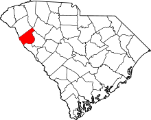 |
| Aiken County | 003 | Aiken | 1871 | Barnwell, Edgefield, Lexington, and Orangeburg | William Aiken, founder of the South Carolina Canal and Railroad Company | 167,458 | 1,080 sq mi (2,797 km2) | 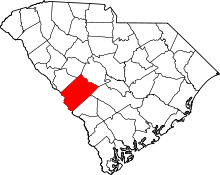 |
| Allendale County | 005 | Allendale | 1919 | Barnwell and Hampton | P.H. Allen, first postmaster of the new county | 9,045 | 413 sq mi (1,070 km2) | 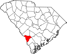 |
| Anderson County | 007 | Anderson | 1826 | Pendleton District | Robert Anderson, American Revolutionary War general and Southern surveyor | 196,569 | 757 sq mi (1,961 km2) | 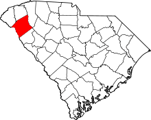 |
| Bamberg County | 009 | Bamberg | 1897 | Barnwell | Francis Marion Bamberg (1838 - 1905), Confederate general in the American Civil War | 14,434 | 395 sq mi (1,023 km2) | 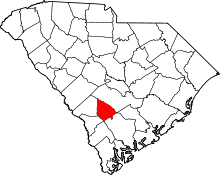 |
| Barnwell County | 011 | Barnwell | 1798 | Orangeburg | John Barnwell, South Carolina State Senator and prisoner of war during the American Revolution | 21,483 | 557 sq mi (1,443 km2) | 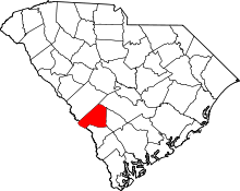 |
| Beaufort County | 013 | Beaufort | 1769 | 1769 Judicial District | Henry Somerset, 1st Duke of Beaufort, colonial proprietary landowner | 183,149 | 576 sq mi (1,492 km2) | 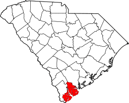 |
| Berkeley County | 015 | Moncks Corner | 1882 | Charleston | William Berkeley, colonial proprietary governor and landowner | 210,898 | 1,228 sq mi (3,181 km2) | 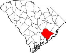 |
| Calhoun County | 017 | St. Matthews | 1908 | Lexington and Orangeburg | John C. Calhoun, U.S. Senator from South Carolina and states' rights advocate | 14,796 | 392 sq mi (1,015 km2) | 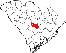 |
| Charleston County | 019 | Charleston | 1769 | 1769 Judicial District | King Charles II of England | 396,484 | 1,358 sq mi (3,517 km2) | 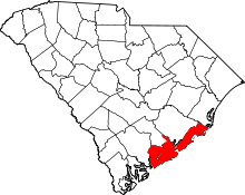 |
| Cherokee County | 021 | Gaffney | 1897 | Spartanburg, Union, and York | Cherokee Native Americans | 56,646 | 397 sq mi (1,028 km2) | 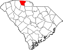 |
| Chester County | 023 | Chester | 1785 | Camden District | Chester, Pennsylvania | 32,181 | 586 sq mi (1,518 km2) | 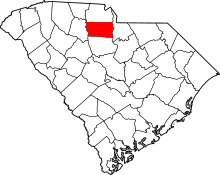 |
| Chesterfield County | 025 | Chesterfield | 1798 | Cheraws District | Philip Dormer Stanhope, 4th Earl of Chesterfield, an Enlightenment-era scholar, government official, and member of the British House of Lords | 46,013 | 806 sq mi (2,088 km2) | 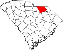 |
| Clarendon County | 027 | Manning | 1855 | Sumter | Edward Hyde, 1st Earl of Clarendon, colonial proprietary landowner | 33,951 | 696 sq mi (1,803 km2) | 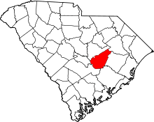 |
| Colleton County | 029 | Walterboro | 1800 | Charleston | John Colleton, colonial proprietary landowner | 37,923 | 1,133 sq mi (2,934 km2) | 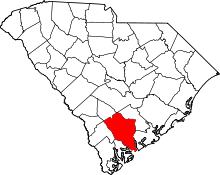 |
| Darlington County | 031 | Darlington | 1785 | Cheraws District | Darlington, England | 67,234 | 567 sq mi (1,469 km2) | 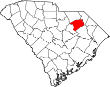 |
| Dillon County | 033 | Dillon | 1910 | Marion | J.W. Dillon, founder of the Wilson Short Cut Railroad | 30,858 | 407 sq mi (1,054 km2) | 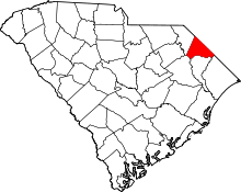 |
| Dorchester County | 035 | St. George | 1868 | Berkeley and Colleton | Dorchester, Massachusetts | 153,773 | 577 sq mi (1,494 km2) | 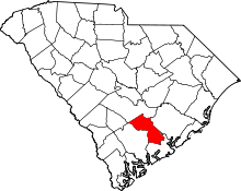 |
| Edgefield County | 037 | Edgefield | 1785 | Ninety-Six District | Disputed; either its location on the edge of the state or Edgefield, Norfolk, England | 26,358 | 507 sq mi (1,313 km2) | 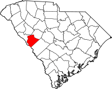 |
| Fairfield County | 039 | Winnsboro | 1785 | Camden District | The county's fair fields, as described by colonial governor Charles Cornwallis | 22,653 | 710 sq mi (1,839 km2) | 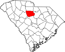 |
| Florence County | 041 | Florence | 1888 | Clarendon, Darlington, Marion, and Williamsburg | Florence Harllee, daughter of Wilmington and Manchester Railroad founder W.W. Harllee | 138,742 | 804 sq mi (2,082 km2) | 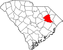 |
| Georgetown County | 043 | Georgetown | 1769 | 1769 Judicial District | King George II of Great Britain | 61,399 | 813.55 sq mi (2,107 km2) | 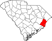 |
| Greenville County | 045 | Greenville | 1786 | Washington District | Nathanael Greene, Revolutionary War general | 498,766 | 795 sq mi (2,059 km2) | 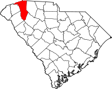 |
| Greenwood County | 047 | Greenwood | 1897 | Abbeville and Edgefield | Greenwood Plantation, the home of John McGee, the county's largest landowner | 70,133 | 463 sq mi (1,199 km2) | 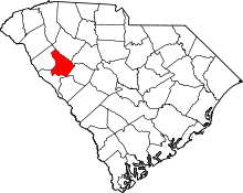 |
| Hampton County | 049 | Hampton | 1787 | Beaufort | Wade Hampton, Congressman from South Carolina and once the nation's wealthiest citizen | 19,922 | 563 sq mi (1,458 km2) |  |
| Horry County | 051 | Conway | 1801 | Georgetown | Peter Horry, Revolutionary War general | 322,342 | 1,255 sq mi (3,250 km2) | 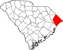 |
| Jasper County | 053 | Ridgeland | 1912 | Beaufort and Hampton | William Jasper, Revolutionary War sergeant | 28,465 | 700 sq mi (1,813 km2) | 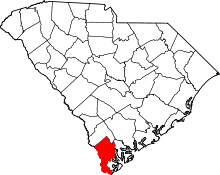 |
| Kershaw County | 055 | Camden | 1798 | Claremont, Fairfield, Lancaster, and Richland | Joseph Kershaw, one of the county's pioneering settlers | 64,097 | 740 sq mi (1,917 km2) | 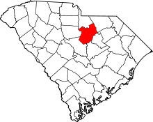 |
| Lancaster County | 057 | Lancaster | 1798 | Camden District | Lancaster County, Pennsylvania | 89,594 | 555 sq mi (1,437 km2) | 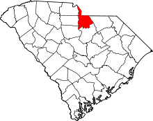 |
| Laurens County | 059 | Laurens | 1785 | Ninety-Six District | Henry Laurens, president of the Second Continental Congress and prisoner of war during the American Revolution | 66,777 | 724 sq mi (1,875 km2) | 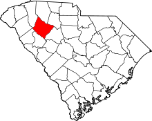 |
| Lee County | 061 | Bishopville | 1902 | Darlington, Kershaw, and Sumter | Robert E. Lee, Confederate general during the Civil War | 17,635 | 411 sq mi (1,064 km2) | 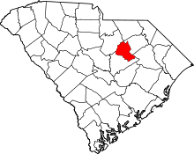 |
| Lexington County | 063 | Lexington | 1804 | Orangeburg | Battle of Lexington, opening skirmish of the Revolutionary War | 286,196 | 758 sq mi (1,963 km2) | 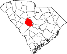 |
| Marion County | 067 | Marion | 1800 | Georgetown | Francis Marion, Revolutionary War general | 31,726 | 494 sq mi (1,279 km2) | 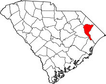 |
| Marlboro County | 069 | Bennettsville | 1785 | Cheraws District | John Churchill, 1st Duke of Marlborough, English general, diplomat, and confidant of monarchs | 26,945 | 485 sq mi (1,256 km2) | 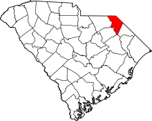 |
| McCormick County | 065 | McCormick | 1914 | Abbeville, Edgefield, and Greenwood | Cyrus McCormick, inventor of the mechanical reaper and founder of International Harvester | 9,643 | 394 sq mi (1,020 km2) | 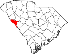 |
| Newberry County | 071 | Newberry | 1785 | Ninety-Six District | Disputed; possibly Newbury, Berkshire, England, or from early settlers' notion that the landscape was as "pretty as a new berry" | 38,079 | 647 sq mi (1,676 km2) | 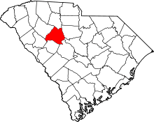 |
| Oconee County | 073 | Walhalla | 1868 | Pickens | Oconee Native Americans | 76,355 | 674 sq mi (1,746 km2) | 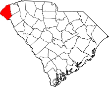 |
| Orangeburg County | 075 | Orangeburg | 1769 | 1769 Judicial District | Prince William V of Orange | 87,903 | 1,128 sq mi (2,922 km2) |  |
| Pickens County | 077 | Pickens | 1826 | Pendleton District | Andrew Pickens, Governor of South Carolina | 122,863 | 512 sq mi (1,326 km2) | 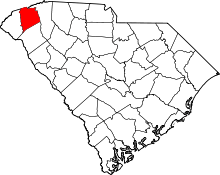 |
| Richland County | 079 | Columbia | 1799 | Camden District | The county's rich soil | 409,549 | 772 sq mi (1,999 km2) | 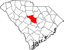 |
| Saluda County | 081 | Saluda | 1896 | Edgefield | Saluda River | 20,197 | 462 sq mi (1,197 km2) | 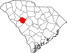 |
| Spartanburg County | 083 | Spartanburg | 1785 | Ninety-Six District | "Spartan Regiment" of the state militia, which was the key force for victory in the Revolutionary War Battle of Cowpens | 301,463 | 819 sq mi (2,121 km2) | 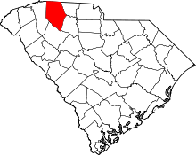 |
| Sumter County | 085 | Sumter | 1798 | Claremont, Clarendon, and Salem | Thomas Sumter, Revolutionary War general and U.S. Senator from South Carolina | 107,396 | 682 sq mi (1,766 km2) | 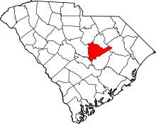 |
| Union County | 087 | Union | 1798 | Ninety-Six District | Union Church, the first Christian place of worship in the area | 27,673 | 516 sq mi (1,336 km2) | 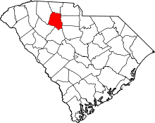 |
| Williamsburg County | 089 | Kingstree | 1802 | Georgetown District | King William III of England | 31,955 | 937 sq mi (2,427 km2) | 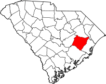 |
| York County | 091 | York | 1798 | Camden District | York County, Pennsylvania | 258,526 | 696 sq mi (1,803 km2) | 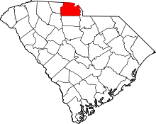 |
Defunct parishes, counties and districts
Parishes
Until the late 19th century, the South Carolina Lowcountry was divided into parishes which in turn were subdivided several "districts"; these civil parishes were based on and generally coincident (even well after disestablishment) with Anglican ecclesiastical parishes.[6]
- St. Helena's Parish (Beaufort District)
- St. Luke's Parish (Beaufort District) created on 23 May 1767, located on Hilton Head Island and the adjacent mainland
- St. Peter's Parish (Beaufort District)
- Prince William Parish (Beaufort District)
- St. Andrew's Parish (Charleston District)
- St. Bartholomew's Parish (Charleston District)
- St. John's Colleton Parish (Charleston District)
- St. George's Dorchester Parish (Charleston District)
- St. Philip's & St. Michael's Parish (Charleston District)
- Christchurch Parish (Charleston District)
- St. James' Goose Creek Parish (Charleston District)
- St. Thomas' & St. Denis' Parish (Charleston District)
- St. John's Berkeley Parish (Charleston District)
- St. Stephen's Parish (Charleston District)
- St. James' Santee Parish (Charleston District)
- St. Paul's Parish (Charleston District)
- All Saints' Parish (Georgetown District)
- Prince George, Winyah, Parish (Georgetown District)
- Prince Frederick Parish (Georgetown District)
- St. David's Parish (Cheraw District)
- St. Mark's Parish (Cheraw District)
- St. Matthew's Parish (Orangeburgh District)
Counties
- Carteret County
- Craven County
- Granville County
- Orange County
- Lewisburg County 1785-1791
- Winton County present-day Barnwell County
- Liberty County present-day Marion County
- Winyah County former name of Georgetown County
- Claremont County
- Salem County
Districts
- Cheraw District created in 1769
- Camden District created in 1769
- Ninety-Six District created in 1769
- Pinckney District 1791-1798
- Washington District 1785-1798
- Pendleton District created in 1789 from Cherokee lands
Proposed counties
- Birch County proposed in 2013 (portions of Lexington and Richland counties)
Notes
- ↑ Section 3, Article VIII of the South Carolina Constitution Archived 4 January 2012 at the Wayback Machine.
- ↑ Edgar, Walter, ed. The South Carolina Encyclopedia, University of South Carolina Press, 2006, pp. 230-234, ISBN 1-57003-598-9
- ↑ South Carolina Department of Archives and History maps.
- ↑ "EPA County FIPS Code Listing". EPA. Retrieved 2007-04-09.
- 1 2 National Association of Counties. "NACo - Find a county". Archived from the original on 25 October 2007. Retrieved 26 April 2007.
- ↑ The Newberry Library (2009). "South Carolina: Individual County Chronologies, South Carolina Atlas of Historical County Boundaries". publications.newberry.org. Chicago, Illinois, US. Retrieved June 5, 2018.
References
- Landrum, John Belton O'Neall (1897) Colonial and revolutionary history of upper South Carolina: embracing for the most part the primitive and colonial history of the territory comprising the original county of Spartanburg with a general review of the entire military operations in the upper portion of South Carolina and portions of North Carolina Shannon and Company, Greenville, South Carolina, OCLC 3492548
External links
- Information on County Formation timeline
- Complete South Carolina County Guide
- Map of former parishes of South Carolina South Carolina Department of Archives and History