Mercer County, Illinois
| Mercer County, Illinois | |
|---|---|
 | |
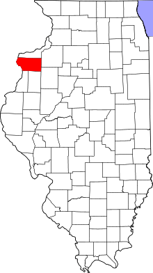 Location in the U.S. state of Illinois | |
 Illinois's location in the U.S. | |
| Founded | January 13, 1825 |
| Named for | Hugh Mercer |
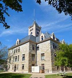
| Seat | Aledo |
| Largest city | Aledo |
| Area | |
| • Total | 569 sq mi (1,474 km2) |
| • Land | 561 sq mi (1,453 km2) |
| • Water | 7.5 sq mi (19 km2), 1.3% |
| Population | |
| • (2010) | 16,434 |
| • Density | 29/sq mi (11/km2) |
| Congressional district | 17th |
| Time zone | Central: UTC−6/−5 |
| Website |
www |
Mercer County is a county located in the U.S. state of Illinois. According to the 2010 census, it had a population of 16,434.[1] Its county seat is Aledo.[2]
Mercer County is included in the Davenport-Moline-Rock Island, IA-IL Metropolitan Statistical Area.[3]
History
Mercer County is named for Hugh Mercer (1726–1777), a physician and general during the American Revolution who died from wounds suffered at the Battle of Princeton.
In May 1812, Congress passed an act which set aside lands in Arkansas, Michigan, and Illinois as payment to volunteer soldiers in the War of 1812. Mercer County was part of this "Military Tract."
Seven years after Illinois became a state, Mercer County was founded. It was formed from unorganized territory near Pike County on January 13, 1825. Although the county had been created, its government was not organized for several years; for administration purposes it was attached first to Schuyler County (until 1826), then to Peoria (until 1831), and finally to Warren County. The organization of the county government was finally completed in 1835, after a large influx of settlers following the Black Hawk War.[4]
 Mercer County at the time of its creation in 1825
 Mercer County in 1827, reduced to its present borders
Geography
According to the U.S. Census Bureau, the county has a total area of 569 square miles (1,470 km2), of which 561 square miles (1,450 km2) is land and 7.5 square miles (19 km2) (1.3%) is water.[5]
Climate and weather
| Aledo, Illinois | ||||||||||||||||||||||||||||||||||||||||||||||||||||||||||||
|---|---|---|---|---|---|---|---|---|---|---|---|---|---|---|---|---|---|---|---|---|---|---|---|---|---|---|---|---|---|---|---|---|---|---|---|---|---|---|---|---|---|---|---|---|---|---|---|---|---|---|---|---|---|---|---|---|---|---|---|---|
| Climate chart (explanation) | ||||||||||||||||||||||||||||||||||||||||||||||||||||||||||||
| ||||||||||||||||||||||||||||||||||||||||||||||||||||||||||||
| ||||||||||||||||||||||||||||||||||||||||||||||||||||||||||||
In recent years, average temperatures in the county seat of Aledo have ranged from a low of 11 °F (−12 °C) in January to a high of 84 °F (29 °C) in July, although a record low of −30 °F (−34 °C) was recorded in February 1905 and a record high of 113 °F (45 °C) was recorded in July 1936. Average monthly precipitation ranged from 1.27 inches (32 mm) in January to 4.43 inches (113 mm) in June.[6]
Major highways
Adjacent counties
- Rock Island County - north
- Henry County - east
- Knox County - southeast
- Henderson County - south
- Warren County - south
- Des Moines County, Iowa - southwest
- Louisa County, Iowa - west
Demographics
| Historical population | |||
|---|---|---|---|
| Census | Pop. | %± | |
| 1830 | 26 | — | |
| 1840 | 2,352 | 8,946.2% | |
| 1850 | 5,246 | 123.0% | |
| 1860 | 15,042 | 186.7% | |
| 1870 | 18,769 | 24.8% | |
| 1880 | 19,502 | 3.9% | |
| 1890 | 18,545 | −4.9% | |
| 1900 | 20,945 | 12.9% | |
| 1910 | 19,723 | −5.8% | |
| 1920 | 18,800 | −4.7% | |
| 1930 | 16,641 | −11.5% | |
| 1940 | 17,701 | 6.4% | |
| 1950 | 17,374 | −1.8% | |
| 1960 | 17,149 | −1.3% | |
| 1970 | 17,294 | 0.8% | |
| 1980 | 19,286 | 11.5% | |
| 1990 | 17,290 | −10.3% | |
| 2000 | 16,957 | −1.9% | |
| 2010 | 16,434 | −3.1% | |
| Est. 2016 | 15,730 | [7] | −4.3% |
| U.S. Decennial Census[8] 1790-1960[9] 1900-1990[10] 1990-2000[11] 2010-2013[1] | |||
As of the 2010 United States Census, there were 16,434 people, 6,734 households, and 4,724 families residing in the county.[12] The population density was 29.3 inhabitants per square mile (11.3/km2). There were 7,358 housing units at an average density of 13.1 per square mile (5.1/km2).[5] The racial makeup of the county was 98.3% white, 0.3% black or African American, 0.3% Asian, 0.1% American Indian, 0.3% from other races, and 0.7% from two or more races. Those of Hispanic or Latino origin made up 1.9% of the population.[12] In terms of ancestry, 25.9% were German, 18.2% were Irish, 11.3% were English, 9.4% were Swedish, and 7.4% were American.[13]
Of the 6,734 households, 30.1% had children under the age of 18 living with them, 58.3% were married couples living together, 7.9% had a female householder with no husband present, 29.8% were non-families, and 25.8% of all households were made up of individuals. The average household size was 2.41 and the average family size was 2.88. The median age was 43.7 years.[12]
The median income for a household in the county was $50,909 and the median income for a family was $62,025. Males had a median income of $46,136 versus $30,392 for females. The per capita income for the county was $25,332. About 8.2% of families and 9.3% of the population were below the poverty line, including 14.9% of those under age 18 and 7.2% of those age 65 or over.[14]
Communities
Cities
Villages
Unincorporated communities
Townships
Mercer County is divided into fifteen townships:
Politics
| Year | Republican | Democratic | Third Parties |
|---|---|---|---|
| 2016 | 56.4% 4,807 | 36.0% 3,071 | 7.6% 647 |
| 2012 | 45.2% 3,876 | 52.6% 4,507 | 2.2% 185 |
| 2008 | 43.2% 3,833 | 55.1% 4,887 | 1.7% 150 |
| 2004 | 49.1% 4,405 | 50.3% 4,512 | 0.6% 57 |
| 2000 | 44.3% 3,688 | 52.9% 4,400 | 2.8% 230 |
| 1996 | 34.0% 2,688 | 54.2% 4,278 | 11.8% 931 |
| 1992 | 34.9% 2,983 | 46.7% 3,990 | 18.3% 1,567 |
| 1988 | 46.5% 3,683 | 53.0% 4,204 | 0.5% 42 |
| 1984 | 55.0% 4,907 | 44.6% 3,982 | 0.4% 38 |
| 1980 | 56.2% 5,144 | 36.7% 3,361 | 7.1% 651 |
| 1976 | 53.6% 4,816 | 45.5% 4,090 | 0.9% 76 |
| 1972 | 61.0% 5,452 | 38.9% 3,477 | 0.1% 11 |
| 1968 | 56.3% 4,844 | 36.6% 3,143 | 7.1% 613 |
| 1964 | 48.9% 4,220 | 51.1% 4,410 | |
| 1960 | 61.6% 5,582 | 38.4% 3,476 | 0.0% 3 |
| 1956 | 65.8% 5,732 | 34.1% 2,969 | 0.1% 7 |
| 1952 | 70.5% 6,416 | 29.5% 2,679 | 0.0% 2 |
| 1948 | 62.6% 5,267 | 37.0% 3,117 | 0.4% 36 |
| 1944 | 63.1% 5,667 | 36.5% 3,277 | 0.4% 34 |
| 1940 | 62.1% 6,336 | 37.5% 3,830 | 0.4% 38 |
| 1936 | 50.9% 5,028 | 48.1% 4,751 | 1.1% 105 |
| 1932 | 50.2% 4,436 | 48.8% 4,309 | 1.0% 90 |
| 1928 | 70.6% 5,699 | 28.7% 2,316 | 0.7% 58 |
| 1924 | 68.3% 5,618 | 20.7% 1,699 | 11.0% 908 |
| 1920 | 74.6% 5,531 | 21.2% 1,574 | 4.2% 311 |
| 1916 | 58.9% 5,308 | 38.1% 3,430 | 3.0% 270 |
| 1912 | 19.2% 959 | 32.1% 1,602 | 48.7% 2,435 |
| 1908 | 57.5% 2,871 | 35.6% 1,777 | 6.9% 344 |
| 1904 | 63.7% 3,230 | 27.3% 1,386 | 9.1% 459 |
| 1900 | 59.4% 3,304 | 37.9% 2,110 | 2.7% 149 |
| 1896 | 56.5% 3,120 | 42.2% 2,329 | 1.4% 75 |
| 1892 | 52.7% 2,470 | 42.1% 1,975 | 5.2% 242 |
Historically Mercer County was a solidly Republican Yankee-influenced county, and before the Republican Party existed a stronghold of the Whig Party. The county never voted for a Democratic presidential candidate until Lyndon Johnson’s 1964 landslide over Barry Goldwater – the solitary break in Whig and Republican dominance occurring in 1912 when the GOP was mortally split and Progressive Theodore Roosevelt carried the county over conservative incumbent President William Howard Taft. After Johnson’s victory in the county, Mercer voted to being Republican between 1968 and 1984, but Reagan’s landslide in that election saw a swing to the Democrats that was capitalized upon by Michael Dukakis to carry the county in 1988. Between than and 2012, Mercer was solidly Democratic, but concern over declining economic opportunities in the “Rust Belt” caused a dramatic swing to populist Republican Donald Trump in 2016. Trump’s performance was the best by a Republican since Richard Nixon’s 3,000-plus-county landslide in 1972.
Mercer County is located in Illinois's 17th Congressional District and is currently represented by Democrat Cheri Bustos. Within the Illinois House of Representatives, the county is located in the 74th district and is currently represented by Republican Daniel Swanson. The county is located in the 37th district of the Illinois Senate, and is currently represented by Republican Chuck Weaver.
See also
Footnotes
- 1 2 "State & County QuickFacts". United States Census Bureau. Archived from the original on July 14, 2011. Retrieved July 7, 2014.
- ↑ "Find a County". National Association of Counties. Retrieved 2011-06-07.
- ↑ United States Office of Management and Budget. "Update of Statistical Area Definitions and Guidance on Their Uses" (PDF). pp. 5, 36. Archived from the original (PDF) on 2006-05-14. Retrieved 2006-07-21.
- ↑ Mercer County Fact Sheet, Illinois State Archives. "Archived copy". Archived from the original on 2007-10-23. Retrieved 2007-10-23.
- 1 2 "Population, Housing Units, Area, and Density: 2010 - County". United States Census Bureau. Retrieved 2015-07-12.
- 1 2 "Monthly Averages for Aledo, Illinois". The Weather Channel. Retrieved 2011-01-27.
- ↑ "Population and Housing Unit Estimates". Retrieved June 9, 2017.
- ↑ "U.S. Decennial Census". United States Census Bureau. Retrieved July 7, 2014.
- ↑ "Historical Census Browser". University of Virginia Library. Retrieved July 7, 2014.
- ↑ "Population of Counties by Decennial Census: 1900 to 1990". United States Census Bureau. Retrieved July 7, 2014.
- ↑ "Census 2000 PHC-T-4. Ranking Tables for Counties: 1990 and 2000" (PDF). United States Census Bureau. Retrieved July 7, 2014.
- 1 2 3 "DP-1 Profile of General Population and Housing Characteristics: 2010 Demographic Profile Data". United States Census Bureau. Retrieved 2015-07-12.
- ↑ "DP02 SELECTED SOCIAL CHARACTERISTICS IN THE UNITED STATES – 2006-2010 American Community Survey 5-Year Estimates". United States Census Bureau. Retrieved 2015-07-12.
- ↑ "DP03 SELECTED ECONOMIC CHARACTERISTICS – 2006-2010 American Community Survey 5-Year Estimates". United States Census Bureau. Retrieved 2015-07-12.
- ↑ http://uselectionatlas.org/RESULTS
Further reading
- William C. Ives, "Abraham Lincoln in Mercer County, Illinois, 1832, 1834, 1858," Journal of the Illinois State Historical Society, vol. 101 (Fall–Winter 2008), pp. 329–347.
- History of Mercer and Henderson Counties, Together with Biographical Matter, Statistics, Etc. Chicago: H.H. Hill and Company, 1882.
External links
Places adjacent to Mercer County, Illinois | ||||||||||
|---|---|---|---|---|---|---|---|---|---|---|
| ||||||||||
Municipalities and communities of Mercer County, Illinois, United States | ||
|---|---|---|
| Cities | ||
| Villages | ||
| Townships | ||
| Unincorporated communities | ||
| Footnotes | ‡This populated place also has portions in an adjacent county or counties | |
