List of counties in Washington
| Counties of Washington | |
|---|---|
| Location | State of Washington |
| Number | 39 |
| Populations | 2,266 (Garfield) – 1,931,249 (King) |
| Areas | 175 square miles (450 km2) (San Juan) – 2,742 square miles (7,100 km2) (Okanogan) |
| Government | County government |
| Subdivisions | cities, towns, townships, unincorporated communities, Native reservations, census designated place |
There are 39 counties in the U.S. state of Washington. Washington came from what was the western part of Washington Territory and was admitted to the Union as the 42nd state in 1889.[1] The first counties were created from unorganized territory in 1845.[2] Eight of the counties were created by Oregon governments prior to the organization of Washington Territory, 26 were created during Washington's territorial period, and five more were created after Washington became a state (Benton, Chelan, Grant, Ferry, and Pend Oreille).[3]
Article XI of the Washington State Constitution addresses the organization of counties. New counties must have a population of at least 2,000 and no county can be reduced to a population below 4,000 due to partitioning to create a new county.[4] At least one early county, named Quillehuyte, was disestablished by the territorial government due to low population.[5] To alter the area of a county, the state constitution requires a petition of the "majority of the voters" in that area. A number of county partition proposals in the 1990s interpreted this as a majority of people who voted, until a 1998 ruling by the Washington Supreme Court clarified that they would need a majority of registered voters.[6]
The Federal Information Processing Standard (FIPS) code, used by the United States government to uniquely identify counties, is provided with each entry. The FIPS code links in the table point to U. S. Census "quick facts" pages for each county.
Washington's postal abbreviation is WA and its FIPS state code is 53.
List
| County |
FIPS code[7] | County seat[8] | Established[8] | Origin[2] | Etymology[2] | Population[8] | Area[8] | Map |
|---|---|---|---|---|---|---|---|---|
| Adams County | 001 | Ritzville | 1883 | Whitman County | John Adams (1735–1826), 2nd U.S. President, John Quincy Adams (1767-1848), 6th U.S. President | 18,728 | 1,925 sq mi (4,986 km2) | 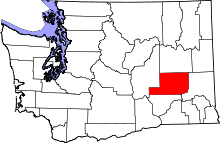 |
| Asotin County | 003 | Asotin | 1883 | Garfield County | The Nez Percé name for Eel Creek | 21,623 | 636 sq mi (1,647 km2) | 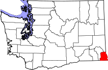 |
| Benton County | 005 | Prosser | 1905 | Yakima and Klickitat Counties | Thomas Hart Benton (1782–1858), a Missouri U.S. Senator | 175,177 | 1,703 sq mi (4,411 km2) | 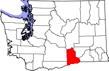 |
| Chelan County | 007 | Wenatchee | 1899 | Okanogan and Kittitas Counties | A Native American word meaning "deep water", likely referring to Lake Chelan | 72,453 | 2,922 sq mi (7,568 km2) | 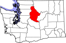 |
| Clallam County | 009 | Port Angeles | 1854 | Jefferson County | A Klallam word meaning "the strong people" | 71,404 | 1,745 sq mi (4,520 km2) | 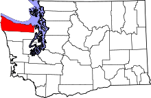 |
| Clark County | 011 | Vancouver | 1845 | Original county | William Clark (1770–1838), the co-captain of the Lewis and Clark Expedition | 425,363 | 628 sq mi (1,627 km2) | 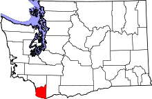 |
| Columbia County | 013 | Dayton | 1875 | Walla Walla County | The Columbia River | 4,078 | 869 sq mi (2,251 km2) | 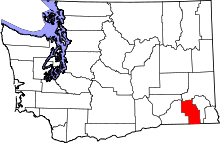 |
| Cowlitz County | 015 | Kelso | 1854 | Original county | Cowlitz, an Indian tribe | 102,410 | 1,139 sq mi (2,950 km2) | 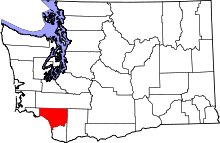 |
| Douglas County | 017 | Waterville | 1883 | Lincoln County | Stephen A. Douglas (1813–1861), U.S. Senator from Illinois | 38,431 | 1,821 sq mi (4,716 km2) | 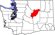 |
| Ferry County | 019 | Republic | 1899 | Stevens County | Elisha P. Ferry (1825–1895), 1st Governor of Washington State | 7,551 | 2,204 sq mi (5,708 km2) | 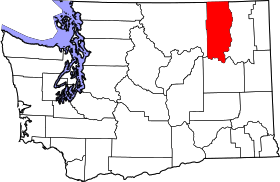 |
| Franklin County | 021 | Pasco | 1883 | Whitman County | Benjamin Franklin (1706–1790), writer, orator, inventor, and U.S. Founding Father | 78,163 | 1,242 sq mi (3,217 km2) | 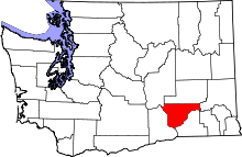 |
| Garfield County | 023 | Pomeroy | 1881 | Columbia County | James A. Garfield (1831–1881), 20th U.S. President | 2,266 | 710 sq mi (1,839 km2) | 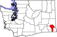 |
| Grant County | 025 | Ephrata | 1909 | Douglas County | Ulysses S. Grant (1822–1885), 18th U.S. President | 89,120 | 2,681 sq mi (6,944 km2) | 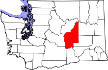 |
| Grays Harbor County | 027 | Montesano | 1854 | Thurston County | Grays Harbor, a body of water named after explorer and merchant Robert Gray (1755–1806) | 72,797 | 1,917 sq mi (4,965 km2) | 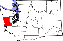 |
| Island County | 029 | Coupeville | 1853 | Thurston County | Whidbey and Camano Islands | 78,506 | 209 sq mi (541 km2) | 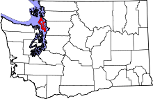 |
| Jefferson County | 031 | Port Townsend | 1852 | Thurston County | Thomas Jefferson (1743–1826), 3rd U.S. President and principal author of the Declaration of Independence | 29,872 | 1,809 sq mi (4,685 km2) | 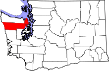 |
| King County | 033 | Seattle | 1852 | Thurston County | William R. King (1786–1853), U.S. Vice President under Franklin Pierce; officially renamed in 1986 after Martin Luther King, Jr. (1929–1968) | 1,931,249 | 2,126 sq mi (5,506 km2) | 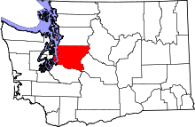 |
| Kitsap County | 035 | Port Orchard | 1857 | King and Jefferson Counties | Chief Kitsap (d. 1860), leader of the Suquamish tribe | 251,133 | 396 sq mi (1,026 km2) | 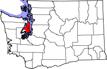 |
| Kittitas County | 037 | Ellensburg | 1883 | Yakima County | Kittitas tribe word of uncertain meaning, with popular translations ranging from "white chalk" to "land of the plenty" | 40,915 | 2,297 sq mi (5,949 km2) | 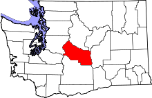 |
| Klickitat County | 039 | Goldendale | 1859 | Walla Walla County | Klickitat Tribe | 20,318 | 1,872 sq mi (4,848 km2) | 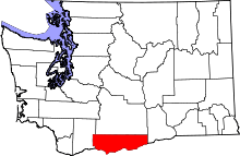 |
| Lewis County | 041 | Chehalis | 1845 | Original county | Meriwether Lewis (1774–1809), the co-captain of the Lewis and Clark Expedition | 75,455 | 2,408 sq mi (6,237 km2) | 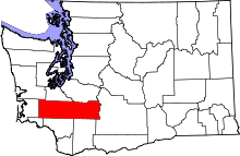 |
| Lincoln County | 043 | Davenport | 1883 | Whitman County | Abraham Lincoln (1809–1865), 16th U.S. President | 10,570 | 2,311 sq mi (5,985 km2) | 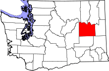 |
| Mason County | 045 | Shelton | 1854 | King County | Charles H. Mason (1830–1859), 1st Secretary of Washington Territory | 60,699 | 961 sq mi (2,489 km2) | 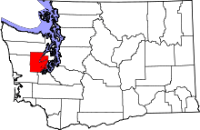 |
| Okanogan County | 047 | Okanogan | 1888 | Stevens County | A Salish Native American word meaning "rendezvous" | 41,120 | 5,268 sq mi (13,644 km2) | 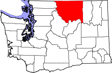 |
| Pacific County | 049 | South Bend | 1851 | Lewis County | The Pacific Ocean | 20,920 | 975 sq mi (2,525 km2) | 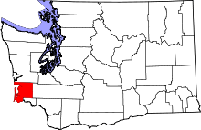 |
| Pend Oreille County | 051 | Newport | 1911 | Stevens County | The Pend d'Oreille Native American tribe | 13,001 | 1,400 sq mi (3,626 km2) | 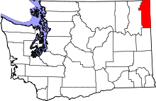 |
| Pierce County | 053 | Tacoma | 1852 | Thurston County | Franklin Pierce (1804–1869), 14th U.S. President | 795,225 | 1,676 sq mi (4,341 km2) | 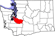 |
| San Juan County | 055 | Friday Harbor | 1873 | Whatcom County | San Juan Island | 15,769 | 175 sq mi (453 km2) | 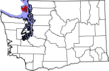 |
| Skagit County | 057 | Mount Vernon | 1883 | Whatcom County | The Skagit Native American tribe | 116,901 | 1,735 sq mi (4,494 km2) | 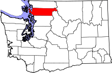 |
| Skamania County | 059 | Stevenson | 1854 | Clark County | A Chinookan word meaning "swift water" | 11,066 | 1,656 sq mi (4,289 km2) |  |
| Snohomish County | 061 | Everett | 1861 | Island County | The Snohomish tribe | 713,335 | 2,090 sq mi (5,413 km2) | 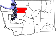 |
| Spokane County | 063 | Spokane | 1879 a | Stevens County | The Spokane Native American tribe | 471,221 | 1,764 sq mi (4,569 km2) | 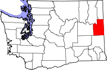 |
| Stevens County | 065 | Colville | 1863 | Walla Walla County | Isaac Stevens (1818–1862), 1st Governor of the Washington Territory | 43,531 | 2,478 sq mi (6,418 km2) | 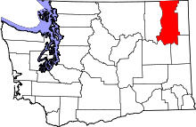 |
| Thurston County | 067 | Olympia | 1852 | Lewis County | Samuel Thurston (1815–1851), the Oregon Territory's first delegate to U.S. Congress | 252,264 | 727 sq mi (1,883 km2) | 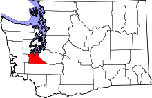 |
| Wahkiakum County | 069 | Cathlamet | 1854 | Cowlitz County | Leader of Wahkiakum ("Tall Timber"), Native American tribe | 3,978 | 264 sq mi (684 km2) | 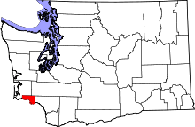 |
| Walla Walla County | 071 | Walla Walla | 1854 | Skamania County | The Walla Walla Native American tribe, and also another name for running water | 58,781 | 1,270 sq mi (3,289 km2) | 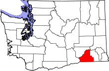 |
| Whatcom County | 073 | Bellingham | 1854 | Island County | Nooksack word meaning "noisy water" | 201,140 | 2,120 sq mi (5,491 km2) | 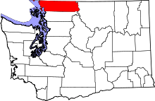 |
| Whitman County | 075 | Colfax | 1871 | Stevens County | Marcus Whitman (1802–1847), a Methodist missionary | 44,776 | 2,159 sq mi (5,592 km2) | 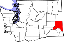 |
| Yakima County | 077 | Yakima | 1865 | Ferguson County (defunct) | The Yakama Native American tribe | 243,231 | 4,296 sq mi (11,127 km2) | 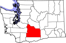 |
Former county names
- Chehalis County, originally named for the Chehalis people, was renamed Grays Harbor County in 1915.[9][10]
- Sawamish County, originally named for the Sahewamish Native American tribe, was renamed Mason County in 1864.[11]
- Slaughter County, originally named for Lieutenant William A. Slaughter who was killed during the Indian Wars, was renamed Kitsap County shortly after its formation in 1857.[12] The initial proposals for this county called it Madison County or Kitsap County.[13]
- Vancouver County, originally named for George Vancouver, was renamed Clark County in 1849.[14][15]
Former counties
- Ferguson County, named for Washington legislator James L. Ferguson, was established on January 23, 1863 from Walla Walla County and dissolved on January 18, 1865. Yakima County was established in its place.[16][17]
- Quillehuyte County was split from Jefferson and Clallam counties in 1868 and returned to those counties a year later.[5]
Proposed counties
- The representatives at the Cowlitz Convention of 1851 discussed a proposal to form Columbia Territory, which included a number of new counties in what later became Washington. The next session of the Oregon Territorial Legislature created only one of counties: Thurston County (which was originally proposed as Simmons County).[18][19]
- Buchanan County was proposed in 1856 as a division of Clark County.[20]
- Other proposed counties during Washington's statehood have included (with proposal dates): Big Bend (1891), Palouse (1891 and 1903), Sherman (1891), Washington (1891), McKinley (1903), Steptoe (1903), Coulee (1905).[21]
Notes
References
- ↑ "Historical Timeline of Events Leading to the formation of Washington State". Archived from the original on 2012-07-10. Retrieved 2008-08-09.
- 1 2 3 "Washington Counties". Online Encyclopedia of Washington State History. HistoryLink.org. Archived from the original on 2008-03-28. Retrieved 2008-05-06.
- ↑ Smith 1913, p. 1 (As noted on p. 15, Pend Oreille County was not included in this tally because it was organized after the article was first published in 1909.)
- ↑ Article XI, Section 3 ("New Counties") of the Washington State Constitution
- 1 2 Smith 1913, p. 11
- ↑ Hal Spencer (February 6, 1998). "New counties dealt major blow". The Spokesman-Review. AP. p. B8.
"Cedar County Committee v. Munro (No. 64958-8)". FindLaw. February 5, 1998. - ↑ "EPA County FIPS Code Listing". US Environmental Protection Agency. Retrieved 2008-05-06.
- 1 2 3 4 National Association of Counties. "NACo - Find A County". Retrieved 2011-03-04.
- ↑ Ott, Jen (July 1, 2008). "Chehalis -- Thumbnail History". HistoryLink.org. Retrieved 2012-09-26.
- ↑ "Chapter 77 (S.B. 297), Changing Name of Chehalis County". Session Laws of the State of Washington. 1915. p. 250.
- ↑ Wilma, David (April 19, 2006). "Washington Territorial Legislature creates Sawamish (Mason) County on April 15, 1854". HistoryLink.org. Retrieved 2012-03-05.
- ↑ Wilma, David (July 27, 2006). "Slaughter County is renamed Kitsap County on July 13, 1857". HistoryLink.org. Retrieved 2012-03-16.
- ↑ Smith 1913, pp. 7–8
- ↑ Smith 1913, pp. 1–2
- ↑ Holman 1910, pp. 3–5
- ↑ Becker, Paula (September 20, 2005). "Ferguson County is established on January 23, 1863". HistoryLink.org. Retrieved 2012-03-05.
- ↑ "Milestones for Washington State History -- Part 2: 1851 to 1900". HistoryLink.org. March 6, 2003. Retrieved 2012-03-05.
- ↑ Smith 1913, pp. 3–4
- ↑ Meany 1922, pp. 11–12
- ↑ Smith 1913, p. 7
- ↑ Smith 1913, pp. 13–14
- ↑ Smith 1913, p. 9
Works
- Holman, Frederick V. (March 1910). "History of the Counties of Oregon". Oregon Historical Quarterly. Portland, Oregon: Ivy Press. XI (1).
- Meany, Edmond S. (January 1922). "The Cowlitz Convention: Inception of Washington Territory". The Washington Historical Quarterly. Seattle, Washington: University of Washington. XIII (1).
- Smith, Charles W. (October 1913) [1909], The Naming of Counties in the State of Washington, Seattle, Washington: University of Washington
External links
- Washington State and County Maps and Atlases, includes a step-by-step map showing the evolution of the counties
