List of counties in Indiana
| Counties of Indiana | |
|---|---|
 | |
| Location | State of Indiana |
| Number | 92 |
| Populations | 6,128 (Ohio) – 903,393 (Marion) |
| Areas | 86 square miles (220 km2) (Ohio) – 657 square miles (1,700 km2) (Allen) |
| Government | County government |
| Subdivisions | 1,008 Townships |
The U.S. state of Indiana has 92 counties. Each county serves as the local level of government within its borders. Although Indiana was organized into the United States since the Northwest Ordinance in 1787, its land was not always available for settlement. Eventually, land was purchased from Native Americans by treaties and Indian removals. The oldest counties are generally in the south near the Ohio River, whereas newer ones were in the north in territory acquired later. The oldest and newest counties in Indiana are Knox County, created in 1790, and Newton County, created in 1859.
As of the 2010 United States Census, the population of Indiana was 6,483,802, the average population of Indiana's 92 counties is 70,476, with Marion County as the most populous (903,393), and Ohio County (6,128) the least. 54 counties have 30,000 or more people; 17 counties have populations exceeding 100,000, five of which exceed 250,000; and only four counties have fewer than 10,000 people. The average land area is 396 square miles (1,030 km2).[1] The largest county is Allen (657 sq. mi., 1,702 km²) and the smallest is Ohio (86 sq. mi., 223 km²).[2] According to the Constitution of Indiana, no county may be created of less than 400 square miles (1,000 km2), nor may any county smaller than this be further reduced in size.[3]
County government in Indiana consists of two bodies, the county council and the commissioners.
Many Indiana counties are named for United States Founding Fathers and personalities of the American Revolutionary War, the War of 1812 and Battle of Tippecanoe; early leaders of Indiana Territory and Indiana, as well as surrounding states like Michigan and Kentucky; plus Native American tribes and geographical features.
The Federal Information Processing Standard (FIPS) code, which is used by the United States government to uniquely identify states and counties, is provided with each entry. Indiana's code is 18, which when combined with any county code would be written as 18XXX. The FIPS code for each county links to census data for that county.[4]
In Indiana, the most commonly seen number associated with counties is the state county code, which is a sequential number based on the alphabetical order of the county. It has been used on automobile license plates since 1963. It first held a prominent place on the left side of the plates as part of the license plate number until the year 2008 when it was moved above the serial number and 2012 when it was moved to the lower right corner. On license plates, county codes 93, 95, and 97-99 were also used for Marion County in addition to 49. 94 and 96 were used for Lake County in addition to 45.[5]
List of counties
| County |
FIPS code[6] | County seat[2][7] | Established[2][7] | Origin | Etymology[8] | BMV Number [9] |
Population[1] | Area(Land only) [2][10] | Map |
|---|---|---|---|---|---|---|---|---|---|
| Adams County | 001 | Decatur | February 7, 1836 | Adams New Purchase | U.S. President John Quincy Adams | 1 | 34,387 | 339 sq mi (878 km2) | 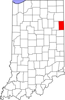 |
| Allen County | 003 | Fort Wayne | December 12, 1823 | Delaware New Purchase | Col. John Allen, Kentucky state senator[11] | 2 | 355,329 | 657 sq mi (1,702 km2) | 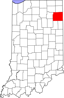 |
| Bartholomew County | 005 | Columbus | January 8, 1821 | Jackson County and Delaware New Purchases | Lt. Col. Joseph Bartholomew, a hero of the Battle of Tippecanoe[11] | 3 | 76,794 | 407 sq mi (1,054 km2) | 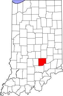 |
| Benton County | 007 | Fowler | February 18, 1840 | Jasper County | Thomas H. Benton, U.S. Senator from Missouri | 4 | 8,854 | 406 sq mi (1,052 km2) | 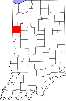 |
| Blackford County | 009 | Hartford City | February 15, 1838 | Jay County | Judge Isaac Blackford, Speaker of the Indiana House of Representatives and Chief Justice of the Indiana Supreme Court | 5 | 12,766 | 165 sq mi (427 km2) | 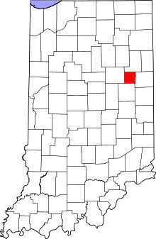 |
| Boone County | 011 | Lebanon | January 29, 1830 | Adams and Wabash New Purchases | Frontiersman Daniel Boone | 6 | 56,640 | 423 sq mi (1,096 km2) | 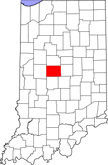 |
| Brown County | 013 | Nashville | February 3, 1836 | Bartholomew County Jackson County Monroe County | General Jacob Brown, hero of the War of 1812[11] | 7 | 15,242 | 312 sq mi (808 km2) | 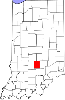 |
| Carroll County | 015 | Delphi | January 17, 1828 | Adams and Wabash New Purchases | Charles Carroll, signer of the Declaration of Independence | 8 | 20,165 | 372 sq mi (963 km2) | 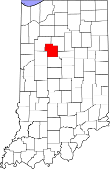 |
| Cass County | 017 | Logansport | December 18, 1828 | Non-county Area | Gen. Lewis Cass, Governor of Michigan Territory and U.S. Secretary of State | 9 | 38,966 | 412 sq mi (1,067 km2) | 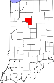 |
| Clark County | 019 | Jeffersonville | February 3, 1801 | Knox County | General George Rogers Clark, American Revolutionary War hero | 10 | 110,232 | 373 sq mi (966 km2) | 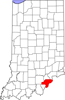 |
| Clay County | 021 | Brazil | February 12, 1825 | Owen County Putnam County Sullivan County Vigo County | U.S. Speaker of the House Henry Clay | 11 | 26,890 | 358 sq mi (927 km2) | 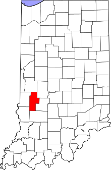 |
| Clinton County | 023 | Frankfort | January 29, 1830 | Adams and Wabash New Purchases | DeWitt Clinton, Governor of New York | 12 | 33,224 | 405 sq mi (1,049 km2) | 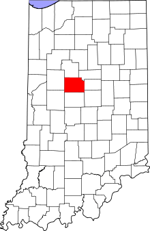 |
| Crawford County | 025 | English | January 29, 1818 | Orange County Harrison County Perry County | Col. William Crawford, surveyor of the Midwest and hero of the Indian Wars | 13 | 10,713 | 306 sq mi (793 km2) | 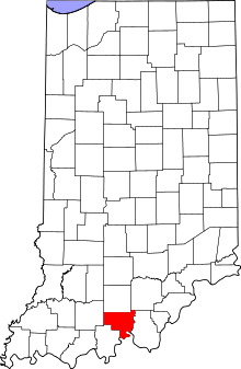 |
| Daviess County | 027 | Washington | February 2, 1818 | Knox County | Col. Joseph Hamilton Daveiss,[11] hero of the Battle of Tippecanoe | 14 | 31,648 | 429 sq mi (1,111 km2) | 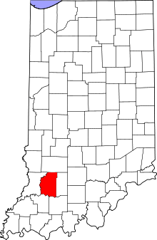 |
| Dearborn County | 029 | Lawrenceburg | March 7, 1803 | Clark County, IN; Hamilton County, OH | U.S. Secretary of War Henry Dearborn | 15 | 50,047 | 305 sq mi (790 km2) | 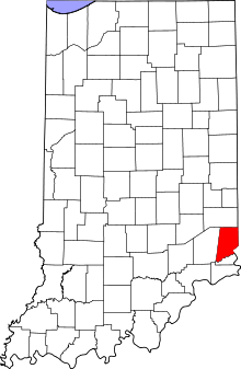 |
| Decatur County | 031 | Greensburg | December 12, 1821 | Delaware New Purchase | Commodore Stephen Decatur, hero of the War of 1812 | 16 | 25,740 | 373 sq mi (966 km2) | 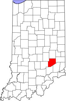 |
| DeKalb County | 033 | Auburn | February 7, 1835 | Non-county Area | Johann de Kalb, German noble who trained colonial soldiers for the American Revolutionary War | 17 | 40,285 | 363 sq mi (940 km2) |  |
| Delaware County | 035 | Muncie | January 26, 1827[12] | Delaware New Purchase | Delaware Native American people | 18 | 117,671 | 392 sq mi (1,015 km2) | 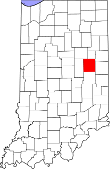 |
| Dubois County | 037 | Jasper | December 20, 1817 | Perry County Pike County | Toussaint Dubois,[11] hero of the Battle of Tippecanoe | 19 | 41,889 | 427 sq mi (1,106 km2) | 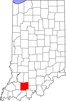 |
| Elkhart County | 039 | Goshen | January 29, 1830 | Non-county Area | Disputed, but possibly the Elkhart Native American people | 20 | 197,559 | 463 sq mi (1,199 km2) | 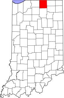 |
| Fayette County | 041 | Connersville | January 29, 1818 | Franklin Wayne County and Non-county Area | Marquis de la Fayette, French noble who trained colonial soldiers in the American Revolutionary War | 21 | 24,277 | 215 sq mi (557 km2) | 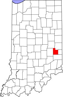 |
| Floyd County | 043 | New Albany | January 2, 1819 | Clark and Harrison Counties | Either John Floyd, a War of 1812 hero and Governor of Virginia, or early settler and state legislator Davis Floyd[11] | 22 | 74,578 | 148 sq mi (383 km2) | 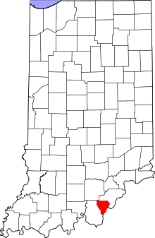 |
| Fountain County | 045 | Covington | December 20, 1825 | Montgomery County and Wabash New Purchase | Major James Fontaine, a hero of the American Revolutionary War | 23 | 17,240 | 396 sq mi (1,026 km2) | 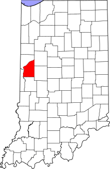 |
| Franklin County | 047 | Brookville | February 1, 1811 | Clark County Dearborn County Knox County | Writer, orator, scholar, and founding father Benjamin Franklin | 24 | 23,087 | 384 sq mi (995 km2) | 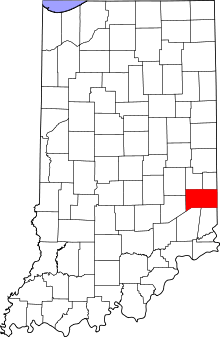 |
| Fulton County | 049 | Rochester | February 7, 1836 | Non-county Area | Robert Fulton, developer of the steamboat | 25 | 20,836 | 368 sq mi (953 km2) | 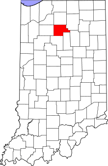 |
| Gibson County | 051 | Princeton | April 1, 1813 | Knox County | John Gibson, secretary of the Indiana Territory[11] | 26 | 33,503 | 487 sq mi (1,261 km2) | 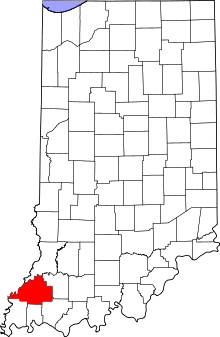 |
| Grant County | 053 | Marion | February 10, 1831 | Formed from Madison County, Adams New Purchase and un-organized | Captains Samuel and Moses Grant, former American soldiers and early settlers | 27 | 70,061 | 414 sq mi (1,072 km2) | 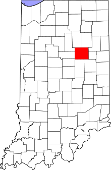 |
| Greene County | 055 | Bloomfield | January 5, 1821 | Sullivan County Non-county Area | Gen. Nathanael Greene, hero of the American Revolutionary War | 28 | 33,165 | 543 sq mi (1,406 km2) | 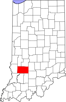 |
| Hamilton County | 057 | Noblesville | January 8, 1823 | Formed from Delaware New Purchase | Alexander Hamilton, first Secretary of the Treasury and founding father | 29 | 274,569 | 394 sq mi (1,020 km2) | 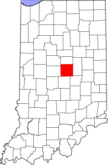 |
| Hancock County | 059 | Greenfield | March 1, 1828 | Formed from Madison County | John Hancock, first signer of the Declaration of Independence | 30 | 70,002 | 306 sq mi (793 km2) | 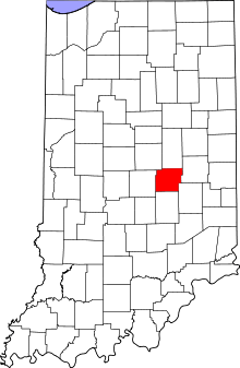 |
| Harrison County | 061 | Corydon | December 1, 1808 | Formed from Clark and Knox County | William Henry Harrison, governor of Indiana Territory and U.S. President | 31 | 39,364 | 485 sq mi (1,256 km2) | 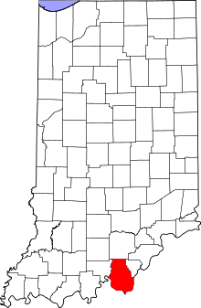 |
| Hendricks County | 063 | Danville | December 20, 1824 | Formed from Delaware and Wabash New Purchase | Governor of Indiana William Hendricks[11] | 32 | 145,488 | 407 sq mi (1,054 km2) | 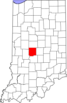 |
| Henry County | 065 | New Castle | December 31, 1821 | Formed from Delaware New Purchase | Patrick Henry, attorney, orator, and founding father | 33 | 49,462 | 392 sq mi (1,015 km2) | 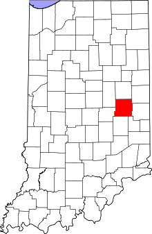 |
| Howard County | 067 | Kokomo | January 15, 1844[13] | Formed from un-organized | Gen. Tilghman Howard, a U.S. Representative from Indiana | 34 | 82,752 | 293 sq mi (759 km2) | 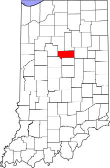 |
| Huntington County | 069 | Huntington | February 2, 1832 | Formed from Adams New Purchase and un-organized | Samuel Huntington, signer the Declaration of Independence | 35 | 37,124 | 383 sq mi (992 km2) | 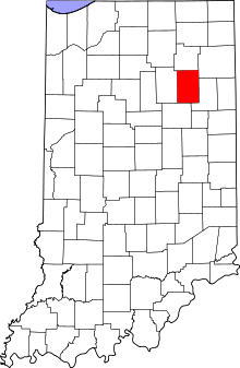 |
| Jackson County | 071 | Brownstown | January 1, 1816 | Formed from Clark, Jefferson and Washington | U.S. President Andrew Jackson | 36 | 42,367 | 509 sq mi (1,318 km2) | 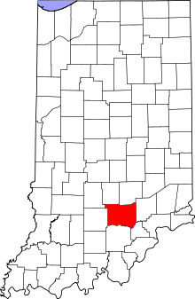 |
| Jasper County | 073 | Rensselaer | February 7, 1835 | Formed from Wabash New Purchase | Sgt. William Jasper, hero of the American Revolutionary War | 37 | 33,478 | 560 sq mi (1,450 km2) | 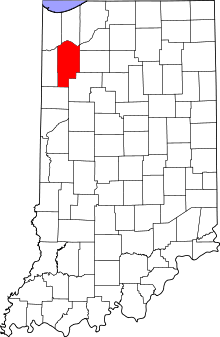 |
| Jay County | 075 | Portland | February 7, 1835 | Formed from Adams New Purchase | John Jay, first Chief Justice of the United States Supreme Court | 38 | 21,253 | 384 sq mi (995 km2) | 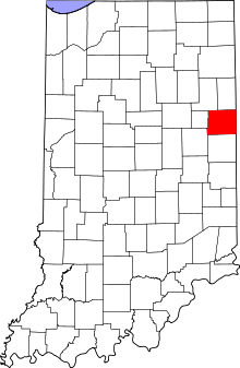 |
| Jefferson County | 077 | Madison | November 23, 1810 | Formed from Clark, Dearborn and Knox County | U.S. President Thomas Jefferson | 39 | 32,428 | 361 sq mi (935 km2) | 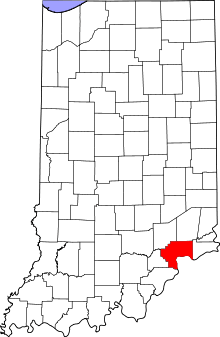 |
| Jennings County | 079 | Vernon | December 27, 1816 | Formed from Jackson and Jefferson Counties | Jonathan Jennings, first Governor of Indiana | 40 | 28,525 | 377 sq mi (976 km2) | 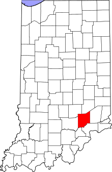 |
| Johnson County | 081 | Franklin | December 31, 1823 | Formed from Delaware New Purchase | John Johnson, first Chief Justice of the Indiana Supreme Court | 41 | 139,654 | 320 sq mi (829 km2) | 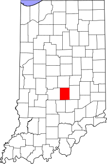 |
| Knox County | 083 | Vincennes | June 6, 1790 | Original County | U.S. Secretary of War Henry Knox | 42 | 38,440 | 516 sq mi (1,336 km2) | 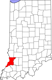 |
| Kosciusko County | 085 | Warsaw | February 7, 1835 | Formed from un-organized | Tadeusz Kościuszko, Polish-born hero of the American Revolutionary War and leader of a Polish nationalistic revolt against Russia | 43 | 77,358 | 531 sq mi (1,375 km2) | 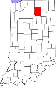 |
| LaGrange County | 087 | LaGrange | February 2, 1832 | Formed from un-organized | The ancestral estate of the Marquis de la Fayette, the French-born hero of the American Revolutionary War | 44 | 37,128 | 380 sq mi (984 km2) |  |
| Lake County | 089 | Crown Point | January 28, 1837 | Formed from Newton and Porter Counties | Its location on Lake Michigan | 45, 94, 96 | 496,005 | 499 sq mi (1,292 km2) | 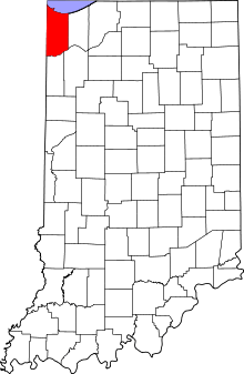 |
| LaPorte County | 091 | LaPorte | January 29, 1832 | Formed from St. Joseph and un-organized | Means the door in French, which refers to the city of LaPorte | 46 | 111,467 | 598 sq mi (1,549 km2) | 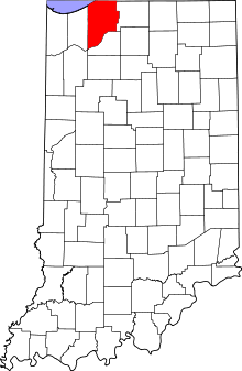 |
| Lawrence County | 093 | Bedford | January 7, 1818 | Formed from Orange | Capt. James Lawrence,[11] hero of the War of 1812 | 47 | 46,134 | 449 sq mi (1,163 km2) | 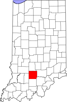 |
| Madison County | 095 | Anderson | January 4, 1823 | Formed from Delaware New Purchase | U.S. President James Madison | 48 | 131,636 | 452 sq mi (1,171 km2) | 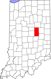 |
| Marion County | 097 | Indianapolis | December 31, 1821 | Formed from Delaware New Purchase | Gen. Francis Marion, American Revolutionary War hero | 49, 93-99 | 903,393 | 396 sq mi (1,026 km2) | 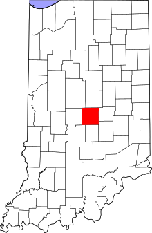 |
| Marshall County | 099 | Plymouth | February 7, 1835 | Formed from St. Joseph County | U.S. Chief Justice John Marshall | 50 | 47,051 | 444 sq mi (1,150 km2) | 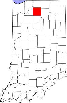 |
| Martin County | 101 | Shoals | January 17, 1820 | Formed from Daviess and Dubois Counties | Major John T. Martin, hero of the War of 1812 | 51 | 10,334 | 336 sq mi (870 km2) | 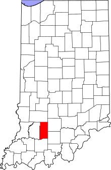 |
| Miami County | 103 | Peru | January 30, 1833 | Formed from Cass County and un-organized | Miami Native American people | 52 | 36,903 | 374 sq mi (969 km2) | 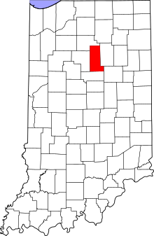 |
| Monroe County | 105 | Bloomington | January 14, 1818 | Formed from Orange County | U.S. President James Monroe | 53 | 137,974 | 395 sq mi (1,023 km2) | 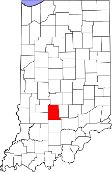 |
| Montgomery County | 107 | Crawfordsville | December 21, 1822 | Formed from Wabash New Purchase | Gen. Richard Montgomery, hero of the American Revolutionary War | 54 | 38,124 | 505 sq mi (1,308 km2) | 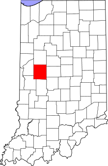 |
| Morgan County | 109 | Martinsville | December 31, 1822 | Formed from Delaware and Wabash New Purchase | Gen. Daniel Morgan, hero of the American Revolutionary War | 55 | 68,894 | 404 sq mi (1,046 km2) | 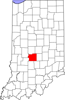 |
| Newton County | 111 | Kentland | December 8, 1859[14] | Formed from Jasper County | Sgt. John Newton, hero of the American Revolutionary War | 56 | 14,244 | 402 sq mi (1,041 km2) |  |
| Noble County | 113 | Albion | February 7, 1835 | Formed from un-organized | U.S. Senator James Noble or Governor of Indiana Noah Noble, brothers | 57 | 47,536 | 411 sq mi (1,064 km2) | 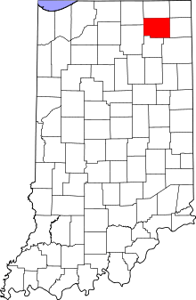 |
| Ohio County | 115 | Rising Sun | January 4, 1844 | Formed from Dearborn County | The Ohio River forms its east boundary | 58 | 6,128 | 86 sq mi (223 km2) |  |
| Orange County | 117 | Paoli | February 1, 1816 | Formed from Gibson, Knox and Washington | Orange County, North Carolina, in turn named for the Dutch Protestant House of Orange | 59 | 19,840 | 398 sq mi (1,031 km2) | 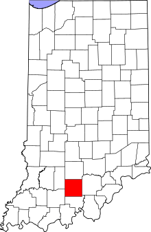 |
| Owen County | 119 | Spencer | December 21, 1818 | Formed from Daviess and Sullivan County | Abraham Owen,[11] hero of the Battle of Tippecanoe | 60 | 21,575 | 385 sq mi (997 km2) | 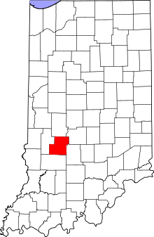 |
| Parke County | 121 | Rockville | January 9, 1821 | Formed from Vigo County | Benjamin Parke, a delegate of Indiana Territory to the U.S. Congress[11] | 61 | 17,339 | 445 sq mi (1,153 km2) | 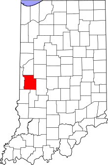 |
| Perry County | 123 | Tell City | November 1, 1814 | Formed from Gibson and Warrick Counties | Commodore Oliver Hazard Perry, hero of the War of 1812 | 62 | 19,338 | 382 sq mi (989 km2) | 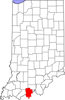 |
| Pike County | 125 | Petersburg | December 21, 1816 | Formed from Gibson and Perry County | Zebulon M. Pike, explorer of the American West | 63 | 12,845 | 334 sq mi (865 km2) | 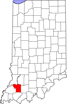 |
| Porter County | 127 | Valparaiso | February 7, 1835 | Formed from un-organized | Capt. David Porter, hero of the War of 1812 | 64 | 164,343 | 418 sq mi (1,083 km2) | 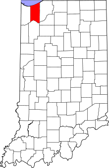 |
| Posey County | 129 | Mount Vernon | November 11, 1814 | Gibson County Warrick County | Thomas Posey, governor of Indiana Territory | 65 | 25,910 | 410 sq mi (1,062 km2) | 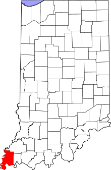 |
| Pulaski County | 131 | Winamac | February 7, 1835 | Formed from un-organized | Kazimierz Pułaski, Polish-born noble who led the colonial cavalry in the American Revolutionary War | 66 | 13,402 | 434 sq mi (1,124 km2) | 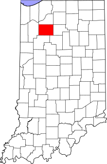 |
| Putnam County | 133 | Greencastle | December 31, 1822 | Formed from Owen County and Wabash New Purchase | Gen. Israel Putnam, hero of the American Revolutionary War | 67 | 36,019 | 481 sq mi (1,246 km2) | 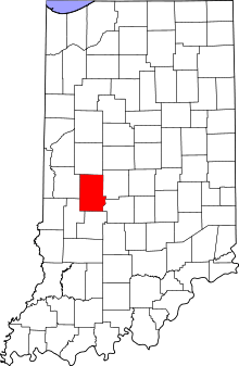 |
| Randolph County | 135 | Winchester | January 10, 1818 | Formed from Wayne County | Randolph County, North Carolina, which is named for first President of the Continental Congress Peyton Randolph | 68 | 26,171 | 452 sq mi (1,171 km2) | 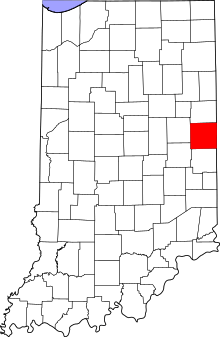 |
| Ripley County | 137 | Versailles | December 27, 1816 | Formed from Dearborn and Jefferson County | Gen. Eleazer Wheelock Ripley, hero of the War of 1812 | 69 | 28,818 | 446 sq mi (1,155 km2) | 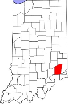 |
| Rush County | 139 | Rushville | December 31, 1821 | Formed from Delaware New Purchase | Dr. Benjamin Rush, signer the Declaration of Independence | 70 | 17,392 | 408 sq mi (1,057 km2) | 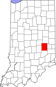 |
| St. Joseph County | 141 | South Bend | January 29, 1830 | Formed from un-organized | St. Joseph River, which flows through it toward Lake Michigan | 71 | 266,931 | 458 sq mi (1,186 km2) | 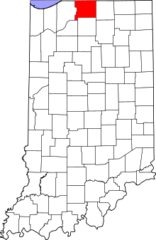 |
| Scott County | 143 | Scottsburg | January 12, 1820 | Formed from Clark, Jefferson, Jennings and Washington Counties | Charles Scott, Governor of Kentucky | 72 | 24,181 | 190 sq mi (492 km2) | 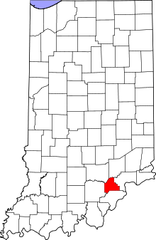 |
| Shelby County | 145 | Shelbyville | December 31, 1821 | Formed from Delaware New Purchase | Gen. Isaac Shelby, Governor of Kentucky | 73 | 44,436 | 411 sq mi (1,064 km2) | 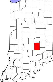 |
| Spencer County | 147 | Rockport | January 10, 1818 | Formed from Perry and Warrick Counties | Capt. Spier Spencer,[11] hero of the Battle of Tippecanoe | 74 | 20,952 | 397 sq mi (1,028 km2) | 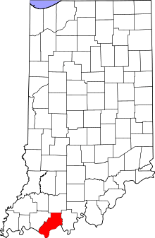 |
| Starke County | 149 | Knox | February 7, 1835 | Formed from St. Joseph County and un-organized | Gen. John Stark, hero of the American Revolutionary War | 75 | 23,363 | 309 sq mi (800 km2) | 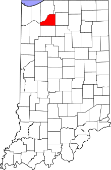 |
| Steuben County | 151 | Angola | February 7, 1837 | Formed from un-organized | Baron Frederick von Steuben, Prussian-born noble who trained colonial soldiers during the American Revolutionary War | 76 | 34,185 | 309 sq mi (800 km2) |  |
| Sullivan County | 153 | Sullivan | December 30, 1816 | Formed from Knox | General Daniel Sullivan, American Revolutionary War hero | 77 | 21,745 | 447 sq mi (1,158 km2) | 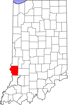 |
| Switzerland County | 155 | Vevay | October 1, 1814 | Formed from Dearborn and Jefferson County | The home country of many of the early settlers, Switzerland | 78 | 10,613 | 221 sq mi (572 km2) | 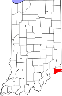 |
| Tippecanoe County | 157 | Lafayette | January 20, 1826 | Formed from Wabash New Purchase and un-organized | The Tippecanoe River and the Battle of Tippecanoe | 79 | 172,780 | 500 sq mi (1,295 km2) | 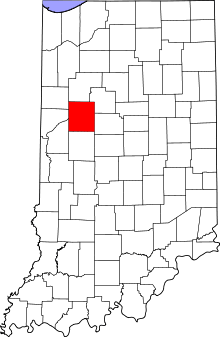 |
| Tipton County | 159 | Tipton | January 15, 1844 | Formed from Adams New Purchase and un-organized | John Tipton,[11] U.S. Senator | 80 | 15,936 | 261 sq mi (676 km2) | 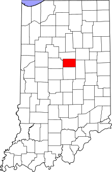 |
| Union County | 161 | Liberty | January 5, 1821 | Parts of Fayette, Franklin and Wayne counties | Named because it united sections of three adjacent counties into one new entity | 81 | 7,516 | 161 sq mi (417 km2) | 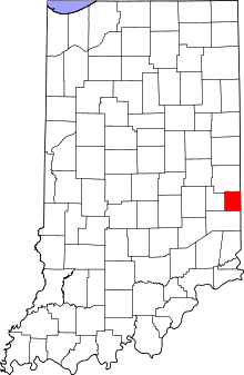 |
| Vanderburgh County | 163 | Evansville | January 7, 1818 | Gibson, Posey, and Warrick Counties | Henry Vanderburgh, a judge for Indiana Territory | 82 | 179,703 | 233 sq mi (603 km2) | 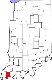 |
| Vermillion County | 165 | Newport | January 2, 1824 | Formed from Parke County and Wasbash New Purchase | The Vermillion River | 83 | 16,212 | 257 sq mi (666 km2) | 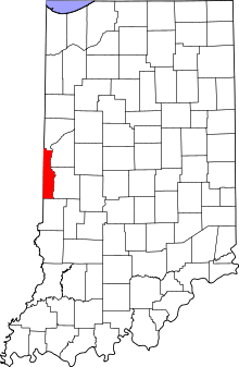 |
| Vigo County | 167 | Terre Haute | January 21, 1818 | Formed from Sullivan County | Francis Vigo, Italian-born colonial spy during the American Revolutionary War | 84 | 107,818 | 403 sq mi (1,044 km2) | 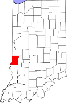 |
| Wabash County | 169 | Wabash | January 30, 1833[15] | Formed from Adams New Purchase and un-organized | The Wabash River | 85 | 32,888 | 412 sq mi (1,067 km2) | 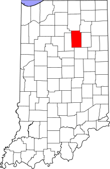 |
| Warren County | 171 | Williamsport | January 19, 1827 | Formed from Wabash New Purchase and un-organized | Dr. Joseph Warren, American Revolutionary War hero | 86 | 8,508 | 365 sq mi (945 km2) | 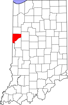 |
| Warrick County | 173 | Boonville | April 30, 1813 | Gibson and Knox Counties | Capt. Jacob Warrick,[11] hero of the Battle of Tippecanoe | 87 | 59,689 | 385 sq mi (997 km2) | 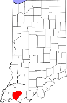 |
| Washington County | 175 | Salem | December 21, 1813 | Clark, Harrison and Knox Counties | U.S. President George Washington | 88 | 28,262 | 514 sq mi (1,331 km2) | 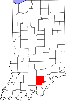 |
| Wayne County | 177 | Richmond | November 27, 1810 | Formed from Clark, Dearborn and Knox | Gen. "Mad" Anthony Wayne, hero of the American Revolutionary War | 89 | 68,917 | 402 sq mi (1,041 km2) | 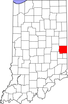 |
| Wells County | 179 | Bluffton | February 7, 1837 | Formed from Adams New Purchase | Capt. William A. Wells, Native American who became a hero in the War of 1812 | 90 | 27,636 | 368 sq mi (953 km2) | 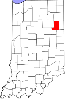 |
| White County | 181 | Monticello | February 1, 1834 | Formed from Wabash New Purchase and un-organized | Capt. Isaac White,[11] hero of the Battle of Tippecanoe | 91 | 24,643 | 505 sq mi (1,308 km2) | 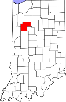 |
| Whitley County | 183 | Columbia City | February 7, 1835 | Formed from un-organized | Col. William Whitley,[11] hero of the Battle of Tippecanoe | 92 | 33,292 | 336 sq mi (870 km2) | 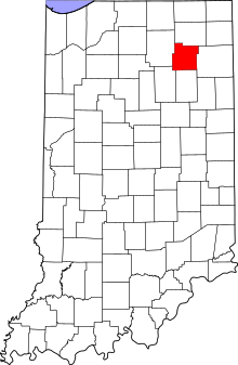 |
See also
References
- 1 2 "Population Estimates for Indiana Counties, 2010-2017". StatsIndiana. Retrieved June 1, 2018.
- 1 2 3 4 National Association of Counties. "NACo - Find a county". Retrieved 2014-06-01.
- ↑ "IN Const. art. XV, § 7 - Constitution of the State of Indiana, as amended". Indiana Legislature. 1851. Retrieved 2008-12-28.
- ↑ "FIPS Publication 6-4". National Institute of Standards and Technology. Retrieved 2007-04-11.
- ↑ "Indiana License Plates, 1969-Present". 2016-02-28.
- ↑ "EPA County FIPS Code Listing". EPA.gov. Retrieved 2008-02-23.
- 1 2 "Origin of Indiana County Names". Indiana Historical Bureau. Retrieved 2009-01-04.
- ↑ "Origin of Indiana County Names". 2009-01-04.
- ↑ "Indiana BMV website". 2016-02-28.
- ↑ "Indiana -- County". U.S. Census Bureau. Retrieved 2009-01-04.
- 1 2 3 4 5 6 7 8 9 10 11 12 13 14 15 16 Fought in the Battle of Tippecanoe
- ↑ Delaware County was originally formed on January 1, 1820, but for lack of population it was dissolved shortly thereafter. (Funk, p. 192)
- ↑ Originally named Richardville County for Chief Richardville, but renamed in 1872 (Funk, p. 193)
- ↑ Originally organized February 7, 1835 but merged with Jasper County in 1839 and recreated later. (Funk, p. 193)
- ↑ Originally formed January 20, 1820 but soon dissolved for lack of population. (Funk, p. 194)
- Sources
- Funk, Arville (1983) [1969]. A Sketchbook of Indiana History. Rochester, Indiana: Christian Book Press. pp. 192&ndash, 194.
