List of counties in Wisconsin
The U.S. state of Wisconsin is divided into 72 counties. The land that eventually became Wisconsin was transferred from British to American control with the 1783 signing of the Treaty of Paris.[1] It was an unorganized part of the Northwest Territory until 1802 when all of the land from St. Louis north to the Canadian border was organized as St. Clair County.[1] When Illinois was admitted to the union in 1818, Wisconsin became part of the Territory of Michigan and divided into two counties: Brown County in the northeast along Lake Michigan and Crawford County in the southwest along the Mississippi River.[1] Iowa County was formed in 1829 from the Crawford County land south of the Wisconsin River.[1] Brown County's southern portion was used to form Milwaukee County in 1834.[1] The state of Wisconsin was created from Wisconsin Territory on May 29, 1848, with 28 counties.
Counties in Wisconsin are governed by county boards, headed by a chairperson. Counties with a population of 500,000 or more must also have a county executive. Smaller counties may have either a county executive or a county administrator.[2] As of 2011, 13 counties had elected county executives: Brown, Chippewa, Dane, Fond du Lac, Kenosha, Manitowoc, Milwaukee, Outagamie, Portage, Racine, Sawyer, Waukesha, and Winnebago. 23 had an appointed county administrator, 34 had an appointed administrative coordinator, and 2 had neither an executive nor an administrator. Waukesha County had both an executive and an administrator.[3],
Each county has a county seat, often a populous or centrally located community, where the county's governmental offices are located. Some of the services provided by the county include: law enforcement, circuit courts, social services, vital records and deed registration, road maintenance, and snow removal. County officials include sheriffs, district attorneys, clerks, treasurers, coroners, surveyors, registers of deeds, and clerks of circuit court; these officers are elected for four-year terms. In most counties, elected coroners have been replaced by appointed medical examiners. State law permits counties to appoint a registered land surveyor in place of electing a surveyor.
The most populous county in the state is Milwaukee County at 947,735 people at the 2010 census.[4] Its population is bolstered by the city of Milwaukee's 594,833 people.[4] The county with the least population is Menominee County with 4,232 residents; the Menominee Indian Reservation is co-extensive with the county.[4] Pepin County is the smallest in area, with 231.98 square miles (600.8 km2); Marathon is the largest, having 1,544.91 square miles (4,001.3 km2).[4]
The Federal Information Processing Standard (FIPS) code, which is used by the United States government to uniquely identify states and counties, is provided with each entry.[5] Wisconsin's code is 55, which when combined with any county code would be written as 55XXX. The FIPS code for each county links to census data for that county.[6]
List of Counties
| County |
FIPS code[6] | County seat[7] | Established[8] | Formed from[9] | Etymology[9] | Population[4][7] | Area[4] | Map |
|---|---|---|---|---|---|---|---|---|
| Adams County | 001 | Friendship | 1848 | Portage County | John Quincy Adams (1767-1848), President of the United States (1825-29) |
20,875 | 645.65 sq mi (1,672 km2) |  |
| Ashland County | 003 | Ashland | 1860 | La Pointe County | Ashland, Henry Clay's estate in Kentucky |
16,157 | 1,045.04 sq mi (2,707 km2) |  |
| Barron County | 005 | Barron | 1859 | Polk County | Henry D. Barron, state senator and circuit court judge. |
45,870 | 862.71 sq mi (2,234 km2) |  |
| Bayfield County | 007 | Washburn | 1845 | St. Croix County | Henry Bayfield, Royal naval officer and first to survey Great Lakes area |
15,014 | 1,477.86 sq mi (3,828 km2) | 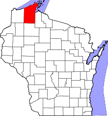 |
| Brown County | 009 | Green Bay | 1818 | unorganized territory | Major General Jacob Brown (1775-1828), commanding general of the United States Army during the War of 1812 |
248,007 | 529.71 sq mi (1,372 km2) | 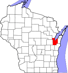 |
| Buffalo County | 011 | Alma | 1853 | Trempealeau County | The Buffalo River, which flows through the county. |
13,587 | 671.64 sq mi (1,740 km2) | 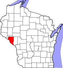 |
| Burnett County | 013 | Siren | 1856 | Polk County | Thomas P. Burnett, state legislator |
15,457 | 821.85 sq mi (2,129 km2) | 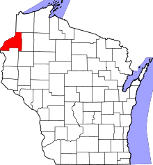 |
| Calumet County | 015 | Chilton | 1836 | Brown County, Wisconsin | The French word for a Menominee Ceremonial pipe. |
48,971 | 318.24 sq mi (824 km2) | 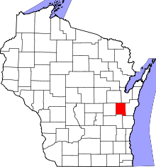 |
| Chippewa County | 017 | Chippewa Falls | 1845 | Crawford County | Chippewa Indians | 62,415 | 1,008.37 sq mi (2,612 km2) | 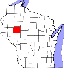 |
| Clark County | 019 | Neillsville | 1853 | Crawford County | George Rogers Clark (1752-1812), Revolutionary War general |
34,690 | 1,209.82 sq mi (3,133 km2) | 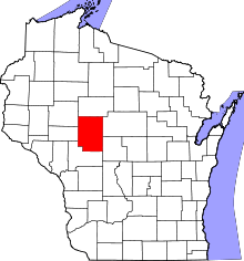 |
| Columbia County | 021 | Portage | 1846 | Portage County | Christopher Columbus (1451-1506), navigator and explorer |
56,833 | 765.53 sq mi (1,983 km2) | 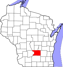 |
| Crawford County | 023 | Prairie du Chien | 1818 | unorganized territory | William Harris Crawford (1772-1834), United States Senator from Georgia (1807-13) and Secretary of the Treasury 1816-25 |
16,644 | 570.66 sq mi (1,478 km2) | 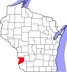 |
| Dane County | 025 | Madison | 1836 | Crawford, Iowa, and Milwaukee Countes | Nathan Dane (1752-1835), delegate to the First Continental Congress (1785-88) |
488,073 | 1,197.24 sq mi (3,101 km2) | 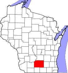 |
| Dodge County | 027 | Juneau | 1836 | Brown and Milwaukee Counties | Henry Dodge (1782-1867), Territorial Governor of Wisconsin (1848-57) |
88,759 | 875.63 sq mi (2,268 km2) | 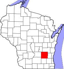 |
| Door County | 029 | Sturgeon Bay | 1851 | Brown County | A dangerous water passage near Door Peninsula known as Porte des Morts or "door of the dead" in French |
27,785 | 481.98 sq mi (1,248 km2) | 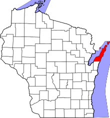 |
| Douglas County | 031 | Superior | 1854 | La Pointe County | Stephen Douglas (1813-61), United States Senator 1847-61 |
44,159 | 1,304.14 sq mi (3,378 km2) | 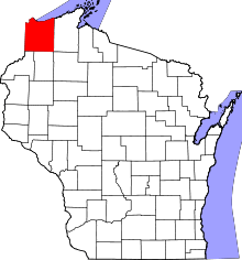 |
| Dunn County | 033 | Menomonie | 1854 | Chippewa County | Charles Dunn, state senator and chief justice of Wisconsin Territory |
43,857 | 850.11 sq mi (2,202 km2) | 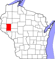 |
| Eau Claire County | 035 | Eau Claire | 1856 | Chippewa County | City of Eau Claire French for "clear water" |
98,736 | 637.98 sq mi (1,652 km2) | 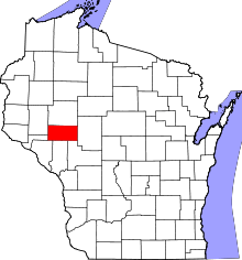 |
| Florence County | 037 | Florence (CDP) | 1881 | Marinette and Oconto Counties | Florence Julst, the first white woman to settle in the area |
4,423 | 488.20 sq mi (1,264 km2) |  |
| Fond du Lac County | 039 | Fond du Lac | 1836 | Brown County | French for "foot of the lake" |
101,633 | 719.55 sq mi (1,864 km2) | 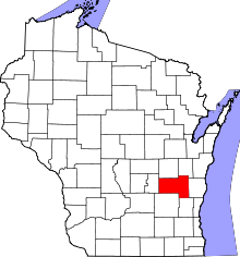 |
| Forest County | 041 | Crandon | 1885 | Langlade and Oconto Counties | Forest which covered the area when it was settled |
9,304 | 1,014.07 sq mi (2,626 km2) | 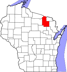 |
| Grant County | 043 | Lancaster | 1837 | Iowa County | Probably a trader named Grant who made contact with area natives in 1810 but about whom little else is known |
51,208 | 1,146.85 sq mi (2,970 km2) | 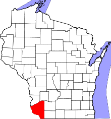 |
| Green County | 045 | Monroe | 1837 | Iowa County and unorganized territory | Nathanael Greene (1742-86), quartermaster general during the American Revolutionary War |
36,842 | 583.96 sq mi (1,512 km2) | 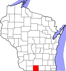 |
| Green Lake County | 047 | Green Lake | 1858 | Marquette County | Green Lake located within the county |
19,051 | 349.44 sq mi (905 km2) | 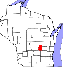 |
| Iowa County | 049 | Dodgeville | 1829 | Crawford County | Iowa tribe of Indians |
23,687 | 762.58 sq mi (1,975 km2) | 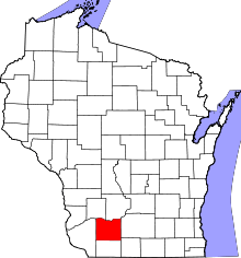 |
| Iron County | 051 | Hurley | 1893 | Ashland and Oneida Counties | Local iron deposits | 5,916 | 758.17 sq mi (1,964 km2) | 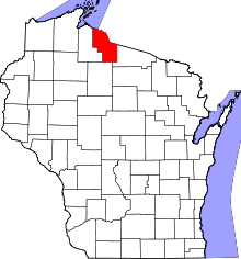 |
| Jackson County | 053 | Black River Falls | 1853 | La Crosse County | Andrew Jackson (1767-1845), President of the United States 1829–37 |
20,449 | 987.72 sq mi (2,558 km2) | 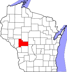 |
| Jefferson County | 055 | Jefferson | 1836 | Milwaukee County | Thomas Jefferson (1743-1826), President of the United States (1801-09) |
83,686 | 556.47 sq mi (1,441 km2) | 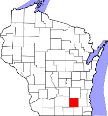 |
| Juneau County | 057 | Mauston | 1856 | Adams County | Solomon Juneau (1793-1856), founder of what would become Milwaukee |
26,664 | 766.93 sq mi (1,986 km2) | 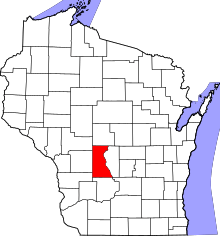 |
| Kenosha County | 059 | Kenosha | 1850 | Racine County | Indian word meaning "place of the pike" |
166,426 | 271.99 sq mi (704 km2) | 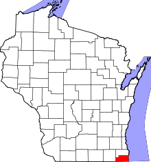 |
| Kewaunee County | 061 | Kewaunee | 1852 | Door County | Either a Potawatomi word meaning "river of the lost" or an Ojibwe word meaning "prairie hen" "wild duck" or "to go around" |
20,574 | 342.52 sq mi (887 km2) | 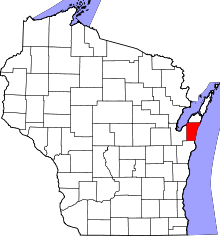 |
| La Crosse County | 063 | La Crosse | 1851 | Crawford County | Indian game of lacrosse |
114,638 | 451.69 sq mi (1,170 km2) | 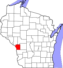 |
| Lafayette County | 065 | Darlington | 1846 | Iowa County | Gilbert du Motier marquis de La Fayette (1757-1834), a French general in the American Revolutionary War |
16,836 | 633.59 sq mi (1,641 km2) | 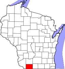 |
| Langlade County | 067 | Antigo | 1879 | Oconto County | Charles de Langlade (1729 – c.1800), American Revolutionary War veteran and United States Indian Agent in Green Bay |
19,977 | 870.64 sq mi (2,255 km2) | 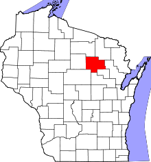 |
| Lincoln County | 069 | Merrill | 1874 | Marathon County | Abraham Lincoln (1809-65), President of the United States 1861-65 |
28,743 | 878.97 sq mi (2,277 km2) | 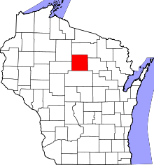 |
| Manitowoc County | 071 | Manitowoc | 1836 | Brown County | Munedoo-owk, an Ojibwe word meaning "the place of the good spirit" | 81,442 | 589.08 sq mi (1,526 km2) | 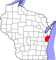 |
| Marathon County | 073 | Wausau | 1850 | Portage County | Marathon, Greece | 134,063 | 1,544.98 sq mi (4,001 km2) |  |
| Marinette County | 075 | Marinette | 1879 | Oconto County | Marie Antoinette Chevalier, Indian wife of an early fur trapper | 41,749 | 1,399.35 sq mi (3,624 km2) | 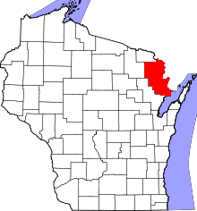 |
| Marquette County | 077 | Montello | 1836 | Brown County | Father Pere Jacques Marquette (1637-75), missionary and explorer |
15,404 | 455.60 sq mi (1,180 km2) | 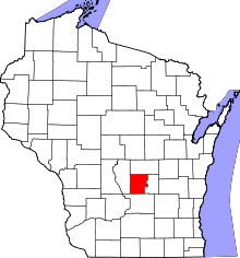 |
| Menominee County | 078 | Keshena | 1959 | Menominee Indian Reservation, Shawano, and Oconto Counties | Menominee Indians | 4,232 | 357.61 sq mi (926 km2) | 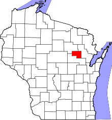 |
| Milwaukee County | 079 | Milwaukee | 1834 | Brown County | Mahnawaukee-Seepe, an Indian word meaning "gathering place by the river" |
947,735 | 241.40 sq mi (625 km2) | 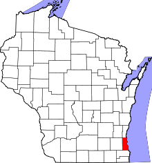 |
| Monroe County | 081 | Sparta | 1854 | La Crosse County | James Monroe (1758-1831), President of the United States (1817-25) |
44,673 | 900.78 sq mi (2,333 km2) | 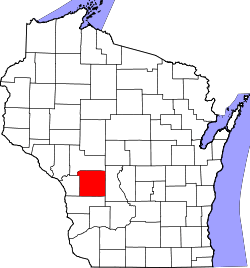 |
| Oconto County | 083 | Oconto | 1851 | Brown County | An Indian settlement and the Oconto River, whose name means "plentiful with fish" | 37,660 | 997.99 sq mi (2,585 km2) | 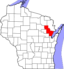 |
| Oneida County | 085 | Rhinelander | 1885 | Lincoln County | Oneida Indians | 35,998 | 1,112.97 sq mi (2,883 km2) | 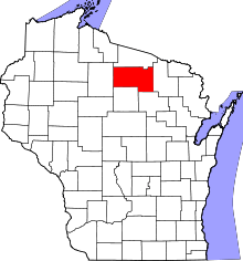 |
| Outagamie County | 087 | Appleton | 1851 | Brown County | Outagamie Indians | 176,695 | 637.52 sq mi (1,651 km2) | 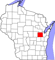 |
| Ozaukee County | 089 | Port Washington | 1853 | Washington County | The Ojibwe word for the Sauk nation | 86,395 | 233.08 sq mi (604 km2) | 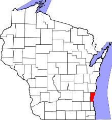 |
| Pepin County | 091 | Durand | 1858 | Dunn County | Pierre and Jean Pepin du Chardonnets, explorers | 7,469 | 231.98 sq mi (601 km2) | 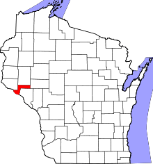 |
| Pierce County | 093 | Ellsworth | 1853 | Saint Croix County | Franklin Pierce (1804-69), President of the United States (1853-57) | 41,019 | 573.75 sq mi (1,486 km2) | 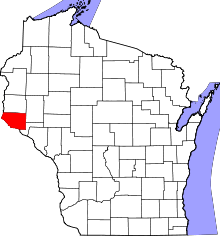 |
| Polk County | 095 | Balsam Lake | 1853 | Saint Croix County | James Polk (1795-1849), President of the United States (1845-49) |
44,205 | 913.96 sq mi (2,367 km2) | 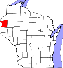 |
| Portage County | 097 | Stevens Point | 1836 | Brown, Crawford, Iowa, and Milwaukee Counties | Passage between the Fox and Wisconsin Rivers | 70,019 | 800.68 sq mi (2,074 km2) | 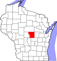 |
| Price County | 099 | Phillips | 1879 | Chippewa and Lincoln Counties | William T. Price (1824-86), United States Congressman (1883-86) |
14,159 | 1,254.38 sq mi (3,249 km2) | 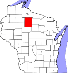 |
| Racine County | 101 | Racine | 1836 | Milwaukee County | Racine, the French word for "root", after the Root River, which flows through the county | 195,408 | 332.5 sq mi (861 km2) | 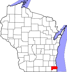 |
| Richland County | 103 | Richland Center | 1842 | Iowa County | The rich soil of the area | 18,021 | 586.15 sq mi (1,518 km2) | 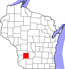 |
| Rock County | 105 | Janesville | 1836 | Milwaukee County | Rock River, which flows through the county | 160,331 | 718.14 sq mi (1,860 km2) | 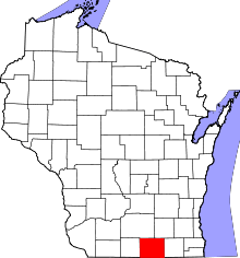 |
| Rusk County | 107 | Ladysmith | 1901 | Chippewa County | Jeremiah McLain Rusk (1830-93), Governor of Wisconsin 1882-89 | 14,755 | 913.59 sq mi (2,366 km2) | 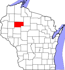 |
| Sauk County | 111 | Baraboo | 1840 | Crawford, Dane and Portage Counties | Sauk Indians | 61,976 | 830.9 sq mi (2,152 km2) | 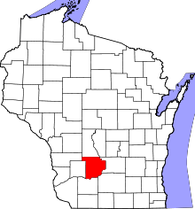 |
| Sawyer County | 113 | Hayward | 1883 | Ashland and Chippewa Counties, Wisconsin | Philetus Sawyer (1816-1900), United States Representative (1865-75) and Senator (1881-93) from Wisconsin |
16,557 | 1,257.31 sq mi (3,256 km2) | 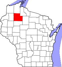 |
| Shawano County | 115 | Shawano | 1853 | Oconto County | An Ojibwe word meaning "southern" | 41,949 | 893.06 sq mi (2,313 km2) | 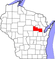 |
| Sheboygan County | 117 | Sheboygan | 1836 | Brown County | Shawb-wa-way-kun, an Indian word meaning "great noise underground" | 115,507 | 511.27 sq mi (1,324 km2) | 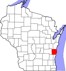 |
| St. Croix County | 109 | Hudson | 1840 | Crawford County, and unorganized territory | An early French explorer named St. Croix, about whom little is known | 84,345 | 722.33 sq mi (1,871 km2) |  |
| Taylor County | 119 | Medford | 1875 | Clark, Lincoln, Marathon and Chippewa Counties | William Robert Taylor (1820-1909), Governor of Wisconsin 1874-76 | 20,689 | 974.88 sq mi (2,525 km2) | 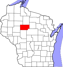 |
| Trempealeau County | 121 | Whitehall | 1854 | Crawford and La Crosse Counties | Trempealeau Mountain (from the French for "mountain with its foot in the water"), a bluff located in a bend of the Trempealeau River,[10] which flows through the county | 28,816 | 732.97 sq mi (1,898 km2) | 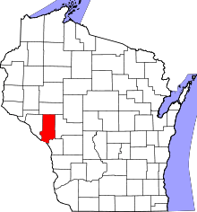 |
| Vernon County | 123 | Viroqua | 1851 | Richland and Crawford Counties | Mount Vernon, home of George Washington | 29,773 | 791.58 sq mi (2,050 km2) | 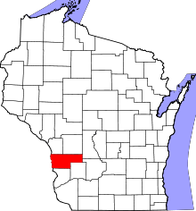 |
| Vilas County | 125 | Eagle River | 1893 | Oneida County | William Vilas (1840-1908), officer in the Civil War United States Postmaster General (1885-88) United States Secretary of the Interior (1888-89) and Senator from Wisconsin (1891-97) |
21,430 | 856.60 sq mi (2,219 km2) |  |
| Walworth County | 127 | Elkhorn | 1836 | Milwaukee County | Reuben Hyde Walworth (1788-1867), jurist from New York |
102,228 | 555.13 sq mi (1,438 km2) | 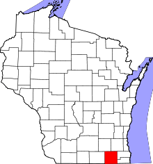 |
| Washburn County | 129 | Shell Lake | 1883 | Burnett County | Cadwallader Washburn (1818-82), Governor of Wisconsin (1872–74) and Representative from Wisconsin (1867–71) |
15,911 | 797.11 sq mi (2,065 km2) | 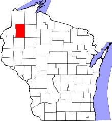 |
| Washington County | 131 | West Bend | 1836 | Brown and Milwaukee Counties | George Washington (1732-99), American Revolutionary War leader (1775–83) and first President of the United States (1789–97) |
131,887 | 430.70 sq mi (1,116 km2) | 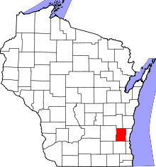 |
| Waukesha County | 133 | Waukesha | 1846 | Milwaukee County | Waugooshance, a Pottawatomi word meaning "little foxes" |
389,891 | 549.57 sq mi (1,423 km2) | 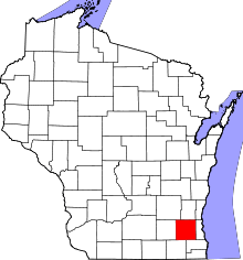 |
| Waupaca County | 135 | Waupaca | 1851 | Brown and Winnebago Counties | wau-pa-ka-ho-nak, a Menominee word meaning "white sand bottom" or "brave young hero" |
52,410 | 747.71 sq mi (1,937 km2) | 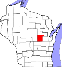 |
| Waushara County | 137 | Wautoma | 1851 | Marquette County | An Indian word meaning "good earth" |
24,496 | 626.15 sq mi (1,622 km2) | 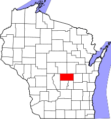 |
| Winnebago County | 139 | Oshkosh | 1840 | Brown, Calumet, and Fond du Lac Counties | Winnebago Indians | 166,994 | 434.49 sq mi (1,125 km2) | 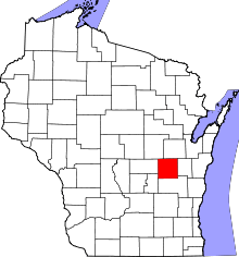 |
| Wood County | 141 | Wisconsin Rapids | 1856 | Portage County | Joseph Wood (1809-90), state legislator (1856-58) |
74,749 | 793.12 sq mi (2,054 km2) |  |
Renamed and proposed counties
Five counties in Wisconsin have been renamed and two have been proposed.
| County | Dates[11] | Etymology | Fate |
|---|---|---|---|
| Bad Ax(e) County | 1851–1862 | The Bad Axe River, Battle of Bad Axe (County variably named with 'Ax' or 'Axe' depending on source) |
Renamed Vernon County in 1862.[12] |
| Century County | 2011 | Proposed in 1997 for creation after the year 2000; the name was selected to represent "a new county for a new century".[13] | Because of issues with delivery of services by the county government, some residents of Marshfield proposed a new county to be created from several towns in Clark, Marathon, and Wood Counties, the city of Marshfield, and the village of Spencer.[13] |
| Dallas County | 1859–1869 | George M. Dallas (1792–1864) Vice President of the United States (1845–49) |
Renamed Barron County in 1869.[14] |
| Gates County | 1901–1905 | Milwaukee land speculator James L. Gates[15] | Renamed Rusk County in 1905.[16] |
| La Pointe County | 1845–1866 | Renamed Bayfield County in 1866.[17] | |
| New County | 1879–1880 | A new county formed from part of Oconto County | Renamed Langlade County in 1880[18] |
| Tuskola County | 1850 | proposed county to come from Washington County in 1850[9] Within modern Washington and Ozaukee counties |
See also
References
- 1 2 3 4 5 Curtiss-Wedge, Franklyn (1919). History of Buffalo and Pepin Counties, Wisconsin, Volume 1. Higginson Book Company. pp. 3–4.
- ↑ Wisconsin Legislative Reference Bureau. State of Wisconsin 2011-2012 Blue Book. Madison: Joint Committee on Legislative Organization, 2011, p. 736.
- ↑ Wisconsin Legislative Reference Bureau. State of Wisconsin 2011-2012 Blue Book. Madison: Joint Committee on Legislative Organization, 2011, p. 732.
- 1 2 3 4 5 6 "Wisconsin QuickFacts". U.S. Census Bureau. Archived from the original on 2013-03-03. Retrieved 2013-03-04. (2010 Census)
- ↑ "FIPS Publish 6-4". National Institute of Standards and Technology. Retrieved 2008-02-11.
- 1 2 "EPA County FIPS Code Listing". US Environmental Protection Agency. Retrieved 2008-02-11.
- 1 2 "NACo - Find a county". National Association of Counties. Retrieved 2008-02-11.
- ↑ Wisconsin Legislative Reference Bureau. State of Wisconsin 2011-2012 Blue Book. Madison: Joint Committee on Legislative Organization, 2011, p. 731.
- 1 2 3 Carver, Jonathon (1910). Proceedings of the State Historical Society of Wisconsin at its Fifty-Seventh Annual Meeting (1st ed.). Madison WI: Democrat Printing Company. (WV County Founding Dates and Etymology). Other editions available at ISBN 1130567257 and Google Books
- ↑ Elkins, Winston (1985). Trempealeau and the Mississippi River Dam. Trempealeau County, WI: Trempealeau County Historical Society.
- ↑ "Interactive Map of Wisconsin County Formation History". mapgeeks.org. Retrieved 2014-09-15.
- ↑ History of Vernon County, Wisconsin. Viroqua, WI: Union Publishing. 1884. p. 132. (Bad Ax County). Other editions available: ISBN 1178120341 and Google Books
- 1 2 "New county only solution to poor service, some say". The Journal Times. September 28, 1997. Retrieved 2017-01-09.
- ↑ "Dictionary of Wisconsin History". Wisconsin Historical Society. Retrieved 2013-02-27.
- ↑ Gannett, Henry (1905). The Origin of Certain Place Names in the United States. Govt. Print. Off. p. 135.
- ↑ Rusk County Museum Archived 2013-10-22 at the Wayback Machine.
- ↑ Wisconsin Historical Society-La Pointe County, Wisconsin (obsolete)
- ↑ 'History of Langlade County, Wisconsin from U.S. Government Survey to Present Time, With Biographical Sketches,' Robert Dessueran, Bernier Bros Publishing Co., Antigo, Wisconsin: 1922, History of Langlade County, Chapter V: Organization of Langlade County, pg. 12
External links
- Wisconsin historical county boundaries map from Atlas of Historical County Boundaries at Newberry Library website
