St. Charles, Illinois
| St. Charles City of St. Charles | |
|---|---|
| City | |
 Downtown St. Charles, with the Fox River and the Municipal Center/City Hall (the white Art Moderne building, built 1940) | |
| Nickname(s): STC (local abbreviation) | |
| Motto(s): Pride of the Fox[1] | |
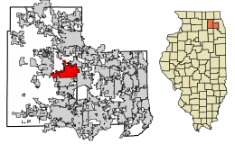 Location of St. Charles in Kane and DuPage Counties, Illinois. | |
.svg.png) Location of Illinois in the United States | |
| Coordinates: 41°54′49″N 88°18′39″W / 41.913744°N 88.31085°WCoordinates: 41°54′49″N 88°18′39″W / 41.913744°N 88.31085°W | |
| Country | United States |
| State | Illinois |
| County | Kane |
| Founded | 1834 (as Charleston; changed to St. Charles in 1839)[2] |
| Government | |
| Area[3] | |
| • Total | 15.02 sq mi (38.91 km2) |
| • Land | 14.70 sq mi (38.07 km2) |
| • Water | 0.33 sq mi (0.84 km2) |
| Population (2010) | |
| • Total | 32,974 |
| • Estimate (2016)[4] | 32,717 |
| • Density | 2,225.65/sq mi (859.31/km2) |
| Time zone | UTC−6 (CST) |
| • Summer (DST) | UTC−5 (CDT) |
| Area code(s) | 630 |
| FIPS code | 17-66703 |
| Website |
www |
St. Charles is a city[5] in DuPage and Kane counties in the U.S. state of Illinois. It lies roughly 40 miles (64 km) west of Chicago on Illinois Route 64. According to a U.S. Census Bureau estimate in July 2012, the city had a total population of 33,327.[6] The official city slogan is Pride of the Fox, after the Fox River that runs through the center of town. St. Charles is part of a tri-city area along with Geneva and Batavia, all western suburbs of similar size and relative socioeconomic condition.
History
Early history
St Charles was the location of the Native American community for the chief of the Pottawatomie that inhabited the area. A city park overlooking the river was dedicated to this Native American past.[7] After the Black Hawk War in 1832, the entire area of the Fox Valley was opened to American settlement. Evan Shelby and William Franklin staked the first claim in what is now St. Charles in 1833. They came back in 1834 with their families from Indiana, and were joined by over a dozen other families later that year. The township was initially known as Charleston, but this name was already taken by the downstate city of Charleston, Illinois so the name of St. Charles (suggested by S. S. Jones, a lawyer) was adopted in 1839.[8] St. Charles became incorporated as a city February 9, 1839 and reincorporated October 17, 1874 (under the 1870 Illinois Constitution).[9]
Underground Railroad
Several "stations" of the slavery-era Underground Railroad were in St. Charles homes, complete with tunnels and false doorways; there was also an open abolitionist group called the Kane County Anti-Slavery Society, founded in 1842, with about 180 members. Most accounts lead back to a local blacksmith who set up shop in a building now known as 305 W Main St. This was most likely "the hub," This address is the easiest to visit from the dozen "stations" known. As of 2015 a fine dining establishment holds residence at that address bearing a name in honor of that Blacksmith.
Transportation history
St. Charles was a very isolated place early on in its existence. The village was located three days away from Chicago, and the Fox River was not navigable for large boats. By the 1850s, St. Charles had begun construction of a plank road to Sycamore but turned down an offer by the Galena and Chicago Union Railroad to construct a line through the town, which was eventually built in nearby Elgin. Lack of regional connections in the early years kept the town relatively small. St. Charles was without a railroad until 1871 when a branch line from Geneva was constructed, and was without a direct connection to Chicago until the 1880s with the coming of the Chicago Great Western Railway.
Streetcar lines along the Fox River between Elgin and Aurora were built through the city in 1896, operated by the Aurora, Elgin and Fox River Electric company. A direct automobile route to Chicago, which eventually became Route 64 (Main Street), was constructed in 1920. Four Illinois state routes, including Routes 64, 38 (Lincoln Highway), 25 (5th Avenue) and 31 (2nd Street) now run through the city. Two major Kane County roads also cut through the city; Randall Road on the west side and Kirk Road on the east side.
Immigration history
St. Charles was also the place of settlement for diverse groups of European immigrants, including those from Ireland and Sweden during the 1840s and 1950s, and later, groups from Belgium and Lithuania.
Selected census results for St. Charles over time are:
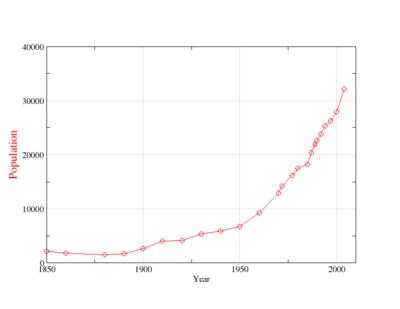
- 1850: 2,132
- 1860: 1,822
- 1880: 1,533
- 1890: 1,690
- 1900: 2,675
- 1910: 4,046
- 1920: 4,099
- 1930: 5,377
- 1940: 5,870
- 1950: 6,709[10]
- 1960: 9,269[11]
- 1970: 12,928
- 1972: 14,239
- 1977: 16,145
- 1980: 17,492
- 1985: 18,266
- 1987: 20,383
- 1989: 21,992
- 1990: 22,620
- 1992: 23,847
- 1994: 25,282
- 1997: 26,286
- 2000: 27,896
- 2004: 32,134
- 2008 (est.) 32,829[12]
- 2010: 32,974[6]
- 2012: 33,327[6]
Geography
According to the 2010 census, St. Charles has a total area of 14.934 square miles (38.68 km2), of which 14.61 square miles (37.84 km2) (or 97.83%) is land and 0.324 square miles (0.84 km2) (or 2.17%) is water.The Fox River runs though downtown. Potawatomie Park, which sits on the river is the largest park in St. Charles and a popular destination for both tourists and citizens tri-city area.[13]
Demographics
| Historical population | |||
|---|---|---|---|
| Census | Pop. | %± | |
| 1860 | 1,822 | — | |
| 1880 | 1,533 | — | |
| 1890 | 1,690 | 10.2% | |
| 1900 | 2,675 | 58.3% | |
| 1910 | 4,046 | 51.3% | |
| 1920 | 4,099 | 1.3% | |
| 1930 | 5,377 | 31.2% | |
| 1940 | 5,870 | 9.2% | |
| 1950 | 6,709 | 14.3% | |
| 1960 | 9,269 | 38.2% | |
| 1970 | 12,945 | 39.7% | |
| 1980 | 17,492 | 35.1% | |
| 1990 | 22,501 | 28.6% | |
| 2000 | 27,896 | 24.0% | |
| 2010 | 32,974 | 18.2% | |
| Est. 2016 | 32,717 | [4] | −0.8% |
| U.S. Decennial Census[14] | |||
According to the 2000 census, population density is 1,993.9 inhabitants per square mile (769.8/km2). There are 11,072 housing units at an average density of 791.4 per square mile (305.6/km²). The racial makeup of the city is 93.81% White, 1.66% African American, 0.14% Native American, 1.79% Asian, 0.00% Pacific Islander, 1.66% from other races, and 0.94% from two or more races. 5.50% of the population are Hispanic or Latino of any race.
There are 10,351 households out of which 36.4% have children under the age of 18 living with them, 61.1% are married couples living together, 8.0% have a female householder with no husband present, and 28.3% are non-families. 23.5% of all households are made up of individuals and 8.0% have someone living alone who is 65 years of age or older. The average household size is 2.62 and the average family size is 3.13.
In the city the population is spread out with 27.8% under the age of 18, 7.4% from 18 to 24, 29.6% from 25 to 44, 25.0% from 45 to 64, and 10.2% who are 65 years of age or older. The median age is 37 years. For every 100 females, there are 99.4 males. For every 100 females age 18 and over, there are 94.2 males.
The median income for a household in the city is $75,181, and the median income for a family is $94,704.[15] Males have a median income of $55,864 versus $35,134 for females. The per capita income for the city is $33,969. 3.4% of the population and 2.1% of families are below the poverty line. Out of the total population, 3.4% of those under the age of 18 and 3.9% of those 65 and older are living below the poverty line.
Government and infrastructure
State government
The Illinois Youth Center St. Charles (IYC St. Charles), a juvenile correctional facility of the Illinois Department of Juvenile Justice, is in St. Charles. It opened in December 1904.[16]
Education
The public education system in St. Charles is operated by the Community Unit School District 303, which currently has thirteen elementary schools: Anderson, Bell-Graham, Corron, Davis, Ferson Creek, Fox Ridge, Lincoln, Munhall, Norton Creek, Wasco, and Wild Rose. Also including Davis Primary (K-2), and Richmond Intermediate (3-5) split elementary schools.[17] There are two middle schools: Thompson and Wredling; and two high schools: St. Charles East High School, and St. Charles North High School. The Glenwood School for Boys and Girls has a campus in St. Charles known as the Rathje Campus named for the Frank C. Rathje family. St. Patrick Catholic School opened its doors in 1930 and currently serves about 500 students at the downtown campus. St. Charles is part of Community College District 509 which is served by Elgin Community College.
Culture
Also home of the Kane County Fair in July and the Kane County Flea Market the first Sunday and preceding Saturday of every month. Pottawatomie Park is the center of the annual Dragon Boat festival and family event, the second weekend of June. Downtown St. Charles' Lincoln Park serves as the central location for the Scarecrow Festival in October. St. Charles is also home to the Fox Valley Concert Band.
Saint Charles is also home to the Arcada theatre, a notable attraction within the Fox River valley, where many famous performers have appeared including Martin Short, Joan Rivers, and Bill Cosby.
Historic Hotel Baker which opened in 1928 is a symbolic representation of the rich history of downtown St. Charles. Rumors of it being haunted has drawn many tourists to St. Charles over the years.
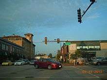
Downtown St. Charles was named one of the region's "Top 10" by the Chicago Tribune for fine dining, arts and entertainment, recreational opportunities, unique shopping, and a lively nighttime personality.[18]
Family Circle magazine named St. Charles #1 in its 2011 Annual Survey of Best Towns and Cities for families.[19] The comprehensive survey included communities from across the country and is featured in the magazine’s August 2011 issue. The communities in the magazine’s annual roundup of perfect places to call home combine affordable housing, good neighbors, green spaces, strong public school systems and giving spirits.
The St. Charles Heritage Center maintains two small museums in historic local buildings.
The St. Charles Public Library is nationally ranked[20] among the best libraries in the U.S. and has earned a "three star" rating in the 2010 Library Journal Index.[21] Located near downtown St. Charles, the library has a large collection of print materials, as well as DVDs, CDs, downloadable content, online research databases, and a genealogy collection. Programs and activities for children and adults are offered. Outreach Services can arrange special delivery options for those who have special circumstances, such as visual, mobility or hearing impairments. The Friends of the Library sponsors spring and fall book sales each year.
In 2008, as part of a promotional effort by a local water gardening company, St. Charles named itself the water garden capital of the world.[22]
St. Charles is home to the Q Center, a 95-acre conference site. Originally built as a Catholic Women's Liberal Arts College, St. Dominic College, it later became Arthur Andersen’s Center for Professional Education. It is now used by Accenture, and hosts meetings, conferences and executive learning for Fortune 500 companies, associations and social, military, education, religious and fraternal organizations from all over the world.[23]
Economy
Top employers
According to St. Charles' 2016 Comprehensive Annual Financial Report,[24] the top employers in the city are:
| # | Employer | # of Employees |
|---|---|---|
| 1 | St. Charles Community School District | 1,689 |
| 2 | RR Donnelley & Sons | 936 |
| 3 | Omron Automotive | 800 |
| 4 | City of St Charles | 300 |
| 5 | Armour-Eckrich Meats LLC | 289 |
| 6 | Jewel/Osco | 270 |
| 7 | Pheasant Run Resort | 250 |
| 8 | Do Paco | 191 |
| 9 | Dukane Corporation | 190 |
| 10 | System Sensor | 150 |
Notable people
- Edward J. Baker, wealthy benefactor; provided the funding for several buildings in St. Charles; born and raised in St. Charles
- Robert F. Casey, Illinois state legislator and lawyer, practiced law in St. Charles.[25]
- Frantz Hunt Coe, physician, public official, and educator
- Ethan Cutkosky, actor
- John F. Farnsworth, Union Army general and US congressman; friend of Abraham Lincoln; lived in St. Charles[26]
- Dennis E. Fitch, off duty pilot who took critical action to save lives during the United Airlines Flight 232 incident; died in St. Charles
- Jenny McCarthy, actress
- Tera Moody, long distance runner
- Karen Morrison-Comstock, Miss Illinois USA 1974, Miss USA 1974
- Michael J. Nelson, comedian and writer; (Mystery Science Theater 3000)
- David Purcey, left-handed relief pitcher for the Toronto Blue Jays, Oakland Athletics, Detroit Tigers, Philadelphia Phillies and Chicago White Sox
- Matt Reynolds, relief pitcher for the Arizona Diamondbacks
- Donnie Wahlberg, entertainer.[27]
- Brian Wilson, singer and member of the Beach Boys; lived in St. Charles
- Rick Wohlhuter, 1976 800m Olympic bronze medalist; born in St. Charles
- Randy Wright, former professional football quarterback, born and raised in St. Charles
- Chris Witaske, actor
See also
References
- ↑ "DuPage County IL Official Website - Page Not Found". www.dupageco.org.
- ↑ "Archived copy". Archived from the original on 2004-09-12. Retrieved 2008-01-27.
- ↑ "2016 U.S. Gazetteer Files". United States Census Bureau. Retrieved Jun 30, 2017.
- 1 2 "Population and Housing Unit Estimates". Retrieved June 9, 2017.
- ↑ "Incorporated Cities, Towns & Villages of Illinois" (PDF). State of Illinois, Secretary of State.
- 1 2 3 "2012 Population Estimates". Annual Estimates of the Resident Population: April 1, 2010 to July 1, 2012. U.S. Census Bureau. Retrieved 26 July 2013.
- ↑ 1917 Automobile Blue Book vol. c, page 274
- ↑ "Several Towns Named After Founders and Heroes". The Daily Herald. December 28, 1999. p. 220. Retrieved August 17, 2014 – via Newspapers.com.

- ↑ "Data" (PDF). cyberdriveillinois.com. July 2012.
- ↑ Source through 1950: John Clayton, The Illinois Fact Book and Historical Almanac, 1673-1968 (S. Ill. Univ. Press: Carbondale IL, 1970), p. 39-44.
- ↑ "Departments - City of St. Charles IL". City of St. Charles, Illinois.
- ↑ Bureau, U.S. Census. "American FactFinder - Community Facts". factfinder.census.gov.
- ↑ "G001 - Geographic Identifiers - 2010 Census Summary File 1". United States Census Bureau. Retrieved 2015-12-27.
- ↑ "Census of Population and Housing". Census.gov. Retrieved June 4, 2015.
- ↑ Bureau, U.S. Census. "American FactFinder - Community Facts". factfinder.census.gov.
- ↑ "Illinois Youth Center St. Charles." Illinois Department of Juvenile Justice. Retrieved on October 28, 2012. "4450 Lincoln Highway St. Charles, Il 60175"
- ↑ "About Us | Davis Richmond". dav-ric.d303.org. Retrieved 2017-09-07.
- ↑ "Community Profile - City of St Charles, IL". City of St. Charles, Illinois.
- ↑ "10 Best Towns for Families: 2011". Family Circle.
- ↑ "HAPLR 2.0". 26 January 2015.
- ↑ "Library Journal Index".
- ↑ Aquascape, Inc., St. Charles, IL Named Water Garden Capital of the World, press release (April 26, 2008).
- ↑ "St. Charles, IL Conference Centers - About Us - Q Center". Q Center.
- ↑ "City of St. Charles CAFR" (PDF).
- ↑ 'Illinois Blue Book 1961-1962, Biographical Sketch of Robert F. Casey, pg. 298
- ↑ "Population schedules of the 9th Census of the United States, 1870 Illinois". Roll: M593_237; Page: 473A. Retrieved 27 November 2017.
- ↑ Swartz, Tracy (April 25, 2016). "Reality Star Donnie Wahlberg: All Of St. Charles Knows What I'm Up To". Chicago Tribune.
External links
Municipalities and communities of Kane County, Illinois, United States | ||
|---|---|---|
| Cities | ||
| Villages | ||
| Townships | ||
| CDP | ||
| Other unincorporated communities |
| |
| Footnotes | ‡This populated place also has portions in an adjacent county or counties | |
Municipalities and communities of DuPage County, Illinois, United States | ||
|---|---|---|
| Cities | ||
| Villages |
| |
| Townships | ||
| Unincorporated communities | ||
| Ghost towns/Neighborhoods | ||
| Footnotes | ‡This populated place also has portions in an adjacent county or counties | |
| Major city |  | |
|---|---|---|
| Cities (over 30,000 in 2010) | ||
| Towns and villages (over 30,000 in 2010) |
| |
| Counties | ||
| Regions | ||
| Sub-regions | ||