List of counties in Nebraska
| Counties of Nebraska | |
|---|---|
 | |
| Location | State of Nebraska |
| Number | 93 |
| Populations | 458 (Arthur) – 537,256 (Douglas) |
| Areas | 241 square miles (620 km2) (Sarpy) – 5,961 square miles (15,440 km2) (Cherry) |
| Government | County government |
| Subdivisions | cities, towns, townships, unincorporated communities, indian reservations, census designated place |
The following is a list of the 93 counties in the U.S. state of Nebraska, listed by name, FIPS code and license plate prefix.
Nebraska's postal abbreviation is NE and its FIPS state code is 31.
When many counties were formed, the bills establishing them did not state the honoree's full name; thus the namesakes of several counties, including Brown, Deuel, Dixon, and possibly Harlan, are known only by their surnames.
County list
| County |
FIPS code[1] | County seat[2] | Established[2] | Origin | Etymology | License plate prefix [3] |
Population[2] | Area[2] | Map |
|---|---|---|---|---|---|---|---|---|---|
| Adams County | 001 | Hastings | 1867 | Unorganized territory | John Adams, Founding Father and the second President of the United States | 14 | 31,610 | 563 sq mi (1,458 km2) | 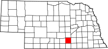 |
| Antelope County | 003 | Neligh | 1871 | Unorganized territory | Pronghorn, often called antelope | 26 | 6,456 | 857 sq mi (2,220 km2) | 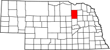 |
| Arthur County | 005 | Arthur | 1887 | Unorganized territory | Chester A. Arthur, twenty-first president of the United States | 91 | 458 | 715 sq mi (1,852 km2) | 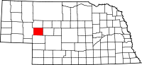 |
| Banner County | 007 | Harrisburg | 1888 | Formed from Cheyenne County | Named for the hope of the early settlers to make the county the "banner county" of the state | 85 | 759 | 746 sq mi (1,932 km2) | 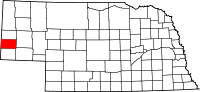 |
| Blaine County | 009 | Brewster | 1885 | Unorganized territory | James G. Blaine (1843-1923), Representative, Speaker of the House, Senator from Maine, Secretary of State, and Republican candidate in the 1884 presidential election | 86 | 482 | 711 sq mi (1,841 km2) | 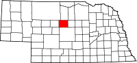 |
| Boone County | 011 | Albion | 1871 | Unorganized territory | Daniel Boone, American pioneer and trapper | 23 | 5,388 | 687 sq mi (1,779 km2) | 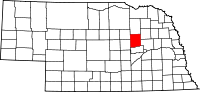 |
| Box Butte County | 013 | Alliance | 1887 | Formed from Dawes County | Named for a large box-shaped butte located approximately six miles north of Alliance, Nebraska, the county seat. | 65 | 11,305 | 1,075 sq mi (2,784 km2) | 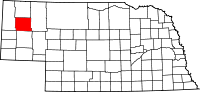 |
| Boyd County | 015 | Butte | 1891 | Holt County and unorganized territory (Indian Territory) | James E. Boyd, the eighth governor of Nebraska | 63 | 2,032 | 540 sq mi (1,399 km2) | 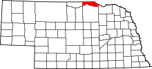 |
| Brown County | 017 | Ainsworth | 1883 | Unorganized territory | The Brown family of early settlers | 75 | 2,926 | 1,221 sq mi (3,162 km2) | 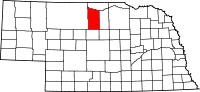 |
| Buffalo County | 019 | Kearney | 1855 | Unorganized territory | Named for the American Bison which once roamed the present county | 9 | 47,893 | 968 sq mi (2,507 km2) | 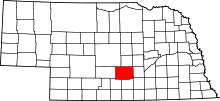 |
| Burt County | 021 | Tekamah | 1854 | One of nine original counties | Francis Burt, the first territorial governor of Nebraska who died after two days in office. | 31 | 6,574 | 493 sq mi (1,277 km2) | 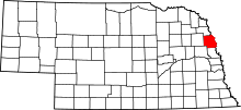 |
| Butler County | 023 | David City | 1856 | Formed from Greene County | William Orlando Butler, U.S. Congressman from Kentucky and Mexican–American War hero | 25 | 8,312 | 584 sq mi (1,513 km2) | 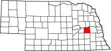 |
| Cass County | 025 | Plattsmouth | 1854 | One of nine original counties | Lewis Cass, the territorial administrator and U.S. Senator from Michigan | 20 | 25,357 | 559 sq mi (1,448 km2) | 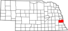 |
| Cedar County | 027 | Hartington | 1857 | Formed from Dixon and Pierce Counties | Named for the eastern red cedars present in the county[4] | 13 | 8,711 | 740 sq mi (1,917 km2) | 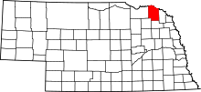 |
| Chase County | 029 | Imperial | 1873 | Unorganized territory | Champion S. Chase, a mayor of Omaha, Nebraska who served as Nebraska's first attorney general | 72 | 4,000 | 894 sq mi (2,315 km2) | 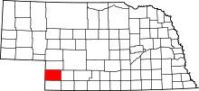 |
| Cherry County | 031 | Valentine | 1883 | Unorganized territory | Samuel A. Cherry, army lieutenant killed in the Indian Wars | 66 | 5,788 | 5,961 sq mi (15,439 km2) | 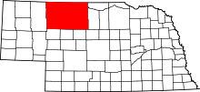 |
| Cheyenne County | 033 | Sidney | 1867 | Unorganized territory | Named for the Cheyenne Native American tribe | 39 | 10,091 | 1,196 sq mi (3,098 km2) | 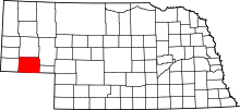 |
| Clay County | 035 | Clay Center | 1855 | Formed from unorganized territory | Henry Clay, the Senator from Kentucky, U.S. Secretary of State, and presidential candidate | 30 | 6,392 | 573 sq mi (1,484 km2) | 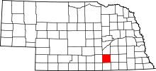 |
| Colfax County | 037 | Schuyler | 1869 | Formed from Platte County | Schuyler Colfax, Speaker of the U.S. House of Representatives and Vice President of the United States | 43 | 10,425 | 413 sq mi (1,070 km2) | 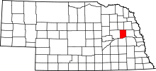 |
| Cuming County | 039 | West Point | 1855 | Formed from Burt County | Thomas B. Cuming, first Secretary of Nebraska Territory | 24 | 8,996 | 572 sq mi (1,481 km2) | 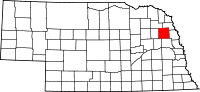 |
| Custer County | 041 | Broken Bow | 1877 | Unorganized territory | George Armstrong Custer, general in the Civil War and Indian Wars | 4 | 10,792 | 2,576 sq mi (6,672 km2) | 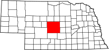 |
| Dakota County | 043 | Dakota City | 1855 | Formed from Burt County | Named for the Dakota branch of the Sioux Native American tribe | 70 | 20,947 | 264 sq mi (684 km2) | 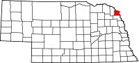 |
| Dawes County | 045 | Chadron | 1885 | Formed from Sioux County | James W. Dawes, the sixth governor of Nebraska | 69 | 9,088 | 1,396 sq mi (3,616 km2) | 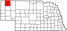 |
| Dawson County | 047 | Lexington | 1860 | Unorganized territory | Jacob Dawson, the first postmaster in present-day Lincoln, Nebraska, the state capital | 18 | 24,207 | 1,013 sq mi (2,624 km2) | 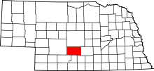 |
| Deuel County | 049 | Chappell | 1888 | Formed from Cheyenne County | The Deuel family of early settlers | 78 | 1,937 | 440 sq mi (1,140 km2) | 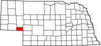 |
| Dixon County | 051 | Ponca | 1856 | Formed from Blackbird County, Izard County, and unorganized territory | The Dixon family of early settlers | 35 | 5,851 | 476 sq mi (1,233 km2) | 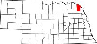 |
| Dodge County | 053 | Fremont | 1854 | One of nine original counties | Augustus Caesar Dodge, a United States senator from Iowa who was a supporter of the Kansas–Nebraska Act | 5 | 36,515 | 534 sq mi (1,383 km2) | 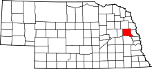 |
| Douglas County | 055 | Omaha | 1854 | One of nine original counties | Stephen Arnold Douglas, the American statesman, U. S. senator, and presidential candidate | 1 | 537,256 | 331 sq mi (857 km2) | 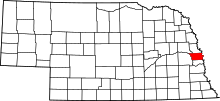 |
| Dundy County | 057 | Benkelman | 1873 | Unorganized territory | Elmer Scipio Dundy, a U.S. Circuit Court judge from Nebraska | 76 | 1,981 | 920 sq mi (2,383 km2) | 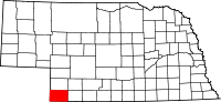 |
| Fillmore County | 059 | Geneva | 1856 | Formed from Jackson County and unorganized territory | Millard Fillmore, the thirteenth president of the United States | 34 | 5,698 | 576 sq mi (1,492 km2) | 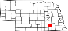 |
| Franklin County | 061 | Franklin | 1867 | Formed from Kearney County | Benjamin Franklin, the Founding Father, printer, scientist, and diplomat | 50 | 3,085 | 576 sq mi (1,492 km2) | 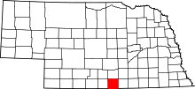 |
| Frontier County | 063 | Stockville | 1872 | Unorganized territory | Named for the fact that it was located in what was referred to at that time as part of the Nebraska frontier | 60 | 2,709 | 975 sq mi (2,525 km2) | 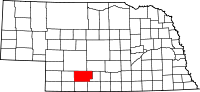 |
| Furnas County | 065 | Beaver City | 1873 | Unorganized territory | Robert Wilkinson Furnas, the third governor of Nebraska | 38 | 4,865 | 718 sq mi (1,860 km2) | 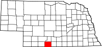 |
| Gage County | 067 | Beatrice | 1855 | Unorganized territory | William D. Gage, a Methodist minister who served as chaplain of the state legislature at the time the county was established | 3 | 21,864 | 855 sq mi (2,214 km2) | 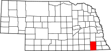 |
| Garden County | 069 | Oshkosh | 1910 | Formed from Deuel County | Named for the hopes of two real estate agents and citizens of the county seat, Oshkosh, Nebraska, that the county would be the "garden spot of the west" | 77 | 1,902 | 1,705 sq mi (4,416 km2) | 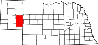 |
| Garfield County | 071 | Burwell | 1884 | Formed from Wheeler County | James Abram Garfield, the twentieth president of the United States | 83 | 2,035 | 570 sq mi (1,476 km2) | 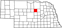 |
| Gosper County | 073 | Elwood | 1873 | Unorganized territory | John J. Gosper, the secretary of state for Nebraska at the time of the county's formation | 73 | 1,972 | 458 sq mi (1,186 km2) |  |
| Grant County | 075 | Hyannis | 1887 | Unorganized territory | Ulysses Simpson Grant, the eighteenth president of the United States and American Civil War general | 92 | 633 | 776 sq mi (2,010 km2) | 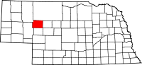 |
| Greeley County | 077 | Greeley | 1871 | Unorganized territory | Horace Greeley, the pioneering American journalist | 62 | 2,494 | 570 sq mi (1,476 km2) | 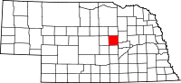 |
| Hall County | 079 | Grand Island | 1858 | Unorganized territory | Augustus Hall, the chief justice of the Territorial Supreme Court at the time the county was created | 8 | 60,720 | 546 sq mi (1,414 km2) | 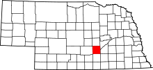 |
| Hamilton County | 081 | Aurora | 1867 | Unorganized territory | Alexander Hamilton, the first United States Secretary of the Treasury | 28 | 9,112 | 544 sq mi (1,409 km2) | 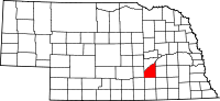 |
| Harlan County | 083 | Alma | 1871 | Formed from Kearney County | Disputed; either James Harlan, Secretary of the Interior 1865-1866; or a revenue collector named Harlan who lived near Republican City | 51 | 3,513 | 553 sq mi (1,432 km2) | 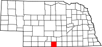 |
| Hayes County | 085 | Hayes Center | 1877 | Unorganized territory | Rutherford Birchard Hayes, the nineteenth president of the United States | 79 | 976 | 713 sq mi (1,847 km2) | 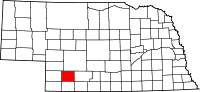 |
| Hitchcock County | 087 | Trenton | 1873 | Unorganized territory | Phineas Warren Hitchcock, a U.S. Senator from Nebraska | 67 | 2,872 | 710 sq mi (1,839 km2) | 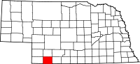 |
| Holt County | 089 | O'Neill | 1860 | Unorganized territory | Joseph Holt, a U.S. Postmaster General and U.S. Secretary of War under James Buchanan | 36 | 10,449 | 2,413 sq mi (6,250 km2) | 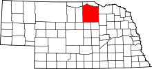 |
| Hooker County | 091 | Mullen | 1889 | Unorganized territory | Joseph Hooker, an American Civil War general | 93 | 738 | 721 sq mi (1,867 km2) | 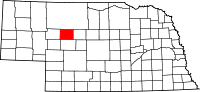 |
| Howard County | 093 | Saint Paul | 1871 | Formed from Hall County | Oliver Otis Howard, an American Civil War general | 49 | 6,355 | 570 sq mi (1,476 km2) | 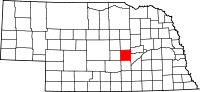 |
| Jefferson County | 095 | Fairbury | 1856 | Unorganized territory | Thomas Jefferson, the third president of the United States | 33 | 7,560 | 573 sq mi (1,484 km2) | 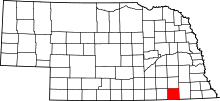 |
| Johnson County | 097 | Tecumseh | 1857 | Formed from Nemaha and Otoe Counties | Richard Mentor Johnson, the ninth vice president of the United States | 57 | 5,144 | 376 sq mi (974 km2) | 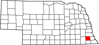 |
| Kearney County | 099 | Minden | 1860 | Unorganized territory | Named for Fort Kearny - when the county was created the fort's name was misspelled | 52 | 6,548 | 516 sq mi (1,336 km2) | 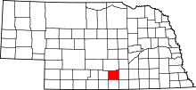 |
| Keith County | 101 | Ogallala | 1873 | Unorganized territory | M. C. Keith, who owned one of the largest ranches in western Nebraska at the time | 68 | 8,130 | 1,061 sq mi (2,748 km2) | 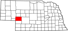 |
| Keya Paha County | 103 | Springview | 1884 | Formed from Brown County and unorganized Indian territory | Dakota words Ké-ya Pa-há Wa-kpá, which, translated, mean turtle hill river | 82 | 790 | 773 sq mi (2,002 km2) | 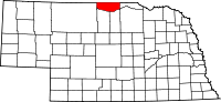 |
| Kimball County | 105 | Kimball | 1888 | Formed from Cheyenne County | Thomas L. Kimball, an official of the Union Pacific Railroad | 71 | 3,702 | 952 sq mi (2,466 km2) | 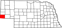 |
| Knox County | 107 | Center | 1857 | Formed from Pierce County and unorganized territory (Former names-L'Eau Qui Court (1857-1867) and Emmet (1867-1873)) | Henry Knox, the first United States Secretary of War | 12 | 8,565 | 1,108 sq mi (2,870 km2) | 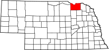 |
| Lancaster County | 109 | Lincoln | 1855 | Formed from Cass and Pierce Counties | The cities of Lancaster, Pennsylvania and Lancaster, England. | 2 | 297,036 | 839 sq mi (2,173 km2) | 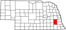 |
| Lincoln County | 111 | North Platte | 1860 | Unorganized territory | Abraham Lincoln, the sixteenth president of the United States | 15 | 36,051 | 2,564 sq mi (6,641 km2) | 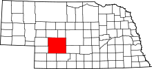 |
| Logan County | 113 | Stapleton | 1885 | Unorganized territory | John Alexander Logan, a general in the American Civil War | 87 | 763 | 571 sq mi (1,479 km2) | 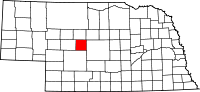 |
| Loup County | 115 | Taylor | 1883 | Unorganized territory | Loup River which in turn is named for the French word loup which means wolf | 88 | 576 | 570 sq mi (1,476 km2) | 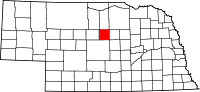 |
| Madison County | 119 | Madison | 1856 | Formed from Loup County, and McNeale County, and unorganized territory | Either James Madison, the fourth president of the United States; or, more likely, Madison, Wisconsin, where most of the new county's settlers were from | 7 | 35,278 | 573 sq mi (1,484 km2) | 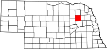 |
| McPherson County | 117 | Tryon | 1887 | Unorganized territory | James Birdseye McPherson, a general in the American Civil War | 90 | 526 | 859 sq mi (2,225 km2) | 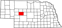 |
| Merrick County | 121 | Central City | 1858 | Formed from Polk County and unorganized territory | Elvira Merrick, wife of Henry W. DePuy, a territorial legislator | 46 | 7,802 | 485 sq mi (1,256 km2) | 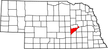 |
| Morrill County | 123 | Bridgeport | 1908 | Formed from Cheyenne County | Charles Henry Morrill, a president of the Lincoln Land Company | 64 | 4,908 | 1,424 sq mi (3,688 km2) | 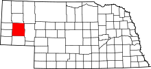 |
| Nance County | 125 | Fullerton | 1879 | Formed from a Pawnee Indian reservation | Albinus Nance, the fourth governor of Nebraska | 58 | 3,623 | 441 sq mi (1,142 km2) | 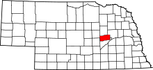 |
| Nemaha County | 127 | Auburn | 1854 | One of nine original counties | Nimaha, the Oto name meaning miry water for a stream which crossed the county and emptied into the Missouri River | 44 | 7,157 | 409 sq mi (1,059 km2) | 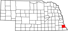 |
| Nuckolls County | 129 | Nelson | 1860 | Unorganized territory | Lafayette Nuckolls, a member of the first Nebraska territorial legislature; and his brother, Stephen Nuckolls, a pioneering Nebraska settler, businessman and banker | 42 | 4,413 | 575 sq mi (1,489 km2) | 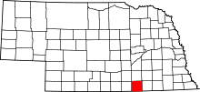 |
| Otoe County | 131 | Nebraska City | 1854 | One of nine original counties | Oto (also Otoe) Native American tribe | 11 | 15,752 | 616 sq mi (1,595 km2) | 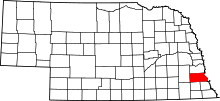 |
| Pawnee County | 133 | Pawnee City | 1855 | Formed from Richardson County | Pawnee Native American tribe | 54 | 2,709 | 432 sq mi (1,119 km2) | 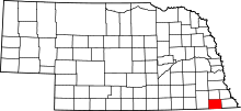 |
| Perkins County | 135 | Grant | 1887 | Formed from Keith County | Charles E. Perkins, a president of the Chicago, Burlington and Quincy Railroad | 74 | 2,921 | 883 sq mi (2,287 km2) | 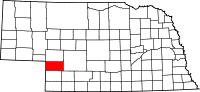 |
| Phelps County | 137 | Holdrege | 1873 | Formed from Kearney County | William Phelps, an early settler in that part of Nebraska[4] | 37 | 9,213 | 540 sq mi (1,399 km2) | 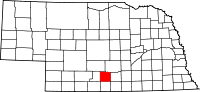 |
| Pierce County | 139 | Pierce | 1856 | Formed from Izard County, McNeale County, and unorganized territory | Franklin Pierce, the fourteenth president of the United States | 40 | 7,510 | 574 sq mi (1,487 km2) | 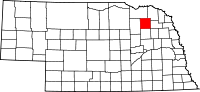 |
| Platte County | 141 | Columbus | 1856 | Formed from Greene and Loup Counties | Platte River which is in turn named for the French word for flat | 10 | 32,505 | 678 sq mi (1,756 km2) | 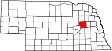 |
| Polk County | 143 | Osceola | 1856 | Formed from York County and unorganized territory | James Knox Polk, the eleventh president of the United States | 41 | 5,275 | 439 sq mi (1,137 km2) | 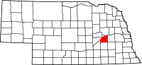 |
| Red Willow County | 145 | McCook | 1873 | Unorganized territory | Red Willow Creek, which runs through the area | 48 | 11,006 | 717 sq mi (1,857 km2) | 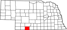 |
| Richardson County | 147 | Falls City | 1854 | One of nine original counties | William A. Richardson, a governor of the Nebraska Territory | 19 | 8,125 | 554 sq mi (1,435 km2) | 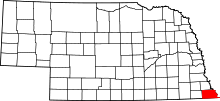 |
| Rock County | 149 | Bassett | 1885 | Formed from Brown County | Either Rock Creek, which flows in the county; or the rocky condition of the soil in the area | 81 | 1,411 | 1,008 sq mi (2,611 km2) | 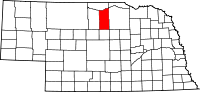 |
| Saline County | 151 | Wilber | 1867 | Unorganized territory | Named for a belief held by the early pioneers that great salt springs and deposits could be found in the area, a hope found to be false | 22 | 14,416 | 575 sq mi (1,489 km2) | 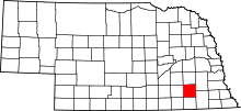 |
| Sarpy County | 153 | Papillion | 1857 | Formed from Cass and Douglas Counties | Peter A. Sarpy, a commander of a trading post in the future county | 59 | 169,331 | 241 sq mi (624 km2) | 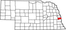 |
| Saunders County | 155 | Wahoo | 1856 | Formed from Douglas and Lancaster Counties | Alvin Saunders, a governor of the Nebraska Territory | 6 | 20,929 | 754 sq mi (1,953 km2) | 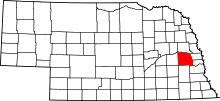 |
| Scotts Bluff County | 157 | Gering | 1888 | Formed from Cheyenne County | Named for a towering bluff located in the Scotts Bluff National Monument; the bluffs themselves are named for Hiram Scott, a fur trapper who is alleged to have crawled 75 miles with a broken leg before collapsing and dying at the foot of the formation | 21 | 36,848 | 739 sq mi (1,914 km2) | 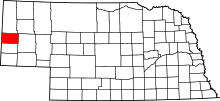 |
| Seward County | 159 | Seward | 1855 | Formed from Cass and Pierce Counties | William Henry Seward, the United States Secretary of State during the 1860s | 16 | 17,089 | 575 sq mi (1,489 km2) | 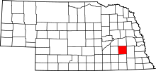 |
| Sheridan County | 161 | Rushville | 1885 | Formed from Sioux County | Philip Henry Sheridan, a general in the American Civil War | 61 | 5,251 | 2,441 sq mi (6,322 km2) | 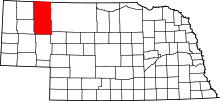 |
| Sherman County | 163 | Loup City | 1871 | Formed from Buffalo County and unorganized territory | William Tecumseh Sherman, the American Civil War general | 56 | 3,106 | 566 sq mi (1,466 km2) | 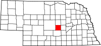 |
| Sioux County | 165 | Harrison | 1877 | Unorganized territory | Sioux Native American tribe | 80 | 1,475 | 1,313 sq mi (3,401 km2) | 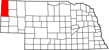 |
| Stanton County | 167 | Stanton | 1855 | Formed from Burt County | Edwin M. Stanton, the United States Secretary of War during most of the American Civil War | 53 | 6,133 | 430 sq mi (1,114 km2) | 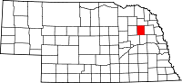 |
| Thayer County | 169 | Hebron | 1871 | Formed from Jefferson County | John Milton Thayer, the seventh governor of Nebraska | 32 | 5,189 | 575 sq mi (1,489 km2) | 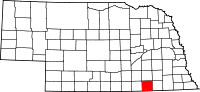 |
| Thomas County | 171 | Thedford | 1887 | Unorganized territory | George Henry Thomas, a general in the American Civil War | 89 | 699 | 713 sq mi (1,847 km2) | 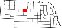 |
| Thurston County | 173 | Pender | 1889 | Formed form Blackbird County and an Omaha Indian reservation | John Mellen Thurston, a U. S. senator from Nebraska | 55 | 6,895 | 394 sq mi (1,020 km2) | 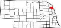 |
| Valley County | 175 | Ord | 1871 | Unorganized territory | Named for the many valleys in the area | 47 | 4,193 | 568 sq mi (1,471 km2) | 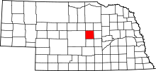 |
| Washington County | 177 | Blair | 1854 | One of nine original counties | George Washington, the first president of the United States | 29 | 20,223 | 390 sq mi (1,010 km2) | 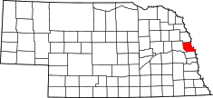 |
| Wayne County | 179 | Wayne | 1867 | Unorganized territory | Anthony Wayne, the American Revolutionary War general nicknamed "Mad Anthony" by his troops | 27 | 9,411 | 444 sq mi (1,150 km2) | 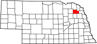 |
| Webster County | 181 | Red Cloud | 1867 | Unorganized territory | Daniel Webster, the statesman and U.S. Senator from Massachusetts | 45 | 3,688 | 575 sq mi (1,489 km2) | 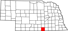 |
| Wheeler County | 183 | Bartlett | 1877 | Unorganized territory | Daniel H. Wheeler, a secretary of the Nebraska State Board of Agriculture | 84 | 759 | 575 sq mi (1,489 km2) | 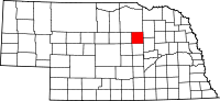 |
| York County | 185 | York | 1855 | Formed from Cass County, Pierce County, and unorganized territory | Named for either York, England, or York County, Pennsylvania | 17 | 13,883 | 576 sq mi (1,492 km2) | 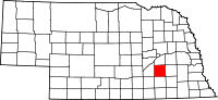 |
Former counties
- Clay (1855-1864) Formed from unorganized territory and dissolved into Gage and Lancaster County.
- Jackson (1855-1856) Formed from unorganized territory and dissolved to Fillmore County and unorganized territory
- Johnson (1855-1856) Formed from unorganized territory and dissolved to unorganized territory
- Blackbird (1855-1888) Formed from Burt County and dissolved to Thurston County
- Loup (1855-1856) Formed from Burt and Un-Organized and then dissolved Madison, Monroe and Platte Counties
- Jones (1856-1866) Formed from unorganized territory and dissolved into Jefferson County.
- Grant, Harrison, Jackson, Lynn, Monroe and Taylor counties listed in 1870 - see map
- West (1860-1862) Formed from unorganized territory and dissolved into Holt County
References
- ↑ "EPA County FIPS Code Listing". EPA.gov. Retrieved 2008-05-04.
- 1 2 3 4 National Association of Counties. "NACo County Explorer". Retrieved 2015-10-25.
- ↑ The license plate prefix sequence is derived from the number of vehicles registered in each county in 1922.
- 1 2 Fitzpatrick, Lilian Linder (1925). "Nebraska Place-Names". University of Nebraska Department of English. Retrieved 2010-09-02.
This article is issued from
Wikipedia.
The text is licensed under Creative Commons - Attribution - Sharealike.
Additional terms may apply for the media files.