Quincy, Illinois
| Quincy | ||
|---|---|---|
| City | ||
| City of Quincy | ||
 From left to right: The Bayview Bridge, Francis Hall on the Quincy University campus, Quincy Museum, Lincoln-Douglas debates mural in Washington Park, intersection of 8th and State in the South Side German Historic District, John Wood Mansion, neighborhood in the Northwest Historic District [top], the Oakley-Lindsay Center [bottom], the Gardner Museum of Architecture and Design. | ||
| ||
| Nickname(s): Gem City | ||
 Location of Quincy in Adams County, Illinois. | ||
.svg.png) Location of Illinois in the United States | ||
| Coordinates: 39°55′56″N 91°23′19″W / 39.93222°N 91.38861°WCoordinates: 39°55′56″N 91°23′19″W / 39.93222°N 91.38861°W | ||
| Country | United States | |
| State | Illinois | |
| County | Adams | |
| Government | ||
| • Type | Mayor-council | |
| • Mayor | Kyle A. Moore | |
| Area[1] | ||
| • City | 15.91 sq mi (41.20 km2) | |
| • Land | 15.87 sq mi (41.11 km2) | |
| • Water | 0.04 sq mi (0.09 km2) | |
| Elevation[2] | 568 ft (173 m) | |
| Population (2010) | ||
| • City | 40,633 | |
| • Estimate (2016)[3] | 38,531 | |
| • Density | 2,553.62/sq mi (985.93/km2) | |
| • Metro[4] | 77,406 | |
| Time zone | UTC−6 (CST) | |
| • Summer (DST) | UTC−5 (CDT) | |
| ZIP codes | 62301, 62305, 62306 | |
| Area code(s) | 217 | |
| FIPS code | 17-001-62380 | |
| Website |
www | |
Quincy (/ˈkwɪnsi/ KWIN-see), known as Illinois's "Gem City," is a city in and the county seat of Adams County, Illinois, United States,[5] located on the Mississippi River. The 2010 census counted a population of 40,633 in the city itself, up from 40,366 in 2000. As of July 1, 2015, the Quincy Micro Area had an estimated population of 77,220.[6]
During the 19th century, Quincy was a thriving transportation center as riverboats and rail service linked the city to many destinations west and along the river. It was Illinois' second-largest city, surpassing Peoria in 1870.[7] The city has several historic districts, including the Downtown Quincy Historic District and the South Side German Historic District, which display the architecture of Quincy's many German immigrants from the late 19th century.
History
Early history
Quincy's location along the Mississippi River has attracted settlers for centuries. The first known inhabitants to the region were of the Illiniwek tribe. Years later, following numerous incursions, the Sauk, Fox and Kickapoo also called the site home.
The French became the first European presence to colonize the region, after Louis Jolliet, Jacques Marquette and the La Salle Expeditions explored the Upper Mississippi River Valley. Fur goods became a valuable commodity of the region, and European explorers and merchants alike were attracted to the prospects of the growing fur trade of the North American frontier. The Mississippi River, acting as a superhighway for transporting goods downstream, became the area's most vital transportation asset.
Following the events of the Seven Years' War, which ended in 1763, Great Britain took control of New France, including that of the Illinois Territory. The Illinois Territory changed hands again a few decades later during the American Revolutionary War.
19th century
After the British failed to regain their former colonies in the War of 1812, the American government granted military tracts to veterans as a means to help populate the West. Peter Flinn, having acquired the land from veteran Mark McGowan for his military service in 1819, ended up selling 160 acres (0.65 km2) of land acquisitions to Moravia, New York native John Wood for $60. John Wood later founded Quincy, which at the time was coined Bluffs, Illinois.[8]
In 1825, Bluffs renamed their community Quincy and became the seat of government for Adams County, both named after newly elected President John Quincy Adams. In addition, they originally named the town square John Square until eventually changing it to Washington Square. Quincy incorporated as a city in 1840.
In 1838, following the signing of Missouri Executive Order 44, many members of the Church of Jesus Christ of Latter-day Saints fled persecution in Missouri and found shelter in Quincy. Despite being vastly outnumbered by Mormon refugees, residents provided food and lodging for the displaced people. Joseph Smith then led members of the Church of Jesus Christ of Latter-day Saints 40 miles (64 km) upstream to Nauvoo, Illinois, in hopes of finding a permanent home.[9] Also in 1838, Quincy sheltered the Pottawatomie tribe as they were forcibly relocated from Indiana to Kansas.[10]
The 1850s and 1860s brought increased prosperity to Quincy. Steamboats and railroads began linking Quincy to places west, making the city a frequent destination for migrants. The founding of the Chicago, Burlington and Quincy Railroad in 1855, and the construction of the Quincy Rail Bridge, were major drivers for creating a transportation hub in the region to further commerce.[11] It is during this time that the city's population grew enormously, from just under 7,000 residents in 1850 to 24,000 by 1870, helping Quincy surpass Peoria in becoming the second-largest city in the state (at that time).[7][12]
One famous former resident of Quincy is George E. Pickett. The future Confederate general as a young man came to Quincy to live, and learn the law, from his uncle Alexander Johnson in the 1840s. Johnson was acquainted with Abraham Lincoln, and Pickett and Lincoln may have even met each other in Quincy.[13]
In 1860, Quincy founder and Lieutenant Governor John Wood inherited the governorship after William H. Bissell died while in office. At the time, he was overseeing business interests and the construction of his mansion. The Illinois legislature allowed him to stay in Quincy during his tenure, effectively making Quincy a "second" capitol for the state. His absence from the official Governor's office in Springfield provided Abraham Lincoln a space for planning his Presidential run.[14]
The matter of slavery was a major religious and social issue in Quincy's early years. The Illinois city's location, separated only by the Mississippi River from the slave state of Missouri, which was a hotbed of political controversy on the issue, made Quincy itself a hotbed of political controversy on slavery.[15] Dr. Richard Eells, who was a staunch abolitionist, built his home in Quincy in 1835 and sheltered runaway slaves on their way to Chicago. His home became a major stop on the Underground Railroad.[16] The divide over slavery climaxed in 1858, when Quincy hosted the sixth Senatorial debate by U.S. Senator Stephen A. Douglas and his challenger, Abraham Lincoln. With an estimated crowd of 12,000 in attendance, Quincy was the largest community at which Lincoln and Douglas debated.[17][18]
Lincoln and Douglas again confronted each other in the 1860 Presidential election and the resulting campaign again divided Quincy and the surrounding region. Lincoln enthusiasts and Quincy's chapter of the Republican Party's para-military organization Wide Awakes, while en route to a political rally in Plainville, marched upon nearby Payson, which was a community predominantly filled with Douglas supporters. Although a confrontation was avoided while en route to Plainville, Douglas supporters shot upon the Wide Awakes on their journey back to Quincy, resulting in a skirmish known as the Stone Prairie Riots.[19]
The Civil War brought increasing prosperity to Quincy. Although the battles took place far from the city, Quincy was the organization site for several Illinois volunteer infantry regiments, including the 16th, 50th, 78th, 84th, 137th, 138th, and 151st. Following the Reconstruction Era, Quincy was selected as the location for Illinois' first Veteran's Home in 1886.[20]
Immigration to Quincy
Early immigrants to Quincy came predominately from New England, seeking better land. They brought with them progressive values, such as public education and abolitionism. Starting in the 1840s, migrants from Germany settled in Quincy to escape revolutions among the German provinces and conflicts between the European powers. German migrants mainly lived in close proximity to one another and settled predominantly in the southern parts of the city, influencing much of Quincy's historic architecture and creating the South Side German Historic District. Collectively, the south side of Quincy became known as Calftown, due to the fact that nearly every household possessed a cow.[21] Among the notable German-Americans from Quincy's Southside was Louise Maertz (1837-1918), a nurse during the American Civil War.[22]
In 1860, a group of Franciscan friars founded the St. Francis Solanus College, which later developed into Quincy University.
20th and 21st centuries
Throughout the 19th century, Quincy had grown from a backwater hamlet along the Mississippi River to become one of the state's most important cities and ports. Activity from rail and steamboat continued to flourish and Quincy benefited from the increased traffic. It was during the early decades of the 20th century that many of the city's historic buildings in the Downtown Quincy Historic District were constructed, including the city's first skyscraper, the Western Catholic Union Building, in 1925.[23]
The automobile and its surging popularity pushed Quincy to consider alternatives to Mississippi River crossings. Prior to the automobile, the most popular means of crossing the near-mile wide river was by boat or ferry. The need for a bridge was apparent. In 1928, construction began on the Memorial Bridge which was a two-lane truss toll bridge; it opened in May 1930. By 1945, the city had repaid its outstanding bonds and eliminated the toll.[24]
On April 12, 1945, a tornado ripped through the business district of Quincy and severely damaged the courthouse. The wind was so severe that it blew the roof off the structure, damaging it beyond repair.[25] Because the incident occurred a few hours after news reached Quincy of President Roosevelt's death, several residents joked that "FDR and God were just fighting over the power up there."[26] Five years passed before a new courthouse was completed.[27]
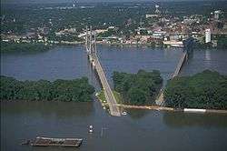
In 1987, the cable-stayed Bayview Bridge was constructed to help alleviate traffic on the aging Memorial Bridge. Today, both bridges complement each other by carrying westbound (Bayview) and eastbound (Memorial) traffic. Although lighting was originally intended for the Bayview Bridge during its construction phase, the actual installation of lights didn't occur until 2015.[28]
During the Mississippi River flood of 1993, riverside businesses and industries suffered extensive damage when the river crested at a record 32.2 feet (9.81 m), 15 feet (4.6 m) above flood stage. For a time, the Bayview Bridge, one of Quincy's two bridges, was the only bridge open across the Mississippi River between Alton, Illinois and Burlington, Iowa. The Memorial Bridge was closed from the end of June, due to water over its western approach. On July 16, 1993, the Bayview Bridge closed for 40 days when the river submerged the land on the west side of the Mississippi River at Taylor, Missouri.
A flood in June 2008 submerged much of Quincy's riverfront and low-lying regions not protected by the bluffs. Record Mississippi River levels occurred on June 22, 2008. The Red Cross[29] accepted donations for Quincy and other communities in Adams County, as natural disaster funds were depleted in 2010.
Quincy has been twice recognized as an All-America City and is a participant in the Tree City USA program. In the fall of 2010, Forbes Magazine listed Quincy as the eighth "Best Small City To Raise A Family."[30]
Demographics
| Historical population | |||
|---|---|---|---|
| Census | Pop. | %± | |
| 1840 | 2,319 | — | |
| 1850 | 6,902 | 197.6% | |
| 1860 | 13,718 | 98.8% | |
| 1870 | 24,052 | 75.3% | |
| 1880 | 27,268 | 13.4% | |
| 1890 | 31,494 | 15.5% | |
| 1900 | 36,252 | 15.1% | |
| 1910 | 36,587 | 0.9% | |
| 1920 | 35,978 | −1.7% | |
| 1930 | 39,241 | 9.1% | |
| 1940 | 40,469 | 3.1% | |
| 1950 | 41,450 | 2.4% | |
| 1960 | 43,793 | 5.7% | |
| 1970 | 45,288 | 3.4% | |
| 1980 | 42,554 | −6.0% | |
| 1990 | 39,681 | −6.8% | |
| 2000 | 40,366 | 1.7% | |
| 2010 | 40,633 | 0.7% | |
| Est. 2016 | 40,531 | [3] | −0.3% |
| U.S. Decennial Census[31] | |||
As of the census[32] of 2010, there were 40,633 people, 17,151 households, and 9,964 families residing in the city. The population density was 2,761.2 people per square mile (1,066.0/km2). There were 18,043 housing units at an average density of 1,234.2 per square mile (476.5/km2). The racial makeup of the city was 90.8% White, 5.4% African American, 0.2% Native American, 0.9% Asian, 0.4% from other races, and 2.2% from two or more races. Hispanic or Latino of any race were 1.4% of the population.
There were 16,546 households out of which 28.6% had children under the age of 18 living with them, 46.3% were married couples living together, 11.6% had a female householder with no husband present, and 38.9% were non-families. 33.7% of all households were made up of individuals and 15.3% had someone living alone who was 65 years of age or older. The average household size was 2.30 and the average family size was 2.94.
In the city, the population was spread out with 22.3% under the age of 18, 10.0% from 18 to 24, 25.8% from 25 to 44, 20.9% from 45 to 64, and 19.9% who were 65 years of age or older. The median age was 38 years. For every 100 females, there were 88.3 males. For every 100 females age 18 and over, there were 85.3 males.
The median income for a household in the city was $30,956, and the median income for a family was $40,718. Males had a median income of $30,734 versus $20,748 for females. The per capita income for the city was $17,479. About 9.2% of families and 12.2% of the population were below the poverty line, including 15.2% of those under age 18 and 8.3% of those age 65 or over.
Geography
Quincy is located at 39°55′56″N 91°23′19″W / 39.93222°N 91.38861°W (39.932335, -91.388737).[33] It is adjacent to the Mississippi River and Quincy Bay, a large inlet of water fed by Cedar and Homan Creeks. According to the 2010 census, Quincy has a total area of 15.946 square miles (41.30 km2), of which 15.91 square miles (41.21 km2) (or 99.77%) is land and 0.036 square miles (0.09 km2) (or 0.23%) is water.[34]
The city is situated on bluffs overlooking the Mississippi River. Adjacent to Quincy, on the Missouri side of the river, is West Quincy, Missouri and a vast floodplain used primarily for farming. East of Quincy lies the Quincy Hills geographic region, a region of hills that are similar to the Lincoln Hills in Missouri, where a mixture of rolling hills, woods, and farming shape the landscape. Flat prairie lie north of Quincy and, as the Mississippi turns sharply to the southwest; bluffs, floodplain, and farmland lie to the south and southwest of the city.
The Quincy micropolitan area includes Adams County, Illinois and Lewis County, Missouri and together hold a population of 77,314. Due to its proximity to Hannibal, Missouri, the two communities have been bulked into Quincy-Hannibal, IL-MO Combined Statistical Area which holds approximately 116,000 residents. As of the 2010 Census, it is currently ranked as the 156th most populated CSA in the United States.
Geographically, Quincy is the largest city and central hub of the Tri-State region, encompassing western Illinois, northeastern Missouri, and southeastern Iowa.
Quincy holds several suburbs on its borders or in close proximity. North Quincy is the city's most populated suburb and lies to the north, beyond a rail line and a large creek. Hickory Grove, Illinois is an edge town and lies adjacent to Quincy to its east, bordered by Interstate 172. The town of Marblehead lies to the south, and West Quincy to the west.
The nearby Hannibal–Quincy micropolitan areas are also technically not located within the metropolitan, but are regionally associated due to their proximity and accessibility to Greater St. Louis.
Sister cities
Quincy, Illinois has two sister cities.
Economy
Companies based in Quincy include Niemann Foods, Gardner Denver and The Knapheide Manufacturing Company. GatesAir Television and Radio Transmission has a facility in town, as does Broadcast Electronics. Titan Wheel (Titan International) is also located in Quincy. Blessing Hospital, the Quincy Public Schools and Titan are the top three employers in the area.[37]
In 1978, Quincy formed the Great River Economic Development Foundation, a private, non-profit organization designed to retain existing businesses and attract new ones to the area. This organization has been instrumental in putting the Quincy-Hannibal Area on the map as a distinct region in conjunction with the major metropolitan areas nearby such as Chicago, IL, St. Louis, MO, and even Kansas City, MO.[37] As a whole, Quincy falls from average to just above average in several economic categories[38] in comparison to the national averages.
The cost of living in Quincy is well below the national average.[39] The city is also below the national averages in cost of food, utilities and other miscellaneous costs.[39] In the fall of 2010 Quincy was listed as eighth in the top fifteen small cities to raise a family in the United States by Forbes magazine for its commute times, high school graduation rate, median household income, home ownership rate and cost of living. Forbes compared 126 cities with a population under 100,000 and ranked them on these five quality-of-life measures.[40]
Media
Quincy's television market includes the cities of Quincy, Hannibal, Burlington, Macomb, and Keokuk. The market was widely served by Insight Communications through 2007. In January 2008, Comcast took control of the cable television system. Satellite television services are provided by DirecTV or Dish Network.
The city is usually combined with Hannibal due to their proximity and labeled as the 170th market on the DMA chart. With regards to television service, Quincy and the surrounding region are served by affiliates of ABC, CBS, NBC, Fox, and the CW networks. STARadio Corporation and Quincy Newspapers own many of the local media in the region. Quincy Newspapers also owns the Quincy Herald-Whig, which is the most widely read newspaper in the region. As of February 2006, Quincy can receive 17 FM stations, 5 AM stations, and one NOAA Wideband Weather Radio station.[41]
Culture
Quincy and the surrounding region lie in a blended zone of midwestern culture, where influences from the Heartland and Rust Belt converge. It is also a community that deeply admires the arts, as it is home to America's first Arts Council, Quincy Society of Fine Arts"", which was founded in 1947 by George M. Irwin"". Irwin also founded Quincy Little Symphony (today known as Quincy Symphony Orchestra Association"") in 1947. Numerous nonprofit arts organizations provide the community with opportunities for entertainment, workshops, hands-on creative experiences, annual festivals, gallery and museum exhibit openings, theatre, architecture, education and much more. Quincy was also named to Expedia's list of America's Most Artistic Towns"" in 2017 and 2018.
Like most Mississippi river cities, blues music has made a lasting impression upon the city and every year the free admission Blues in the District concert series brings the music to Washington Park, where artists are invited to sing and play for spectators the second and fourth Friday of June, July and August. Free music events are also offered by the Quincy Park Band"" throughout the summer and Quincy Concert Band"" twice a year.
The Dogwood Parade and festival is an annual event held in early-May celebrating the blossoming Dogwoods located throughout the city. Washington Park hosts amusement rides and a parade marches down Maine Street. Washington Park and downtown also become the focal point of activity for farmer's markets, Q-Fest, formerly the Midsummer Arts Faire,[42] the Tin Dusters, and the Gus Macker 3-on-3 Basketball tournament.
The Historical Society of Quincy and Adams County""engage the community in various events at the History Museum, the John Wood Mansion and Woodland Cemetery. In 2018, Quincy Community Theatre"" opened its 81st season. Quincy Art Center"" and Quincy Museum"" host the annual Art Fest & Folk Life Festival on Maine Street each September and provide various educational opportunities.
Quincy's riverfront is also a center for popular activities throughout the year, including the Fourth of July display on the Quincy Bay, outdoor showings of movies, and concerts. The Quincy Area Convention and Visitors Bureau"" is housed in a unique example of Mediterranean Revival architecture, the Villa Kathrine"", along the river bluff and provides visitors and those traveling along the Great River Road"" a stop with informational materials about Quincy and the surrounding area.
The Historic Downtown District is the premier destination for dining, entertainment and shopping. With the backdrop of historic architecture, The District"" merges the past with a touch of modern flair to bring customers all the modern conveniences they would want. Broadway Street leads from the Mississippi River through the east end of the town. Along the route are numerous chain franchises, stores, Quincy Mall and various strip malls for additional shopping opportunities. The Quincy Area Chamber of Commerce"" was established in 1887 to promote and enhance the business climate and economic well being of the Quincy area.
Residents are also very conscious of their health and overall well being[43]. The Quincy YMCA"" and The Salvation Army Kroc Center"" provide fitness and recreational activities. There also several dance and yoga studios available. The Quincy Park District"" also offers the public access to numerous parks, trails, facilities and programs throughout the city.
Architecture

Quincy is home to a diverse and vibrant collection of buildings that have come to be a tourist attraction in and of themselves. South of downtown is the South Side German Historic District, which holds many of the German-influenced structures that early immigrants built. A central site in the district is the Dick Bros. Brewery Building, which was constructed in 1857 and rivaled many larger breweries.[44] The effects of Prohibition forced the brewery into bankruptcy, but the building remains and is being renovated for loft and commercial space.[45] Other examples of rich German-influence in Quincy can also be seen in the many brick homes within the district.
Francis Hall of Quincy University is another example of German influence in the city's structures.
Other than the South Side, Maine Street and the East End are popular strips where Quincy's rich architectural history is displayed. Once housing some of Quincy's elite, many of the homes in these regions are influenced mainly by Victorian schools. Known residents of this part of town included Richard Newcomb and city founder John Wood. Today, the Newcomb residence functions as the Quincy Museum and was once featured on the cover of National Geographic as "one of the most architecturally significant corners in the United States."[46] There are many organizations in the town that continue to oversee renovations to structures, such as the Historical Society of Quincy & Adams County, and some residents allow for tours of their 19th Century homes.
There is also a significant Mediterranean influence to Quincy with the Villa Kathrine and Temple B'nai Sholom. In 1900, Quincy resident W. George Metz commissioned George Behrensmeyer to design a Moroccan-style home overlooking the river. It included a harem, courtyard, and reflecting pool. Today, the Villa Kathrine functions as the visitor's center.[47] The Temple B'nai Sholom is another structure that was heavily influenced by the Moorish revival in the United States.
Infrastructure
Education
Quincy has a number of educational institutions within the city or close by. One of the largest Illinois high schools outside of the Chicago area, Quincy Senior High School is located on Maine Street in Quincy. Quincy Notre Dame High School, a private Catholic high school, is also located in Quincy. Quincy University is Quincy's most highly decorated school, and was established in the 1860s. On the city's east side, John Wood Community College is the regional community college. A campus of the technical school Vatterott College is located on Quincy's north side. Gem City College is located in the heart of downtown Quincy and the Blessing-Rieman College of Nursing is located next door to Blessing Hospital. Regionally, Quincy is within driving distance of Western Illinois University in Macomb, Hannibal-LaGrange College downriver in Hannibal, Missouri, and Culver-Stockton College in Canton, Missouri.
Quincy Park District
The Quincy Park District was founded in 1940 when five commissioners were elected to govern the district. Today the board for the Park District is made up of seven volunteers who serve four-year terms. Quincy Park District is made up of 1,000 acres (400 ha) which is divided into 26 parks. The 26 parks located in Quincy are All-American Park, Berrian Park, Bob Bangert Park, Bob Mays Park, Boehl Memorial Park, Boots Bush Park, Clat Adams Bicentennial Park, Deer Park, Edgewater Park, Emerson Park, Gardner Park, Indian Mounds Park, Johnson Park, Kesler Park, Leon Bailey Park, Madison Park, Morrman Park, Parker Heights Park, Quinsippi Island, Reservoir Park, Riverview Park, South Park, Sunset Park, Washington Park, Wavering Park, and Westview Park. Washington Park was the first park in Quincy, IL. It is located downtown and sits on 4 acres (1.6 ha). Washington Park served as one of the locations in Illinois for the Lincoln-Douglas debates. The All-American Park is located on the banks of the Quincy Bay and is the site of an Antique Auto Museum. Near the All-American Park is the Clat Adams Bicentennial Park and Quinsippi Island. Clat Adams Bicentennial Park sits on the river and serves as the location for the 4th of July firework celebration. Quinsippi Island is accessible through the All-American Park and comprises 130 acres (53 ha). The island is also the location for the Log Cabin Village. Bob Mays Park sits on fifty acres of land and opened in 2008. Deer Park is located within the Illinois Veterans Home, sits on five acres of land, and is Quincy's mini zoo. The site of the first public pool was at Indian Mounds Park. It also sits on 37 acres (15 ha) of land. Wavering park contains baseball and softball diamonds. Next to Wavering Park is Moorman Park where visitors can find more baseball and softball diamonds. Moorman Park sits on 80 acres (32 ha) and includes a batting cage and mini golf course. Besides swimming pools and baseball/softball diamonds, there are also tennis courts for the community to use. One park that has tennis courts is the Reservoir Park where many city tennis tournaments are held. This is just some of the information regarding the parks in Quincy.[48]
Health and medicine
Quincy is home to Blessing Hospital and Quincy Medical Group. Specialty areas include a cancer center, cardiovascular center, outpatient surgery center, Level 2 trauma center, and rehabilitation. Blessing also operates the Blessing Rieman College of Nursing.[49]
Transportation
Highways
Interstate 72 passes approximately 12 miles (19 km) south of Quincy. Its spur route, Interstate 172, passes just east of town. In recent years, the Prairie Trails Shopping Complex has been a focal point for development in this area. Illinois Route 104 (Broadway) is a main east-west artery from the Mississippi River bridges to Interstate 172. Illinois Route 96 enters the city from the southeast and travels north (through the east side of Quincy) to U.S. Route 24. Illinois Route 57 branches south from U.S. 24 downtown and passes Quincy's Civic Center on its way to Interstate 172 southeast of the city. Illinois 96 also serves as the Great River Road, which follows the path of the Mississippi River. Eastbound U.S. 24 crosses the Mississippi River from Missouri on the Quincy Memorial Bridge, while westbound traffic uses the newer Bayview Bridge. Bayview bridge was constructed in 1986, but was not built as a four-lane bridge because of budget cuts, as the cable suspension made it unaffordable to build a four-lane bridge. Other groups claimed that business in the downtown part of Quincy would decline if the Memorial bridge was shut down.
On the Missouri side, U.S. 61 carries the Avenue of the Saints, a four-lane highway connecting Saint Louis to Minneapolis – Saint Paul. The Avenue of the Saints derives its name from Saint Louis and Saint Paul, Minnesota.
Quincy is at the center of four-lane highways in all directions: • The Avenue of the Saints passes just five miles to the west and is four-lane from Canada to the Gulf of Mexico. • Illinois Highway 172 is part of the newly designated Route 110/CKC (Chicago - Kansas City Expressway) which offers a less-congested alternate route to these popular Midwest destinations.
Air travel
The Quincy Regional Airport is to Quincy's east, about 5 miles (8.0 km) outside of the city limits. Due to Quincy's close proximity to Chicago, SkyWest operates daily flights to Chicago. Flight instruction, plane rentals and hangar space are also available at the Airport. Longest Runway: 7,089 ft. Width: 150 ft.
Amtrak service
Quincy is an Amtrak community with a railroad station on the north side of town. Two state-supported trains, the Illinois Zephyr and the Carl Sandburg link Quincy with Chicago, Amtrak's main hub, with connections to hundreds of cities across the country. The Illinois Zephyr departs in the morning and arrives in the evening; while the Carl Sandburg arrives mid-day and departs in the late afternoon. Both make the same stops to Chicago's Union Station.
Freight rail service Burlington Northern Santa Fe and Norfolk Southern offer multiple freight trains daily and Burlington Junction Rail Road offers short line service many sites and development districts.
River access
Quincy is home to the northernmost port on the Mississippi River for 12-month barge traffic. The municipal barge dock currently serves multiple industries in the South Quincy Development District. The Mid America Intermodal Port Commission is working to secure funding for an additional multimillion-dollar intermodal port facility.
Public transit
Quincy Transit Lines provides fixed-route and paratransit bus service throughout Quincy.[50] There are four fixed routes, and each route is split into two branches.[51] Those routes run Monday-Saturday, between 6:00 am and 6:00 pm. During Sundays and holidays, Quincy Transit Lines operates a pared-down version of the fixed-route system that is made up of two routes - the North route and the South route.[52]
Quincy Transit Lines route Route 4 stops near the city's Amtrak station at Wissman Lane/30th Street intersection.[53]
See also
References
- ↑ "2016 U.S. Gazetteer Files". United States Census Bureau. Retrieved Jun 30, 2017.
- ↑ "Quincy". Geographic Names Information System. United States Geological Survey.
- 1 2 "Population and Housing Unit Estimates". Retrieved June 9, 2017.
- ↑ "Quincy, IL MO Metro Area". 2010. Retrieved 2013-10-02.
- ↑ "Find a County". National Association of Counties. Archived from the original on May 31, 2011. Retrieved 2011-06-07.
- ↑ "Archived copy". Archived from the original on April 17, 2016. Retrieved September 1, 2015.
- 1 2 "quincy, il | see the unexpected". Seequincy.com. Archived from the original on 2014-01-18. Retrieved 2014-03-05.
- ↑ "Mansion". Adamscohistory.org. Archived from the original on 2014-08-12. Retrieved 2014-03-05.
- ↑ "7. Quincy, Illinois: A Temporary Refuge, 1838–39 | Religious Studies Center". Rsc.byu.edu. Archived from the original on 2013-10-29. Retrieved 2014-03-05.
- ↑ "Potawatomi Trail of Death". Legendsofamerica.com. Retrieved 2014-03-05.
- ↑ "The Chicago, Burlington and Quincy Railroad, Way of the Zephyrs". American-rails.com. Retrieved 2014-03-05.
- ↑ "Visitors Guide to Quincy, Illinois". Greatriverroad.com. Retrieved 2014-03-05.
- ↑ Prokopowicz, G.J. (2009) Did Lincoln Own Slaves? : And Other Frequently Asked Questions About Abraham Lincoln. New York: Knopf Doubleday, p. 132
- ↑ "John Wood". Adamscohistory.org. Archived from the original on 2014-01-02. Retrieved 2014-03-05.
- ↑ "more". Shs.umsystem.edu. 2012-06-27. Retrieved 2014-03-05.
- ↑ Shannon Bell. "Aboard the Underground Railroad-Dr. Richard Ells House". Nps.gov. Retrieved 2014-03-05.
- ↑ "The Debate". Lincolndouglasquincydebate.com. Archived from the original on 2013-12-28. Retrieved 2014-03-05.
- ↑ "Quincy History". Genealogytrails.com. 2006-07-14. Archived from the original on 2014-01-02. Retrieved 2014-03-05.
- ↑ Iris A. Nelson and Walter S. Waggoner, "The Stone's Prairie Riot of 1860", Journal of Illinois History, Vol. 5, p. 19 (Spring 2002)
- ↑ "Illinois Veterans Home - Quincy, IL". Quincyivh.org. Retrieved 2014-03-05.
- ↑ "quincy, il | see the unexpected". Seequincy.com. Archived from the original on December 4, 2013. Retrieved 2014-03-05.
- ↑ Amy Kaiser, "Louise Maertz: A lesson in how to make a difference" Quincy Whig-Herald (August 3, 2012).
- ↑ WCU Building on YouTube
- ↑ "Archived copy" (PDF). Archived from the original (PDF) on January 2, 2014. Retrieved January 2, 2014.
- ↑ "Adams County". Crh.noaa.gov. Retrieved 2014-03-05.
- ↑ "Archived copy" (PDF). Archived from the original (PDF) on January 2, 2014. Retrieved August 23, 2013.
- ↑ Weiser, Dennis. Illinois courthouses: an illustrated history. Virginia Beach: Donning, 2009, 14.
- ↑ "Quincy bridge lighting celebration announced". KHQA-TV. 2015-08-11. Retrieved 2014-08-14.
- ↑ "American Red Cross of Adams County Online Donation Form". Mercantilebk.com. Retrieved 2014-03-05.
- ↑ Levy, Francesca (2010-10-25). "The Best Small Cities To Raise A Family - Yahoo Homes". Realestate.yahoo.com. Retrieved 2014-03-05.
- ↑ "Census of Population and Housing". Census.gov. Retrieved June 4, 2016.
- ↑ "American FactFinder". United States Census Bureau. Archived from the original on September 11, 2013. Retrieved 2015-01-21.
- ↑ "US Gazetteer files: 2010, 2000, and 1990". United States Census Bureau. 2011-02-12. Retrieved 2011-04-23.
- ↑ "G001 - Geographic Identifiers - 2010 Census Summary File 1". United States Census Bureau. Retrieved 2015-12-27.
- ↑ Williams, David (2006). "Quincy Area Firms Travel to China". Bradley University. Archived from the original on 2006-09-08. Retrieved 2007-01-23.
- ↑ "Archived copy". Archived from the original on April 27, 2014. Retrieved March 3, 2014.
- 1 2 Tully, Jeryldine. "A Tale of Two Cities—Hannibal, Mo./Quincy, Ill". Stlouisfed.org. Retrieved 2014-03-05.
- ↑ "Economy in Quincy, Illinois". Bestplaces.net. Retrieved 2014-03-05.
- 1 2 "Cost of Living in Quincy, Illinois". Bestplaces.net. Retrieved 2014-03-05.
- ↑ Archived October 30, 2010, at the Wayback Machine.
- ↑ "Radio Stations in 62301". Radio-Locator. Retrieved 2014-03-05.
- ↑ QFest, ""
- ↑ "Rankings". County Health Rankings & Roadmaps. Retrieved 2018-09-05.
- ↑ "quincy, il | see the unexpected". Seequincy.com. Archived from the original on 2014-01-04. Retrieved 2014-03-05.
- ↑ "A new life for the old Dick Brothers Brewery : News". ConnectTriStates.com. Retrieved 2014-03-05.
- ↑ "Enjoy Illinois River Country". 2006. Archived from the original on 2007-08-27. Retrieved 2007-07-11.
- ↑ "Historical Society of Quincy & Adams County". 2009. Archived from the original on 2010-09-24. Retrieved 2010-07-20.
- ↑ Quincy Park District
- ↑ "Blessing-Rieman College of Nursing & Health Sciences | Blessing Health System". www.blessinghealth.org. Retrieved 2018-02-07.
- ↑ Archived March 5, 2012, at the Wayback Machine.
- ↑ Archived March 5, 2012, at the Wayback Machine.
- ↑ Archived March 5, 2012, at the Wayback Machine.
- ↑ Estimated by comparing the QTL system map Archived December 19, 2010, at the Wayback Machine. and station location at Googlemaps
Further reading
- Prinsloo, Oleta, "'The Abolitionist Factory': Northeastern Religion, David Nelson, and the Mission Institute near Quincy, Illinois, 1836–1844," Journal of the Illinois State Historical Society (Spring 2012), 105#1 36–68.
- "Quincy". Illinois State Gazetteer and Business Directory for 1858 and 1859. Chicago, Ill: George W. Hawes. 1858. OCLC 4757260.
External links
| Wikimedia Commons has media related to Quincy, Illinois. |
| Wikivoyage has a travel guide for Quincy (Illinois). |
- Official website
- Quincy Convention & Visitor's Bureau
- Great River Economic Development Foundation
- Quincy Area Chamber of Commerce
- 1994 reenactment of Lincoln-Douglas Debate in Quincy televised by C-SPAN (Debate preview and Debate review)
Municipalities and communities of Adams County, Illinois, United States | ||
|---|---|---|
| City | ||
| Town | ||
| Villages | ||
| Townships | ||
| Unincorporated communities | ||