Knox County, Illinois
| Knox County, Illinois | |
|---|---|
_1981.jpg) Knox County Courthouse | |
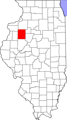 Location in the U.S. state of Illinois | |
 Illinois's location in the U.S. | |
| Founded | 1825 |
| Named for | Henry Knox |
| Seat | Galesburg |
| Largest city | Galesburg |
| Area | |
| • Total | 720 sq mi (1,865 km2) |
| • Land | 716 sq mi (1,854 km2) |
| • Water | 3.4 sq mi (9 km2), 0.5% |
| Population | |
| • (2010) | 52,919 |
| • Density | 74/sq mi (29/km2) |
| Congressional district | 17th |
| Time zone | Central: UTC−6/−5 |
| Website |
www |
Knox County is a county in the U.S. state of Illinois. According to the 2010 census, it had a population of 52,919.[1] Its county seat is Galesburg.[2]
Knox County comprises the Galesburg, IL Micropolitan Statistical Area.
History
Knox County was named in honor of Henry Knox, the first US Secretary of War.[3]
The first "Knox County" in what today is Illinois was unrelated to the modern incarnation. In 1790, the land of the Indiana Territory that was to become Illinois was divided into two counties: St. Clair and Knox. The latter included land in what was to become Indiana. When Knox County, Indiana, was formed from this portion of the county in 1809, the Illinois portions were subdivided into counties that were given other names.
The modern Knox County, Illinois, was organized in 1825, from Fulton County, itself a portion of the original St. Clair County.
Like its neighbor to the south, Fulton County, for its Spoon River Drive, Knox County is also known for a similar scenic drive fall festival the first two weekends in October, the Knox County Drive.
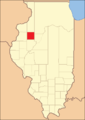 Knox County between its creation in 1825 and 1831
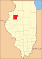 Knox County between 1831 and 1839
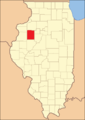 Knox County in 1839, when it was reduced slightly to its current size
Geography
According to the U.S. Census Bureau, the county has a total area of 720 square miles (1,900 km2), of which 716 square miles (1,850 km2) is land and 3.4 square miles (8.8 km2) (0.5%) is water.[4]
Climate and weather
| Galesburg, Illinois | ||||||||||||||||||||||||||||||||||||||||||||||||||||||||||||
|---|---|---|---|---|---|---|---|---|---|---|---|---|---|---|---|---|---|---|---|---|---|---|---|---|---|---|---|---|---|---|---|---|---|---|---|---|---|---|---|---|---|---|---|---|---|---|---|---|---|---|---|---|---|---|---|---|---|---|---|---|
| Climate chart (explanation) | ||||||||||||||||||||||||||||||||||||||||||||||||||||||||||||
| ||||||||||||||||||||||||||||||||||||||||||||||||||||||||||||
| ||||||||||||||||||||||||||||||||||||||||||||||||||||||||||||
In recent years, average temperatures in the county seat of Galesburg have ranged from a low of 13 °F (−11 °C) in January to a high of 85 °F (29 °C) in July, although a record low of −25 °F (−32 °C) was recorded in January 1982 and a record high of 102 °F (39 °C) was recorded in July 1983. Average monthly precipitation ranged from 1.41 inches (36 mm) in January to 4.37 inches (111 mm) in July.[5]
Major highways
Adjacent counties
- Henry County - north
- Stark County - east
- Peoria County - southeast
- Fulton County - south
- Warren County - west
- Mercer County - northwest
Demographics
| Historical population | |||
|---|---|---|---|
| Census | Pop. | %± | |
| 1830 | 274 | — | |
| 1840 | 7,060 | 2,476.6% | |
| 1850 | 13,279 | 88.1% | |
| 1860 | 28,663 | 115.9% | |
| 1870 | 39,522 | 37.9% | |
| 1880 | 38,344 | −3.0% | |
| 1890 | 38,752 | 1.1% | |
| 1900 | 43,612 | 12.5% | |
| 1910 | 46,159 | 5.8% | |
| 1920 | 46,727 | 1.2% | |
| 1930 | 51,336 | 9.9% | |
| 1940 | 52,250 | 1.8% | |
| 1950 | 54,366 | 4.0% | |
| 1960 | 61,280 | 12.7% | |
| 1970 | 61,280 | 0.0% | |
| 1980 | 61,607 | 0.5% | |
| 1990 | 56,393 | −8.5% | |
| 2000 | 55,836 | −1.0% | |
| 2010 | 52,919 | −5.2% | |
| Est. 2016 | 50,938 | [6] | −3.7% |
| U.S. Decennial Census[7] 1790-1960[8] 1900-1990[9] 1990-2000[10] 2010-2013[1] | |||
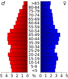
As of the 2010 United States Census, there were 52,919 people, 21,535 households, and 13,324 families residing in the county.[11] The population density was 73.9 inhabitants per square mile (28.5/km2). There were 24,077 housing units at an average density of 33.6 per square mile (13.0/km2).[4] The racial makeup of the county was 87.5% white, 7.2% black or African American, 0.6% Asian, 0.2% American Indian, 1.9% from other races, and 2.5% from two or more races. Those of Hispanic or Latino origin made up 4.8% of the population.[11] In terms of ancestry, 23.1% were German, 14.9% were Irish, 11.7% were English, 11.6% were Swedish, and 8.0% were American.[12]
Of the 21,535 households, 27.2% had children under the age of 18 living with them, 45.7% were married couples living together, 11.9% had a female householder with no husband present, 38.1% were non-families, and 32.3% of all households were made up of individuals. The average household size was 2.27 and the average family size was 2.84. The median age was 42.0 years.[11]
The median income for a household in the county was $39,545 and the median income for a family was $51,740. Males had a median income of $42,067 versus $25,380 for females. The per capita income for the county was $20,908. About 10.9% of families and 15.5% of the population were below the poverty line, including 24.7% of those under age 18 and 7.3% of those age 65 or over.[13]
Communities
Cities
Villages
Census-designated places
Other unincorporated communities
Townships
Knox County is divided into twenty-one townships:
Politics
| Year | Republican | Democratic | Third Parties |
|---|---|---|---|
| 2016 | 47.7% 10,737 | 44.8% 10,083 | 7.5% 1,683 |
| 2012 | 40.3% 9,408 | 57.6% 13,451 | 2.1% 497 |
| 2008 | 39.1% 9,419 | 58.9% 14,191 | 2.0% 488 |
| 2004 | 45.0% 11,111 | 54.3% 13,403 | 0.8% 194 |
| 2000 | 42.8% 9,912 | 54.3% 12,572 | 3.0% 690 |
| 1996 | 34.7% 7,822 | 55.4% 12,487 | 9.9% 2,239 |
| 1992 | 32.9% 8,331 | 49.5% 12,524 | 17.6% 4,441 |
| 1988 | 45.8% 10,842 | 53.8% 12,752 | 0.5% 106 |
| 1984 | 55.2% 14,974 | 44.3% 12,027 | 0.5% 121 |
| 1980 | 56.9% 14,907 | 33.4% 8,749 | 9.7% 2,542 |
| 1976 | 54.4% 14,123 | 44.4% 11,525 | 1.2% 319 |
| 1972 | 64.7% 17,315 | 34.9% 9,333 | 0.4% 118 |
| 1968 | 53.9% 14,216 | 36.8% 9,707 | 9.4% 2,473 |
| 1964 | 46.1% 12,850 | 53.9% 15,000 | |
| 1960 | 60.1% 17,938 | 39.8% 11,889 | 0.1% 23 |
| 1956 | 66.0% 18,656 | 33.8% 9,558 | 0.1% 37 |
| 1952 | 64.2% 18,569 | 35.8% 10,354 | 0.1% 17 |
| 1948 | 60.2% 15,016 | 39.2% 9,772 | 0.7% 164 |
| 1944 | 61.0% 15,964 | 38.5% 10,070 | 0.5% 126 |
| 1940 | 57.8% 17,459 | 41.7% 12,597 | 0.6% 168 |
| 1936 | 50.5% 14,712 | 47.0% 13,697 | 2.5% 715 |
| 1932 | 49.1% 12,244 | 49.3% 12,282 | 1.6% 392 |
| 1928 | 72.3% 16,151 | 26.8% 5,993 | 0.8% 186 |
| 1924 | 65.9% 12,968 | 13.3% 2,617 | 20.8% 4,095 |
| 1920 | 73.9% 12,559 | 16.8% 2,852 | 9.4% 1,594 |
| 1916 | 58.8% 10,918 | 36.6% 6,785 | 4.6% 860 |
| 1912 | 16.7% 1,750 | 26.4% 2,758 | 56.9% 5,959 |
| 1908 | 63.8% 7,084 | 29.5% 3,277 | 6.6% 737 |
| 1904 | 73.8% 7,566 | 18.0% 1,849 | 8.1% 832 |
| 1900 | 67.6% 7,810 | 28.6% 3,299 | 3.8% 440 |
| 1896 | 67.4% 7,681 | 30.5% 3,480 | 2.1% 236 |
| 1892 | 60.5% 5,800 | 32.1% 3,073 | 7.5% 715 |
Knox County’s political history is typical of Yankee-settled Northern Illinois. It leaned Whig during its early elections – although giving a plurality to Franklin Pierce in 1852 – and become powerfully Republican following that party’s formation. Although Knox did support Progressive Theodore Roosevelt against conservative incumbent President William Howard Taft in 1912, it was Franklin D. Roosevelt’s 1932 landslide before Knox County again gave the Democratic Party so much as a plurality, and it did not give a Democratic absolute majority until Lyndon B. Johnson gained such against the anti-Yankee, Southern-leaning Barry Goldwater in 1964.
Since then, Knox County gradually trended Democratic for the following four decades, so that Michael Dukakis in his losing 1988 campaign was to carry the county by the same margin as Johnson had done in 1964. During the 1990s and 2000s, Knox was a solidly Democratic county, voting Democratic by at least nine percentage points in every election from 1992 to 2012. The 2016 election, in the shadow of high unemployment in the “Rust Belt” saw a swing of over twenty percentage points to Donald Trump, who became the first Republican victor in the county since Ronald Reagan in 1984 when he came within 3,819 votes of cleansweeping all fifty states.
See also
References
- 1 2 "State & County QuickFacts". United States Census Bureau. Archived from the original on July 13, 2011. Retrieved July 6, 2014.
- ↑ "Find a County". National Association of Counties. Archived from the original on 2011-05-31. Retrieved 2011-06-07.
- ↑ Gannett, Henry (1905). The Origin of Certain Place Names in the United States. Government Printing Office. p. 177.
- 1 2 "Population, Housing Units, Area, and Density: 2010 - County". United States Census Bureau. Retrieved 2015-07-12.
- 1 2 "Monthly Averages for Galesburg, Illinois". The Weather Channel. Retrieved 2011-01-27.
- ↑ "Population and Housing Unit Estimates". Retrieved June 9, 2017.
- ↑ "U.S. Decennial Census". United States Census Bureau. Archived from the original on May 12, 2015. Retrieved July 6, 2014.
- ↑ "Historical Census Browser". University of Virginia Library. Retrieved July 6, 2014.
- ↑ "Population of Counties by Decennial Census: 1900 to 1990". United States Census Bureau. Retrieved July 6, 2014.
- ↑ "Census 2000 PHC-T-4. Ranking Tables for Counties: 1990 and 2000" (PDF). United States Census Bureau. Retrieved July 6, 2014.
- 1 2 3 "DP-1 Profile of General Population and Housing Characteristics: 2010 Demographic Profile Data". United States Census Bureau. Retrieved 2015-07-12.
- ↑ "DP02 SELECTED SOCIAL CHARACTERISTICS IN THE UNITED STATES – 2006-2010 American Community Survey 5-Year Estimates". United States Census Bureau. Retrieved 2015-07-12.
- ↑ "DP03 SELECTED ECONOMIC CHARACTERISTICS – 2006-2010 American Community Survey 5-Year Estimates". United States Census Bureau. Retrieved 2015-07-12.
- ↑ Leip, David. "Dave Leip's Atlas of U.S. Presidential Elections". uselectionatlas.org. Retrieved 19 March 2018.
Further reading
- Charles C. Chapman and Co., History of Knox County, Illinois: Together with Sketches of the Cities, Villages and Townships; Record of its Volunteers in the Late War; Educational, Religious, Civil and Political History; Portraits of Prominent Persons and Biographical Sketches of the Subscribers; History of Illinois, Abstracts of the State Laws, Etc., Etc., Etc. Chicago: Blakely, Brown and Marsh, Printers, 1878.
- Fred R. Jelliff, Annals of Knox County: Commemorating Centennial of Admission of Illinois as State of the Union in 1818. Galesburg, IL: Republican Register Printing, 1918.
- Portrait and Biographical Album of Knox County, Illinois, Containing Full Page Portraits and Biographical Sketches of Prominent and Representative Citizens of the County, Together with Portraits and Biographies of All the Governors of Illinois, and of the Presidents of the United States: Also Containing a History of the County from Its Earliest Settlement Up to the Present Time. Chicago: Biographical Publishing Company, 1886.
External links
Places adjacent to Knox County, Illinois | ||||||||||
|---|---|---|---|---|---|---|---|---|---|---|
| ||||||||||
Municipalities and communities of Knox County, Illinois, United States | ||
|---|---|---|
| Cities | ||
| Villages | ||
| Townships | ||
| CDPs | ||
| Other unincorporated communities | ||
| Ghost towns | ||
| Footnotes | ‡This populated place also has portions in an adjacent county or counties | |
