Carmi, Illinois
| Carmi | |
|---|---|
| City | |
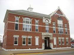 White County Courthouse in downtown Carmi | |
| Etymology: Biblical: Carmi, nephew of Joseph. | |
| Motto(s): Where northern vigor meets southern hospitality | |
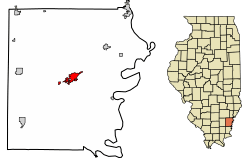 Location of Carmi in White County, Illinois. | |
.svg.png) Location of Illinois in the United States | |
| Coordinates: 38°5′18″N 88°10′5″W / 38.08833°N 88.16806°WCoordinates: 38°5′18″N 88°10′5″W / 38.08833°N 88.16806°W | |
| Country | United States |
| State | Illinois |
| County | White |
| Founded | 1816 |
| Government | |
| • Type | Mayor-council government |
| • Mayor | Jeff Pollard |
| Area[1] | |
| • Total | 2.54 sq mi (6.57 km2) |
| • Land | 2.50 sq mi (6.49 km2) |
| • Water | 0.03 sq mi (0.08 km2) |
| Elevation | 387 ft (118 m) |
| Population (2010) | |
| • Total | 5,240 |
| • Estimate (2017)[2] | 4,971 |
| • Density | 2,038.74/sq mi (787.17/km2) |
| Time zone | UTC-6 (CST) |
| • Summer (DST) | UTC-5 (CDT) |
| ZIP Code(s) | 62821 |
| Area code(s) | 618 |
| FIPS code | 17-11293 |
| Wikimedia Commons | Carmi, Illinois |
| Website |
www |
Carmi is a city which is the county seat of White County, Illinois, United States, along the Little Wabash River, where the population was 5,422 at the 2000 census.
History
Carmi post office has been in operation since 1817,[3] and then a WPA oil on canvas mural called Service to the Farmer by Davenport Griffen was first displayed there in 1939. Carmi is a biblical name.[4]
Geography
According to the 2010 census, Carmi has a total area of 2.531 square miles (6.56 km2), of which 2.5 square miles (6.47 km2) (or 98.78%) is land and 0.031 square miles (0.08 km2) (or 1.22%) is water.[5]
Demographics
| Historical population | |||
|---|---|---|---|
| Census | Pop. | %± | |
| 1880 | 2,512 | — | |
| 1890 | 2,785 | 10.9% | |
| 1900 | 2,939 | 5.5% | |
| 1910 | 2,833 | −3.6% | |
| 1920 | 2,667 | −5.9% | |
| 1930 | 2,932 | 9.9% | |
| 1940 | 4,098 | 39.8% | |
| 1950 | 5,574 | 36.0% | |
| 1960 | 6,152 | 10.4% | |
| 1970 | 6,033 | −1.9% | |
| 1980 | 6,107 | 1.2% | |
| 1990 | 5,564 | −8.9% | |
| 2000 | 5,422 | −2.6% | |
| 2010 | 5,240 | −3.4% | |
| Est. 2017 | 4,971 | [2] | −5.1% |
| U.S. Decennial Census[6] | |||
As of the census[7] of 2000, there were 5,422 people, 2,390 households, and 1,477 families residing in the city. The population density was 2,187.7 people per square mile (844.1/km²). There were 2,667 housing units at an average density of 1,076.1/sq mi (415.2/km²). The racial makeup of the city was 98.30% White, 0.48% African American, 0.35% Native American, 0.24% Asian, 0.06% from other races, and 0.57% from two or more races. Hispanic or Latino of any race were 0.65% of the population.
There were 2,390 households out of which 23.8% had children under the age of 18 living with them, 49.7% were married couples living together, 9.2% had a female householder with no husband present, and 38.2% were non-families. 35.3% of all households were made up of individuals and 20.3% had someone living alone who was 65 years of age or older. The average household size was 2.16 and the average family size was 2.78.
In the city, the population was spread out with 20.4% under the age of 18, 8.2% from 18 to 24, 23.7% from 25 to 44, 21.7% from 45 to 64, and 25.9% who were 65 years of age or older. The median age was 43 years. For every 100 females, there were 84.4 males. For every 100 females age 18 and over, there were 81.7 males.
The median income for a household in the city was $25,667, and the median income for a family was $32,456. Males had a median income of $30,735 versus $16,693 for females. The per capita income for the city was $15,886. About 11.7% of families and 15.1% of the population were below the poverty line, including 21.4% of those under age 18 and 11.6% of those age 65 or over.
Education
College
- Southeastern Illinois College David L. Stanley White County Center (web site)
Public
- Carmi-White County Community School District #5 (web site)
- Carmi-White County High School/JR. High - grades 7-12
- Carmi-White County Middle School - grades 4-6
- Jefferson Attendance Center - grades 2-3
- Lincoln Attendance Center - grades K-1
Private
- Carmi Christian School (web site)
Media
Radio
- Carmi Times (web site)
- Carmi Chronicle (web site)
Notable people
- Matt Lydick, Musician/songwriter
- Denton Aud, State Attorney
- Lew "The King" Brockett Professional baseball player
- Orlando Burrell, White County judge, White County Sheriff, congressman
- Roy Clippinger, congressman
- Everton Conger, Union Army Lieutenant colonel (Civil War), federal territorial judge, involved in manhunt for John Wilkes Booth
- Caswell J. Crebs, Illinois Supreme Court justice
- John M. Crebs, Union Army Lieutenant colonel (Civil War), congressman
- Josh Elder, comic book creator (Mail Order Ninja, StarCraft: Frontline)
- Ivan A. Elliott, Illinois Attorney General
- Frederick J. Karch, Brigadier General with the U.S. Marine Corps (World War II, Vietnam)
- Samuel D. Lockwood, Illinois Attorney General, Illinois Secretary of State, Illinois Supreme Court justice
- Glenn Poshard, state senator, congressman, Illinois Gubernatorial Candidate, and president of Southern Illinois University
- Shelby Pollard, musician, Minor Characters
- Sandy Rios, talk show host and Fox News Channel contributor
- John McCracken Robinson, senator, Illinois Supreme Court justice
- Run Kid Run, Christian band
- Side Walk Slam, punk rock band
- Jeff Stryker, adult film actor, AVN Award Hall of Fame inductee
- Bob Sykes, professional baseball player
- James R. Williams, congressman
- William Wilson, Chief Justice of the Illinois Supreme Court
See also
References
- ↑ "2016 U.S. Gazetteer Files". United States Census Bureau. Retrieved Jun 29, 2017.
- 1 2 "City and Town Population Totals: 2010-2017". Retrieved May 28, 2018.
- ↑ "White County". Jim Forte Postal History. Archived from the original on 5 February 2016. Retrieved 27 April 2015.
- ↑ Allen, John W. (January 11, 1963). "Place Names Have Colorful History". The Southeast Missourian. p. 6. Retrieved 27 April 2015.
- ↑ "G001 - Geographic Identifiers - 2010 Census Summary File 1". United States Census Bureau. Retrieved 2015-12-25.
- ↑ "Census of Population and Housing". Census.gov. Archived from the original on May 12, 2015. Retrieved June 4, 2015.
- ↑ "American FactFinder". United States Census Bureau. Archived from the original on 2013-09-11. Retrieved 2008-01-31.
Municipalities and communities of White County, Illinois, United States | ||
|---|---|---|
| Cities | ||
| Villages | ||
| Townships | ||
| Unincorporated communities |
| |
| Footnotes | ‡This populated place also has portions in an adjacent county or counties | |
| Counties |  | |
|---|---|---|
| Mid-sized cities (25,000+) | ||
| Small Cities (10,000-25,000) | ||
| Small Cities (5,000-10,000) | ||
| Interstates | ||
| Airports/Military bases |
| |
| Universities | ||
| Colleges | ||
| Sports teams based in the Southern Illinois | ||