Montgomery County, Illinois
| Montgomery County, Illinois | |
|---|---|
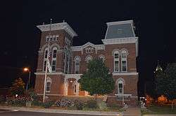 Montgomery County Courthouse, Hillsboro | |
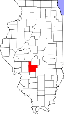 Location in the U.S. state of Illinois | |
 Illinois's location in the U.S. | |
| Founded | 1821 |
| Named for | Richard Montgomery |
| Seat | Hillsboro |
| Largest city | Litchfield |
| Area | |
| • Total | 710 sq mi (1,839 km2) |
| • Land | 704 sq mi (1,823 km2) |
| • Water | 6.0 sq mi (16 km2), 0.8% |
| Population | |
| • (2010) | 30,104 |
| • Density | 43/sq mi (17/km2) |
| Congressional district | 13th |
| Time zone | Central: UTC−6/−5 |
| Website |
www |
Montgomery County is a county located in the U.S. state of Illinois. According to the 2010 census, it had a population of 30,104.[1] Its county seat is Hillsboro.[2][3]
History
Montgomery County was formed in 1821 out of Bond and Madison counties. It was named in honor of Richard Montgomery, an American Revolutionary War general killed in 1775 while attempting to capture Quebec City, Canada.[4] Perrin's 1882 History of Montgomery County relates that the County was named in honor of Gen. Montgomery, but goes on to say that "others are dubious as to whence it received its name."
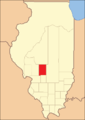 Montgomery County from the time of its creation to 1827
 Montgomery County between 1827 and 1839
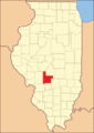 Montgomery in 1839, reduced to its present borders
Geography
According to the U.S. Census Bureau, the county has a total area of 710 square miles (1,800 km2), of which 704 square miles (1,820 km2) is land and 6.0 square miles (16 km2) (0.8%) is water.[5]
Climate and weather
| Hillsboro, Illinois | ||||||||||||||||||||||||||||||||||||||||||||||||||||||||||||
|---|---|---|---|---|---|---|---|---|---|---|---|---|---|---|---|---|---|---|---|---|---|---|---|---|---|---|---|---|---|---|---|---|---|---|---|---|---|---|---|---|---|---|---|---|---|---|---|---|---|---|---|---|---|---|---|---|---|---|---|---|
| Climate chart (explanation) | ||||||||||||||||||||||||||||||||||||||||||||||||||||||||||||
| ||||||||||||||||||||||||||||||||||||||||||||||||||||||||||||
| ||||||||||||||||||||||||||||||||||||||||||||||||||||||||||||
In recent years, average temperatures in the county seat of Hillsboro have ranged from a low of 21 °F (−6 °C) in January to a high of 91 °F (33 °C) in July, although a record low of −22 °F (−30 °C) was recorded in February 1905 and a record high of 114 °F (46 °C) was recorded in July 1954. Average monthly precipitation ranged from 2.00 inches (51 mm) in February to 4.31 inches (109 mm) in May.[6]
Adjacent counties
- Sangamon County - north
- Christian County - northeast
- Shelby County - east
- Fayette County - southeast
- Bond County - south
- Madison County - southwest
- Macoupin County - west
Transportation
Major highways
Airports
Litchfield Municipal Airport is located in Montgomery County, two nautical miles (3.7 km) southwest of the central business district of Litchfield, Illinois.
Demographics
| Historical population | |||
|---|---|---|---|
| Census | Pop. | %± | |
| 1830 | 2,953 | — | |
| 1840 | 4,490 | 52.0% | |
| 1850 | 6,277 | 39.8% | |
| 1860 | 13,979 | 122.7% | |
| 1870 | 25,314 | 81.1% | |
| 1880 | 28,078 | 10.9% | |
| 1890 | 30,003 | 6.9% | |
| 1900 | 30,836 | 2.8% | |
| 1910 | 35,311 | 14.5% | |
| 1920 | 41,403 | 17.3% | |
| 1930 | 35,278 | −14.8% | |
| 1940 | 34,499 | −2.2% | |
| 1950 | 32,460 | −5.9% | |
| 1960 | 31,244 | −3.7% | |
| 1970 | 30,260 | −3.1% | |
| 1980 | 31,686 | 4.7% | |
| 1990 | 30,728 | −3.0% | |
| 2000 | 30,652 | −0.2% | |
| 2010 | 30,104 | −1.8% | |
| Est. 2016 | 28,952 | [7] | −3.8% |
| U.S. Decennial Census[8] 1790-1960[9] 1900-1990[10] 1990-2000[11] 2010-2013[1] | |||
As of the 2010 United States Census, there were 30,104 people, 11,652 households, and 7,806 families residing in the county.[12] The population density was 42.8 inhabitants per square mile (16.5/km2). There were 13,080 housing units at an average density of 18.6 per square mile (7.2/km2).[5] The racial makeup of the county was 95.1% white, 3.2% black or African American, 0.4% Asian, 0.2% American Indian, 0.5% from other races, and 0.7% from two or more races. Those of Hispanic or Latino origin made up 1.5% of the population.[12] In terms of ancestry, 27.8% were German, 11.2% were Irish, 10.1% were English, and 9.8% were American.[13]
Of the 11,652 households, 29.8% had children under the age of 18 living with them, 51.7% were married couples living together, 10.2% had a female householder with no husband present, 33.0% were non-families, and 28.4% of all households were made up of individuals. The average household size was 2.38 and the average family size was 2.87. The median age was 41.9 years.[12]
The median income for a household in the county was $40,864 and the median income for a family was $56,945. Males had a median income of $40,749 versus $29,426 for females. The per capita income for the county was $21,700. About 10.9% of families and 14.0% of the population were below the poverty line, including 22.7% of those under age 18 and 7.4% of those age 65 or over.[14]
Communities
Cities
Villages
Unincorporated communities
- Chapman
- Honey Bend
- Kortcamp
- Van Burensburg
- Zanesville
- Zenobia
Townships
- Audubon Township
- Bois D'Arc Township
- Butler Grove Township
- East Fork Township
- Fillmore Township
- Grisham Township
- Harvel Township
- Hillsboro Township
- Irving Township
- Nokomis Township
- North Litchfield Township
- Pitman Township
- Raymond Township
- Rountree Township
- South Litchfield Township
- Walshville Township
- Witt Township
- Zanesville Township
Former Townships
Notable people
- Otto Funk (1868–1934) Violinist who achieved fame (and a Guinness Book of Records entry) by walking from New York to San Francisco in the depression-era, "playing the fiddle every step of the way." When he died in 1934 at the age of 65, he was accorded the biggest funeral in the history of Montgomery County.
Politics
| Year | Republican | Democratic | Third Parties |
|---|---|---|---|
| 2016 | 66.5% 8,630 | 27.0% 3,504 | 6.5% 844 |
| 2012 | 55.6% 6,776 | 41.5% 5,058 | 2.9% 354 |
| 2008 | 47.6% 6,150 | 50.3% 6,491 | 2.1% 268 |
| 2004 | 53.0% 6,851 | 46.2% 5,979 | 0.8% 100 |
| 2000 | 47.6% 6,226 | 50.0% 6,542 | 2.5% 325 |
| 1996 | 37.8% 4,770 | 50.2% 6,338 | 12.1% 1,523 |
| 1992 | 29.7% 4,407 | 50.0% 7,424 | 20.3% 3,006 |
| 1988 | 46.4% 6,388 | 53.0% 7,293 | 0.6% 78 |
| 1984 | 56.1% 8,191 | 43.6% 6,360 | 0.4% 54 |
| 1980 | 58.0% 8,947 | 37.1% 5,721 | 4.8% 747 |
| 1976 | 46.6% 7,379 | 52.5% 8,322 | 0.9% 147 |
| 1972 | 56.7% 9,025 | 43.1% 6,858 | 0.2% 30 |
| 1968 | 46.2% 7,547 | 44.8% 7,318 | 9.0% 1,474 |
| 1964 | 37.8% 6,425 | 62.2% 10,581 | 0.0% 0 |
| 1960 | 51.0% 9,178 | 49.0% 8,815 | 0.1% 14 |
| 1956 | 56.4% 9,945 | 43.6% 7,692 | 0.1% 8 |
| 1952 | 55.0% 10,014 | 45.0% 8,195 | 0.1% 16 |
| 1948 | 50.7% 8,348 | 48.0% 7,902 | 1.3% 205 |
| 1944 | 52.7% 8,989 | 46.1% 7,855 | 1.2% 201 |
| 1940 | 51.7% 10,497 | 47.5% 9,654 | 0.9% 174 |
| 1936 | 42.9% 8,140 | 53.4% 10,132 | 3.7% 692 |
| 1932 | 34.7% 5,945 | 61.1% 10,456 | 4.2% 725 |
| 1928 | 54.3% 8,999 | 44.6% 7,392 | 1.1% 184 |
| 1924 | 47.3% 8,022 | 33.1% 5,622 | 19.6% 3,331 |
| 1920 | 52.9% 7,429 | 33.9% 4,756 | 13.2% 1,854 |
| 1916 | 44.7% 7,065 | 49.9% 7,903 | 5.4% 856 |
| 1912 | 18.2% 1,476 | 45.7% 3,705 | 36.1% 2,928 |
| 1908 | 45.6% 3,782 | 47.2% 3,909 | 7.2% 596 |
| 1904 | 48.0% 3,489 | 43.7% 3,181 | 8.3% 602 |
| 1900 | 45.4% 3,583 | 51.7% 4,078 | 2.9% 225 |
| 1896 | 46.0% 3,622 | 52.3% 4,117 | 1.7% 132 |
| 1892 | 41.0% 2,935 | 51.8% 3,707 | 7.2% 515 |
See also
References
- Specific
- 1 2 "State & County QuickFacts". United States Census Bureau. Archived from the original on July 15, 2011. Retrieved July 7, 2014.
- ↑ "Hillsboro Illinois". City of Hillsboro. Retrieved 15 February 2012.
- ↑ "Find a County". National Association of Counties. Retrieved 2011-06-07.
- ↑ Allan H. Keith, Historical Stories: About Greenville and Bond County, IL. Consulted on August 15, 2007.
- 1 2 "Population, Housing Units, Area, and Density: 2010 - County". United States Census Bureau. Retrieved 2015-07-12.
- 1 2 "Monthly Averages for Hillsboro, Illinois". The Weather Channel. Retrieved 2011-01-27.
- ↑ "Population and Housing Unit Estimates". Retrieved June 9, 2017.
- ↑ "U.S. Decennial Census". United States Census Bureau. Retrieved July 7, 2014.
- ↑ "Historical Census Browser". University of Virginia Library. Retrieved July 7, 2014.
- ↑ "Population of Counties by Decennial Census: 1900 to 1990". United States Census Bureau. Retrieved July 7, 2014.
- ↑ "Census 2000 PHC-T-4. Ranking Tables for Counties: 1990 and 2000" (PDF). United States Census Bureau. Retrieved July 7, 2014.
- 1 2 3 "DP-1 Profile of General Population and Housing Characteristics: 2010 Demographic Profile Data". United States Census Bureau. Retrieved 2015-07-12.
- ↑ "DP02 SELECTED SOCIAL CHARACTERISTICS IN THE UNITED STATES – 2006-2010 American Community Survey 5-Year Estimates". United States Census Bureau. Retrieved 2015-07-12.
- ↑ "DP03 SELECTED ECONOMIC CHARACTERISTICS – 2006-2010 American Community Survey 5-Year Estimates". United States Census Bureau. Retrieved 2015-07-12.
- ↑ http://uselectionatlas.org/RESULTS
- General
- History of Montgomery County, Illinois, Perrin, 1882
External links
Places adjacent to Montgomery County, Illinois | ||||||||||
|---|---|---|---|---|---|---|---|---|---|---|
| ||||||||||
Municipalities and communities of Montgomery County, Illinois, United States | ||
|---|---|---|
| Cities | ||
| Villages | ||
| Townships | ||
| Unincorporated communities | ||
| Footnotes | ‡This populated place also has portions in an adjacent county or counties | |
