Pike County, Illinois
| Pike County, Illinois | |
|---|---|
| County | |
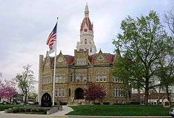 Pike County Courthouse, Pittsfield | |
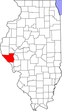 Location in the U.S. state of Illinois | |
 Illinois's location in the U.S. | |
| Founded | 31 January 1821 |
| Named for | Zebulon Pike |
| Seat | Pittsfield |
| Largest city | Pittsfield |
| Area | |
| • Total | 849 sq mi (2,199 km2) |
| • Land | 831 sq mi (2,152 km2) |
| • Water | 18 sq mi (47 km2), 2.1% |
| Population | |
| • (2010) | 16,430 |
| • Density | 20/sq mi (8/km2) |
| Congressional district | 18th |
| Time zone | Central: UTC−6/−5 |
| Website |
www |
Pike County is a county in the U.S. state of Illinois. According to the 2010 United States Census, it had a population of 16,430.[1] Its county seat is Pittsfield.[2]
History
Pike County was formed in January 1821 out of Madison County. It was named in honor of Zebulon Pike, leader of the Pike expedition in 1806 to map out the south and west portions of the Louisiana Purchase. Pike served at the Battle of Tippecanoe, and was killed in 1813 in the War of 1812.
Prior to the coming of the first European settler to the future Pike County, French traders, hunters, and travelers passed through the native forests and prairies. Originally Pike County began on the south junction of the Illinois and Mississippi rivers. The east boundary was the Illinois River north to the Kankakee River to the Indiana State line on north to Wisconsin territorial line and then west to the Mississippi River to the original point at the south end. The first county seat was Cole's Grove, a post town, in what later became Calhoun County. The Gazetteer of Illinois and Missouri, published in 1822, mentioned Chicago as "a village of Pike County" containing 12 or 15 houses and about 60 or 70 inhabitants.
The New Philadelphia Town Site was listed on the National Register of Historic Places in 2005 and designated a National Historic Landmark in 2009. Founded by Frank McWorter, an early free black settler in Pike County, it was the first town founded by a black man in the United States. McWorter had invested in land there sight unseen after purchasing the first few members of his family out of slavery. In 1836 he founded the town of New Philadelphia, near Barry. He was elected mayor and lived there the rest of his life. With the sale of land, he made enough money to purchase the freedom of his children. After the railroad bypassed the town, its growth slowed and it was eventually abandoned in the 20th century. The town site is now an archaeological site.
In the early 21st century, Pike County acquired notability as a whitetail deer hunting center, especially for bowhunting.
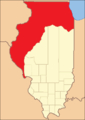 Pike County from the time of its creation to 1823
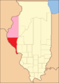 Pike County between 1823 and 1825, including unorganized territory temporarily attached to it[3]
 Pike County in 1825, reduced to its present borders
Geography
According to the US Census Bureau, the county has a total area of 849 square miles (2,200 km2), of which 831 square miles (2,150 km2) is land and 18 square miles (47 km2) (2.1%) is water.[4]
Pike County is located on the highlands between the Illinois River, which forms its eastern border, and the Mississippi River, which is the county's western border. It has two interstate highways, I-72, with bridges spanning both rivers to enter the county, and I-172 which extends about 300 feet (91 m) into the county to its intersection with I-72.
Climate and weather
| Pittsfield, Illinois | ||||||||||||||||||||||||||||||||||||||||||||||||||||||||||||
|---|---|---|---|---|---|---|---|---|---|---|---|---|---|---|---|---|---|---|---|---|---|---|---|---|---|---|---|---|---|---|---|---|---|---|---|---|---|---|---|---|---|---|---|---|---|---|---|---|---|---|---|---|---|---|---|---|---|---|---|---|
| Climate chart (explanation) | ||||||||||||||||||||||||||||||||||||||||||||||||||||||||||||
| ||||||||||||||||||||||||||||||||||||||||||||||||||||||||||||
| ||||||||||||||||||||||||||||||||||||||||||||||||||||||||||||
In recent years, average temperatures in the county seat of Pittsfield have ranged from a low of 15 °F (−9 °C) in January to a high of 86 °F (30 °C) in July, although a record low of −25 °F (−32 °C) was recorded in February 1905 and a record high of 115 °F (46 °C) was recorded in July 1954. Average monthly precipitation ranged from 1.74 inches (44 mm) in January to 4.11 inches (104 mm) in May.[5]
Major highways
Adjacent counties
- Adams County - north
- Brown County - northeast
- Scott County - east
- Morgan County - east
- Greene County - southeast
- Calhoun County - south
- Pike County, Missouri - southwest
- Ralls County, Missouri - west
- Marion County, Missouri - northwest
Pike County is one of the few US counties to border as many as nine counties. Illinois has two – Pike and LaSalle.
National protected area
Demographics
| Historical population | |||
|---|---|---|---|
| Census | Pop. | %± | |
| 1830 | 2,396 | — | |
| 1840 | 11,728 | 389.5% | |
| 1850 | 18,819 | 60.5% | |
| 1860 | 27,249 | 44.8% | |
| 1870 | 30,768 | 12.9% | |
| 1880 | 33,751 | 9.7% | |
| 1890 | 31,000 | −8.2% | |
| 1900 | 31,595 | 1.9% | |
| 1910 | 28,622 | −9.4% | |
| 1920 | 26,866 | −6.1% | |
| 1930 | 24,357 | −9.3% | |
| 1940 | 25,340 | 4.0% | |
| 1950 | 22,155 | −12.6% | |
| 1960 | 20,552 | −7.2% | |
| 1970 | 19,185 | −6.7% | |
| 1980 | 18,896 | −1.5% | |
| 1990 | 17,577 | −7.0% | |
| 2000 | 17,384 | −1.1% | |
| 2010 | 16,430 | −5.5% | |
| Est. 2016 | 15,950 | [6] | −2.9% |
| US Decennial Census[7] 1790-1960[8] 1900-1990[9] 1990-2000[10] 2010-2013[1] | |||
As of the 2010 United States Census, there were 16,430 people, 6,639 households, and 4,527 families residing in the county.[11] The population density was 19.8 inhabitants per square mile (7.6/km2). There were 7,951 housing units at an average density of 9.6 per square mile (3.7/km2).[4] The racial makeup of the county was 96.9% white, 1.7% black or African American, 0.2% Asian, 0.2% American Indian, 0.2% from other races, and 0.7% from two or more races. Those of Hispanic or Latino origin made up 1.0% of the population.[11] In terms of ancestry, 26.3% were German, 16.8% were American, 15.1% were English, and 13.4% were Irish.[12]
Of the 6,639 households, 30.3% had children under the age of 18 living with them, 54.5% were married couples living together, 9.0% had a female householder with no husband present, 31.8% were non-families, and 27.8% of all households were made up of individuals. The average household size was 2.38 and the average family size was 2.87. The median age was 42.5 years.[11]
The median income for a household in the county was $40,205 and the median income for a family was $50,426. Males had a median income of $39,071 versus $26,835 for females. The per capita income for the county was $19,996. About 11.3% of families and 15.4% of the population were below the poverty line, including 23.7% of those under age 18 and 11.2% of those age 65 or over.[13]
Politics
Pike County was reliably Democratic from the beginning through 1948; only 2 Republican Party nominees carried the county vote during that period. Since then it has usually voted for the Republican nominee (12 of 17 elections). The county is located in Illinois's 18th Congressional District and is currently represented by Republican Davin LaHood. For the Illinois House of Representatives, the county is located in the 100th district and is currently represented by Republican C.D. Davidsmeyer. The county is located in the 50th district of the Illinois Senate, and is currently represented by Republican William McCann.
| Year | Republican | Democratic | Third Parties |
|---|---|---|---|
| 2016 | 76.4% 5,754 | 18.8% 1,413 | 4.8% 363 |
| 2012 | 66.6% 4,860 | 31.2% 2,278 | 2.3% 164 |
| 2008 | 58.3% 4,457 | 39.6% 3,024 | 2.1% 162 |
| 2004 | 63.1% 5,032 | 35.7% 2,849 | 1.2% 99 |
| 2000 | 58.0% 4,706 | 39.4% 3,198 | 2.6% 208 |
| 1996 | 40.6% 3,225 | 45.3% 3,604 | 14.1% 1,123 |
| 1992 | 37.0% 3,342 | 44.4% 4,016 | 18.6% 1,679 |
| 1988 | 46.1% 3,965 | 53.7% 4,614 | 0.2% 20 |
| 1984 | 57.0% 5,295 | 42.7% 3,965 | 0.3% 25 |
| 1980 | 56.6% 5,301 | 39.5% 3,695 | 3.9% 365 |
| 1976 | 49.2% 4,975 | 49.5% 5,006 | 1.3% 129 |
| 1972 | 60.2% 5,940 | 39.4% 3,883 | 0.4% 40 |
| 1968 | 50.7% 5,035 | 42.2% 4,191 | 7.2% 713 |
| 1964 | 38.5% 4,113 | 61.5% 6,576 | 0.0% 0 |
| 1960 | 52.2% 5,965 | 47.8% 5,461 | 0.1% 10 |
| 1956 | 52.3% 5,920 | 47.6% 5,382 | 0.1% 16 |
| 1952 | 55.0% 6,382 | 45.0% 5,219 | 0.1% 10 |
| 1948 | 45.0% 4,722 | 54.1% 5,674 | 0.9% 98 |
| 1944 | 48.9% 5,633 | 50.6% 5,833 | 0.6% 66 |
| 1940 | 45.8% 6,619 | 53.2% 7,676 | 1.0% 146 |
| 1936 | 40.0% 5,589 | 58.6% 8,187 | 1.4% 198 |
| 1932 | 33.6% 4,181 | 64.4% 8,013 | 2.1% 258 |
| 1928 | 61.9% 6,705 | 37.0% 4,008 | 1.1% 123 |
| 1924 | 45.6% 4,989 | 49.6% 5,424 | 4.9% 530 |
| 1920 | 54.1% 5,564 | 41.6% 4,279 | 4.3% 437 |
| 1916 | 41.4% 5,293 | 54.7% 7,005 | 3.9% 501 |
| 1912 | 17.7% 1,169 | 50.9% 3,371 | 31.5% 2,083 |
| 1908 | 40.4% 2,932 | 53.1% 3,859 | 6.5% 474 |
| 1904 | 44.4% 3,007 | 46.0% 3,112 | 9.6% 650 |
| 1900 | 38.0% 3,045 | 58.9% 4,715 | 3.2% 252 |
| 1896 | 36.3% 3,111 | 62.1% 5,329 | 1.6% 139 |
| 1892 | 36.6% 2,751 | 46.5% 3,494 | 16.9% 1,268 |
Communities
Cities
Villages
Town
Unincorporated communities
Ghost towns
Townships
- Atlas Township
- Barry Township
- Chambersburg Township
- Cincinnati Township
- Derry Township
- Detroit Township
- Fairmount Township
- Flint Township
- Griggsville Township
- Hadley Township
- Hardin Township
- Kinderhook Township
- Levee Township
- Martinsburg Township
- Montezuma Township
- Newburg Township
- New Salem Township
- Pearl Township
- Perry Township
- Pittsfield Township
- Pleasant Hill Township
- Pleasant Vale Township
- Ross Township
- Spring Creek Township
See also
References
- 1 2 "State & County QuickFacts". US Census Bureau. Archived from the original on 16 July 2011. Retrieved 8 July 2014.
- ↑ "Find a County". National Association of Counties. Archived from the original on 31 May 2011. Retrieved 2011-06-07.
- ↑ White, Jesse. Origin and Evolution of Illinois Counties. State of Illinois, March 2010. "Archived copy" (PDF). Archived (PDF) from the original on 30 September 2012. Retrieved 26 September 2012.
- 1 2 "Population, Housing Units, Area, and Density: 2010 - County". US Census Bureau. Retrieved 12 July 2015.
- 1 2 "Monthly Averages for Pittsfield IL". The Weather Channel. Archived from the original on 23 October 2012. Retrieved 27 January 2011.
- ↑ "Population and Housing Unit Estimates". Archived from the original on 29 May 2017. Retrieved 9 June 2017.
- ↑ "US Decennial Census". US Census Bureau. Archived from the original on 12 May 2015. Retrieved 8 July 2014.
- ↑ "Historical Census Browser". University of Virginia Library. Archived from the original on 16 August 2012. Retrieved 8 July 2014.
- ↑ "Population of Counties by Decennial Census: 1900 to 1990". US Census Bureau. Archived from the original on 24 April 2014. Retrieved 8 July 2014.
- ↑ "Census 2000 PHC-T-4. Ranking Tables for Counties: 1990 and 2000" (PDF). US Census Bureau. Archived (PDF) from the original on 18 December 2014. Retrieved 8 July 2014.
- 1 2 3 "Profile of General Population and Housing Characteristics: 2010 Demographic Profile Data". US Census Bureau. Retrieved 12 July 2015.
- ↑ "Selected Social Characteristics in the United States – 2006-2010 American Community Survey 5-Year Estimates". US Census Bureau. Retrieved 12 July 2015.
- ↑ "Selected Economic Characteristics – 2006-2010 American Community Survey 5-Year Estimates". US Census Bureau. Retrieved 12 July 2015.
- ↑ Leip, David. "Dave Leip's Atlas of U.S. Presidential Elections". uselectionatlas.org. Archived from the original on 23 March 2018.
- ↑ http://faculty.las.illinois.edu/cfennell/NP/
External links
- Pike County Chamber of Commerce
- Pike County books and primary sources
- New Philadelphia Association
- Free Frank New Philadelphia Historic Preservation Foundation
- Christopher C. Fennell, "Updates on New Philadelphia Archaeology Project", University of Illinois, Urbana-Champaign
- New Philadelphia: A Multiracial Town on the Illinois Frontier, a National Park Service Teaching with Historic Places (TwHP) lesson plan
- Pike County Township Histories summation
- Pike County Illinois History
Places adjacent to Pike County, Illinois | |
|---|---|
Municipalities and communities of Pike County, Illinois, United States | ||
|---|---|---|
| Cities | ||
| Town | ||
| Villages | ||
| Townships | ||
| Unincorporated communities | ||
| Ghost towns | ||
