Ouistreham
| Ouistreham | ||
|---|---|---|
| Commune | ||
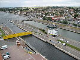 Ouistreham locks | ||
| ||
 Ouistreham Location within Normandy region  Ouistreham | ||
| Coordinates: 49°17′N 0°16′W / 49.28°N 0.26°WCoordinates: 49°17′N 0°16′W / 49.28°N 0.26°W | ||
| Country | France | |
| Region | Normandy | |
| Department | Calvados | |
| Arrondissement | Caen | |
| Canton | Ouistreham | |
| Intercommunality | CU Caen la Mer | |
| Government | ||
| • Mayor (2014-) | Romain Bail | |
| Area1 | 9.95 km2 (3.84 sq mi) | |
| Population (2008)2 | 9,322 | |
| • Density | 940/km2 (2,400/sq mi) | |
| Time zone | UTC+1 (CET) | |
| • Summer (DST) | UTC+2 (CEST) | |
| INSEE/Postal code | 14488 /14150 | |
| Website | http://ouistreham-rivabella.fr/ | |
|
1 French Land Register data, which excludes lakes, ponds, glaciers > 1 km2 (0.386 sq mi or 247 acres) and river estuaries. 2 Population without double counting: residents of multiple communes (e.g., students and military personnel) only counted once. | ||
Ouistreham (French pronunciation: [wistʁe.am]) is a commune in the Calvados department in Normandie region in northwestern France.
Ouistreham is a small port with fishing boats, leisure craft and a ferry-harbour. It serves as the port of the city of Caen. The town is about the mouth of the Canal de Caen à la Mer.
History
The name Ouistreham derives from ouistre - 'oyster' and Saxon ham= 'village'. It has been a trading port since the Middle Ages. The harbour is now a part of "Port de Caen-Ouistreham". Since the beginning of the 20th century, it has been a bathing beach on the "Riva Bella".
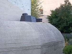
On 6 June 1944, No. 4 Commando landed at Ouistreham (codenamed Sword) and fought their way to Pegasus Bridge, with the 177 Free French of the No. 10 (Inter-Allied) Commando given the honour of spearheading the advance.[1] The assault on Ouistreham was featured in the movie The Longest Day, although the film location for Ouistreham was at the nearby village of Port-en-Bessin.
Population
| Historical population | ||
|---|---|---|
| Year | Pop. | ±% |
| 1793 | 854 | — |
| 1800 | 796 | −6.8% |
| 1806 | 1,050 | +31.9% |
| 1821 | 1,104 | +5.1% |
| 1831 | 1,162 | +5.3% |
| 1836 | 1,149 | −1.1% |
| 1841 | 1,359 | +18.3% |
| 1846 | 1,194 | −12.1% |
| 1851 | 1,133 | −5.1% |
| 1856 | 1,221 | +7.8% |
| 1861 | 1,259 | +3.1% |
| 1866 | 1,243 | −1.3% |
| 1872 | 1,249 | +0.5% |
| 1876 | 1,196 | −4.2% |
| 1881 | 1,222 | +2.2% |
| 1886 | 1,206 | −1.3% |
| 1891 | 1,194 | −1.0% |
| 1896 | 1,354 | +13.4% |
| 1901 | 1,688 | +24.7% |
| 1906 | 1,523 | −9.8% |
| 1911 | 1,574 | +3.3% |
| 1921 | 2,013 | +27.9% |
| 1926 | 2,220 | +10.3% |
| 1931 | 2,584 | +16.4% |
| 1936 | 2,790 | +8.0% |
| 1946 | 3,527 | +26.4% |
| 1954 | 4,342 | +23.1% |
| 1962 | 4,780 | +10.1% |
| 1968 | 5,223 | +9.3% |
| 1975 | 6,140 | +17.6% |
| 1982 | 6,310 | +2.8% |
| 1990 | 6,709 | +6.3% |
| 1999 | 8,674 | +29.3% |
| 2008 | 9,322 | +7.5% |
Transportation
The port of Ouistreham has a scheduled cross-Channel ferry service to Portsmouth, operated by Brittany Ferries. During 2017, Ouistreham became a new focal point for migrants and refugees trying to cross the Channel, leading the British government to contribute to improved security there.[2][3][4].
International relations
Twin towns – Sister cities
Ouistreham is twinned with:[5]

.svg.png)

See also
References
- ↑ Dunning, James (2003). The Fighting Fourth - No. 4 Commando at War 1940-45. Stroud: Sutton Publishing. p. 133. ISBN 0-7509-3095-0.
- ↑ "France town becomes transit point for refugees trying to reach UK". www.aljazeera.com. Retrieved 2018-03-22.
- ↑ Paris, Adam Sage (2017-10-07). "Migrant influx risks turning French port of Ouistreham into second Calais". The Times. ISSN 0140-0460. Retrieved 2018-03-22.
- ↑ "Ouistreham, nouvelle étape dans le rêve anglais des migrants". Le Monde.fr (in French). Retrieved 2018-03-22.
- 1 2 3 4 5 "National Commission for Decentralised cooperation". Délégation pour l’Action Extérieure des Collectivités Territoriales (Ministère des Affaires étrangères) (in French). Archived from the original on 2013-11-27. Retrieved 2013-12-26.
- ↑ "British towns twinned with French towns". Archant Community Media Ltd. Retrieved 2013-07-11.
| Wikimedia Commons has media related to Ouistreham. |
| Wikivoyage has a travel guide for Ouistreham. |