Clarbec
| Clarbec | ||
|---|---|---|
| Commune | ||
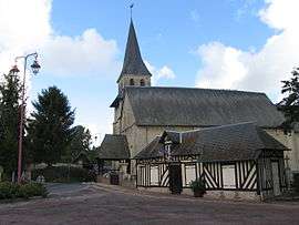 The church in Clarbec | ||
| ||
 Clarbec Location within Normandy region  Clarbec | ||
| Coordinates: 49°15′02″N 0°08′04″E / 49.2506°N 0.1344°ECoordinates: 49°15′02″N 0°08′04″E / 49.2506°N 0.1344°E | ||
| Country | France | |
| Region | Normandy | |
| Department | Calvados | |
| Arrondissement | Lisieux | |
| Canton | Pont-l'Évêque | |
| Intercommunality | Blangy Pont-l'Évêque | |
| Government | ||
| • Mayor (2008–2014) | Jean-Louis Marie | |
| Area1 | 9.7 km2 (3.7 sq mi) | |
| Population (2008)2 | 361 | |
| • Density | 37/km2 (96/sq mi) | |
| Time zone | UTC+1 (CET) | |
| • Summer (DST) | UTC+2 (CEST) | |
| INSEE/Postal code | 14161 /14130 | |
| Elevation |
47–140 m (154–459 ft) (avg. 90 m or 300 ft) | |
|
1 French Land Register data, which excludes lakes, ponds, glaciers > 1 km2 (0.386 sq mi or 247 acres) and river estuaries. 2 Population without double counting: residents of multiple communes (e.g., students and military personnel) only counted once. | ||
Clarbec is a commune in the Calvados department in the Normandy region in northwestern France.
Population
| Historical population | ||
|---|---|---|
| Year | Pop. | ±% |
| 1962 | 274 | — |
| 1968 | 309 | +12.8% |
| 1975 | 265 | −14.2% |
| 1982 | 251 | −5.3% |
| 1990 | 264 | +5.2% |
| 1999 | 275 | +4.2% |
| 2008 | 361 | +31.3% |
International relations
Clarbec is twinned with:
- Veitshöchheim, Germany since 1995
See also
References
| Wikimedia Commons has media related to Clarbec. |
This article is issued from
Wikipedia.
The text is licensed under Creative Commons - Attribution - Sharealike.
Additional terms may apply for the media files.