Émiéville
| Émiéville | |
|---|---|
| Commune | |
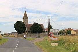 The church in Émiéville | |
 Émiéville Location within Normandy region  Émiéville | |
| Coordinates: 49°09′07″N 0°13′22″W / 49.1519°N 0.2228°WCoordinates: 49°09′07″N 0°13′22″W / 49.1519°N 0.2228°W | |
| Country | France |
| Region | Normandy |
| Department | Calvados |
| Arrondissement | Caen |
| Canton | Troarn |
| Intercommunality | Entre bois et marais |
| Government | |
| • Mayor (2008–2014) | Patrice Bernard |
| Area1 | 3.92 km2 (1.51 sq mi) |
| Population (2008)2 | 473 |
| • Density | 120/km2 (310/sq mi) |
| Time zone | UTC+1 (CET) |
| • Summer (DST) | UTC+2 (CEST) |
| INSEE/Postal code | 14237 /14630 |
| Elevation |
4–22 m (13–72 ft) (avg. 11 m or 36 ft) |
|
1 French Land Register data, which excludes lakes, ponds, glaciers > 1 km2 (0.386 sq mi or 247 acres) and river estuaries. 2 Population without double counting: residents of multiple communes (e.g., students and military personnel) only counted once. | |
Émiéville is a commune in the Calvados department in the Normandy region in northwestern France.
Population
| Historical population | ||
|---|---|---|
| Year | Pop. | ±% |
| 1962 | 237 | — |
| 1968 | 198 | −16.5% |
| 1975 | 255 | +28.8% |
| 1982 | 280 | +9.8% |
| 1990 | 356 | +27.1% |
| 1999 | 349 | −2.0% |
| 2008 | 473 | +35.5% |
See also
References
| Wikimedia Commons has media related to Émiéville. |
This article is issued from
Wikipedia.
The text is licensed under Creative Commons - Attribution - Sharealike.
Additional terms may apply for the media files.