Fumichon
| Fumichon | |
|---|---|
| Commune | |
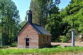 The chapel in Fumichon | |
 Fumichon Location within Normandy region  Fumichon | |
| Coordinates: 49°10′26″N 0°22′19″E / 49.1739°N 0.3719°ECoordinates: 49°10′26″N 0°22′19″E / 49.1739°N 0.3719°E | |
| Country | France |
| Region | Normandy |
| Department | Calvados |
| Arrondissement | Lisieux |
| Canton | Pont-l'Évêque |
| Intercommunality | CA Lisieux Normandie |
| Government | |
| • Mayor (2008–2014) | Gilbert Daufresne |
| Area1 | 6.63 km2 (2.56 sq mi) |
| Population (2008)2 | 276 |
| • Density | 42/km2 (110/sq mi) |
| Time zone | UTC+1 (CET) |
| • Summer (DST) | UTC+2 (CEST) |
| INSEE/Postal code | 14293 /14590 |
| Elevation |
103–171 m (338–561 ft) (avg. 160 m or 520 ft) |
|
1 French Land Register data, which excludes lakes, ponds, glaciers > 1 km2 (0.386 sq mi or 247 acres) and river estuaries. 2 Population without double counting: residents of multiple communes (e.g., students and military personnel) only counted once. | |
Fumichon is a commune in the Calvados department in the Normandy region in northwestern France.
Population
| Historical population | ||
|---|---|---|
| Year | Pop. | ±% |
| 1962 | 167 | — |
| 1968 | 146 | −12.6% |
| 1975 | 131 | −10.3% |
| 1982 | 178 | +35.9% |
| 1990 | 185 | +3.9% |
| 1999 | 244 | +31.9% |
| 2008 | 276 | +13.1% |
See also
References
| Wikimedia Commons has media related to Fumichon. |
This article is issued from
Wikipedia.
The text is licensed under Creative Commons - Attribution - Sharealike.
Additional terms may apply for the media files.